Quarries ancient mines footprints of the gods. Secrets of ancient civilizations. earth is an ancient mining mine for the great gods? Silver mines of Potosi, Bolivia
Knowledge multiplies sorrow
Ecclesiastes
Dear readers, after reading this article, you will most likely have to conduct a complete revision of your knowledge gained at school and higher educational institutions, at least in such disciplines as - history, geography, geology.
So let's go. I show you the logical chain of my reasoning and conclusions.
Today we have a huge number of artifacts that cannot be repeated today due to the lack of technology, equipment and specialists, and which testify that a global civilization existed on Earth for 200 years and earlier, compared to which we are children in the sandbox. A few examples:
Babolovskaya bath. Granite. Weight 48 tons.
Here is what a turner who visited her writes:

Alexandrian column weighing 600 tons, 27 meters high. Granite. The shape is not a cone, but an entasis. Without rotation in lathe it is impossible to make such a product. Try to order a smaller copy of such a product with an IDEAL radius from any hard foam or wood turner at least 2 meters high and 30 cm in diameter, but requiring only hand tools (planers, chisels, sandpaper) and he will refuse. 
Peru, Ollantaytambo. Polygonal docking of blocks weighing 40-120 tons. You can see the fit level. The blocks are aligned in three planes. 
Cappella Sansevero: Il Disinganno. Made from one piece of marble. It is impossible to make something like this without an advanced CNC machine. Over the past 50 years, nothing even remotely similar in complexity of execution has been made by any sculptor. Even with CNC machines.
marble tombstone at the Monumental Cemetery-Museum of Staglieno in Genoa. 
Stone bridge in Sevastopol. Each polygonal stone of the bridge is essentially a separate sculpture. An example of modern stone work behind the bridge on the left. Wall made of wild stone. By today's standards it is considered quite acceptable. 
Further, all the cities on the planet were built of stone in the antique style with pre-designed layouts of streets, avenues, embankments, etc. All cities had a stone bastion wall, the construction volume of which is often equal to the construction volume of the city itself. More on this in my article:
Geography of the global world before nuclear war on the example of ancient architecture and bastion stars
Also, here are some screenshots Google Earth photo of nuclear craters on the territory, for example, Belarus. It is easy to find hundreds of such funnels in almost all countries. The white traces around the sinkholes are broken limestone, the main building material of that time. 


In the funnels of Belarus given as an example, there is water, since the level of groundwater is apparently high. But there are a lot of funnels without water on the surface of the planet. For example, in Ukraine: 


As a result of the nuclear winter, almost all plants froze to death and polar caps formed. This confirms the almost complete absence of trees older than 200 years in the northern hemisphere. Some of them burned out in the war, some froze. To visually evaluate this, type Roger Fenton Crimea or James Robertson Crimea in Google and click show pictures. You will see photographs of these two first war photographers sent to the Crimea in 1853 (already after the nuclear war, approximately 40 years later) to photograph the siege of Sevastopol. Compare vegetation then and now.
An example of one photo of Fenton near Sevastopol: 
Type in Google "Siberia photo of the 19th century." You will see many photographs from the end of the 19th century, in which trees have just begun to grow. For example, Sverdlovsk region: 
After this war, we rolled back in development, to the level of a feudal society. The Anglo-Saxons had a profit, since they got the least, they crushed the remnants of the world for 150 years for themselves, reinvented the coal-fired steam engine and off we go - now is the era of oil and gas, nuclear energy and our industrial complex uses the entire periodic table, which he allegedly invented in a dream. In fact, she was simply thrown through it.
Let's move on to the most interesting. I affirm that the current civilization is only a shadow of the bygone one. We are children compared to them. It is impossible to prove this through the industrial equipment of a past civilization, because it was simply disposed of, melted down. For example, after the collapse of the USSR, drunks dug trenches and cables and water pipes were taken out of the ground to be handed over to the metal collection point. But how to prove it? And it's easy. If the bygone civilization was much more developed than ours, then the entire periodic table was also needed for the functioning of its industrial-industrial and metallurgical complex. And all isotopes of elements. And there are almost all the elements of the periodic system in the rock and earth. So, I need to show you large-scale traces of the removal of rock from the slopes of the mountains, from the surface of the earth and from underground. As well as traces of processed waste rock after its enrichment at mining and processing plants of the past. This is what we'll do. I will use the analogy method, because it is very clear.
Until the 18th century, residential buildings were built almost exclusively from limestone.
For sawing, advanced machines were used, on which ideal parallelepipeds were made. In the seam of the masonry of such limestone blocks, you will not stick the blade. Here is a photo of a house in the Crimea, the first floor of which is covered with clay for three to four meters, as in all cities in the territory former USSR. In Sevastopol, Simferopol, Feodosia, Kerch, all houses that are sunk into the ground by 3-4 meters have masonry of this quality. 
200 years pass, and in the days of the USSR, such limestone masonry is considered very good: 
Masonry quality as in the first photo is no longer used anywhere. This is called regression.
Now we look at the volumes and for how long limestone, the main building material, was mined on this planet. On the example of the Crimea, since I am from here, the local landscapes and catacombs pushed me on the right path.
This is Eski-Kermen. Illiterate guides will tell you that this is one of the cave cities of the Crimea, where people lived. 
When I asked about this track, I was told that this track was made by the cartwheels of the local nobility. 
Here is another "cave city" of Crimea - Chufut-Kale. 
And this is a modern Crimean limestone quarry. With a sawn-out quarryman's room. Apparently, there is a convenient tool to store. Mentally send this quarry into the future for 10,000-20,000 years, apply the effect of wind and water erosion to it, and what will you get as a result? right, another "cave city" of the Crimea. The track in the top photo, as you understand, was left by a trolley, on which the sawn stone was taken out. Although, in the post-nuclear era, the quarry is a good place for survivalists. Apparently, it was used as a protected town. 
Move on. There are thousands of kilometers of catacombs in Crimea where limestone was sawn. Volumes are simply prohibitive. Moreover, it is officially stated that the stone has been mined since the time of the "ancient Greeks", before our era. It was sawn with hand saws and mined with spade chisels. I went on an excursion to the Adzhimushkay quarries. Unfortunately, I didn't take a photo. Traces of circular saws are clearly visible on the ceiling, and the thickness of the disc is 4 mm. The diameter of the disk is about 2 meters - this is clearly visible on the walls, when the block was broken off after cutting, then in the place where the disk stopped, the diameter is clearly visible. Be in the catacombs pay attention.
In this photo, taken before the revolution of 1917, you can see that a segment has been carefully sawn out of a limestone slope, at the bottom of which there is a Railway and houses were built. 
Now a very important picture of the Inkerman quarry (the name of Champagne) taken in 1890. On it we see a sawn passage through a hill 100 meters wide and 80 meters high. Huge niches were cut through the walls, one-story houses stand in them. Under the vertical wall we see small substandard pieces of limestone piled up in the form of a slope and limestone chips that fell from under the saws. Some of these niches are the beginning of the catacombs that extend hundreds of kilometers inland. Large-scale underground limestone mining was carried out. During the Second World War, these catacombs housed a headquarters, a hospital, a tailoring shop, and warehouses. Trucks moved freely inside. During the retreat, the entrances were blown up. By the way, there are ancient catacombs under any city on the planet. Google it. Near Odessa, the length of the catacombs is 2500 km. 
And now we open the manipulation. What is served to you under the guise of rocks, canyons and gorges is nothing more than a career. Both very ancient quarries and relatively recent ones.
So, Crimea, Belogorsk. White rock. This is a limestone quarry. The wall was formed as a result of a cut of a hillside.
At the foot of the wall there is a characteristic mound of limestone chips and substandard. 

Further more. Do you see this passage, from which a mass of limestone was seized in the Bakhchisarai region? He is given out for the valley. The slopes of limestone chips under the walls are already covered with oak forests: 
Compare the top photo of the "gorge" with Inkerman's photo from the 19th century. The embankments near the vertical walls of limestone chips have not yet been overgrown with forest: 
And a picture from 1855 of this place with an aqueduct on the other side. In the background, giant limestone quarries can also be seen. Clickable: 
Same. Bakhchisaray district 
In this picture locality. It is located at the bottom of an ancient quarry. But it is called the valley, which was washed by the river. That's bullshit. On the contrary, after this mountain sinking, water from a broken aquifer flowed along the bottom of the quarry, or a stream that used to flow along a different route turned here. This is the norm of the day in any career. The river cannot wash out the mountain range that stands in its way. He will be a dam in her path. Many of you who are older have seen in your childhood streams that flow from a vertical wall of limestone. For 30-40 years, this stream has increased the diameter of the hole from which it flows? That's it. 
Well, the scale of stone mining in the small Crimea impresses you? Looking ahead, I will say that this is still trifles. On this planet there is not a single cube of rock, probably 100 meters deep across the entire area, which would not have been mined, ground, chewed and thrown away in due time. This is not a planet, this is a giant quarry where the entire periodic table is mined in the most barbaric way.
And now look at the photo and pay attention to the longline structure of quarries and mines. Extraction of iron ore at the Lebedinsky deposit by open blasting. 
Magnetic mountain, Ural 
Cheremshan nickel mines 
Copper mines, Kennecott Utah Usa 
Vostok Ore Quarry. 
Bingham Canyon Copper Quarry in Utah, USA 
Magnesium quarry in Navarra 
Rotary excavator. Power consumption in the region of 4-5 megawatts. But more on them later. Just remember how he chooses the breed. Forms, in fact, a canyon with large tiers. 
A rotary excavator cuts the mountain range in tiers. Formed a structure with right angles when viewed from above. 
Another excavator chose the rock in a semicircle in front of him 
And now I will show you mountains, mountain ranges, gorges, canyons in places that are practically uninhabited now with various romantic names. Often they are named after some "discoverer". Do academicians and professors from geology and geography really not see this?
"Mountain" on the Kola Peninsula. I don't know the name. 
"The mountains". Antarctica. Selected in a semicircle rock by a bucket wheel excavator in Antarctica, which was only discovered in 1820! 
Antarctica. There are even traces of the tracks of heavy equipment preserved. 
Greenland. Watkins mountains. How do you like the scale of production? 
Greenland. Frankfurt-Los Angeles flight. 
Gunnbjorn. The highest mountain in Greenland. 3700 meters. No problem. Gutted almost completely. 
Svalbard, Norway. Aurora Borealis in front of a quarry 
Antarctica. Transantarctic Mountains. Traces of technology are still visible at the foot 
Antarctica. Transantarctic Mountains. Quarry system. Pay attention to the background. 
Mount Kailash. Tibet. Height 6638 meters! Have you seen that in our time heavy mining equipment was raised to such a height? 
Mount Kailash. Tibet. 
Goblin Valley, State Park Utah, Usa 
Gloss Mountains State Park, Oklahoma, USA. The height of cynicism is to call worked-out quarries national parks. 
Now take a deep breath and look with wide eyes. Grand Canyon, Arizona, USA. It's just a giant quarry. Gutted territory. Millions of tourists think that this is almost a wonder of the world, because they were told so. 
Grand Canyon Quarry, Arizona, USA. There are no signs of water erosion anywhere. Only shock-explosive impact on the rock. 
Quarry - Rocks of the Svalbard archipelago 
Quarry Grand Canyon. Cutting stone with a circular saw. 
Quarry in Australia. Blue Mountains 
Blue Mountains from a different angle 
Blue Mountains. vertical wall. Compare it with the wall of a marble quarry in the Alps, which has not yet been subjected to water and air erosion: 
Marble mining in the Alps 
Giant quarry. I do not know where. The photo is offered as wallpaper on the desktop all over the Internet. 
Caprock Canyons State Park Texas. Again national park created from a spent quarry in the USA 
In worked-out quarries where there is a lot of moisture, people are engaged in farming - Banaue Rice Terraces 
Banaue Rice Terraces 
And here is Canyon De Chelly National Monument. USA. National monument. Here, apparently, mountain driving was done with saws. 
Painted Hills - painted hills in Oregon.
Officially:
This place attracts thousands of tourists every year, especially those interested in geology and paleontology. Of course, a considerable number of photographers also come here in search of magical landscape shots.
Painted Hills - an area protected by the US government and all 1267 hectares of land are the historical heritage of modern Americans.
Mountain Ravine. Impressive volumes. 
South Africa. Orange River and mountains. 
Timna national park in Israel. Timna Quarry in Israel 
Green Canyon Quarry in China 
Flooded quarry - Chervak reservoir in Uzbekistan. 
Flooded quarry Chervak reservoir in Uzbekistan. Another angle 
I'll tell you more. It seems that there are no natural mountains and gorges on this planet. See the photo? This is a giant quarry. Although there are no obvious tiers, it is clear that this is a quarry. I trust my intuition. 
Now let's move on to the scariest part. Now I will show you how deserts are created on Earth. Note how the bucket wheel excavator removes layer upon layer of rock from large areas. 
One more picture. There are 2 of them here. They immediately remove two layers from one area. In the lower left corner, a large bulldozer rides. Assess the scale. 
This photo is clickable. The excavator removes a layer 30-40 meters high. The bottom of the quarry is a huge area and it is absolutely flat like a table. Convenient to move the excavator. 
A couple more photos 

It turns out that on our planet there are quarries the size of several countries or the size of an entire desert. For example, on the territory of Uzbekistan, Turkmenistan, Tajikistan, Afghanistan, Kazakhstan, Iran, there are no fertile soils for the most part, because a layer of rock 100 meters thick was removed from almost the entire area of \u200b\u200bthese countries, along with soil and all living things. It's hard to believe, but you have to believe your eyes. It looks like the Aral Sea and the Caspian Sea are gigantic flooded quarries. Yes, all the areas on the planet painted yellow in Google maps are the bottom of quarries.
The Boszhira tract is located in the western part of the Ustyurt plateau. Kazakhstan. Can you see that the hills behind the Volkswagen are a wall formed by a bucket wheel excavator? 
Ustyurt Plateau. Clickable. There is a group of cars in the middle of the picture. As far as the eye can see, the top layer of soil 100 meters thick has been removed. If you splash water here with a layer of 15 meters, you get an analogue of the Sea of \u200b\u200bAzov. 
Sea of Azov. Flooded old quarry. The bottom is as flat as a table on which bucket-wheel excavators rolled. The maximum depth is 15 meters. They may have mined thorium. Type in Google - the radioactive sands of Azov. 
The edge of the Karakum desert. Area 350,000 km². Clickable. The impression that some kind of planetary ripper worked on the planet. 
In reality, a quarry. For the population - Yangikala Canyon. Turkmenistan. 
In reality, a quarry. For the population - the Tuzbair Plateau. Kazakhstan 
USA, Monument Valley. Clickable. Previously, the area of \u200b\u200bthis territory was as high as the top of the stub straight ahead. A layer several hundred meters high has been dug. 
USA, Monument Valley. It's the same here 
Namibia. The desert is the bottom of a quarry 
Egypt. The top layer is removed along with the soil. They also burned it with a nuclear one. 
Most of Australia is hidden clean. There is no soil, all red desert. 
Australia. 
Nigeria. Desert. 
The conclusion is this for the deserts: they are completely anthropogenic. Appeared as a result of long-term metallurgical activity. And even more than that. Feel free to replace words in your vocabulary canyon, gorge, rock, ravine, plateau, mountain lake, just a lake- for words quarry, mine and flooded quarry, flooded mine.
On old foreign maps of the 16th and 17th centuries, where the territory of Ukraine, Russia and other former republics is often marked as Tartaria, the rivers flow more or less straight, gently turning. Modern rivers in this area meander strongly, sometimes turning 180 degrees. Here, for example, is a screenshot of the Tobol River in Siberia: 
One bank of such rivers is often higher than the other, and this is explained by the strength of Coreolis. I propose not to touch Coreolis and take a look at the following short video of the ERSHRD 5000 bucket wheel excavator and 2 photos of a river in Russia. Sorry for the mat in the video, but it is very visual.
And now a photo of the river in Voronezh region. The place is called "Krivoborye". The river has never flowed through this loop before. It flowed here when the height of the landscape changed after the removal of soil by a bucket wheel excavator. 
Krivoborye from a different angle. On an island in the middle, overgrown with bushes, stood a rotary excavator. 
And what does official science tell us about this career? I quote:
The cliff "Krivoborye" is a huge ravine, a geological section, which is valuable for studying the geological past of the Voronezh region. According to the peculiarities of the soil structure and organic remains, geologists restore natural events that took place here several millennia ago.
The name "Krivoborye" was given in honor of the shape of the forest, which is located on one of its cliffs. This is a pine forest that is home to many large wild animals. Currently, "Krivoborye" is considered a national natural monument. On its territory, any activity is prohibited, except for sightseeing and educational activities. Students of geological and geographical faculties often come to this place to do research.
While all the geologists of the planet are unsuccessfully restoring what natural events took place in Krivoborye several millennia ago, I will do it for them - a bucket wheel excavator 200-300 years ago, judging by the unshaken slope. And this situation is typical for the whole planet. Often in a conversation you can hear accusations of cospirology. They say that it is impossible to hide anything from society. And there is some truth in this. Why hide when everything is in plain sight and no one sees?
Or here's another chutzpah. Obviously, a rotary excavator worked on limestone in Switzerland. But people are being told:
Creux-du-Van, a giant horseshoe-shaped rocky depression 1400 meters wide and about 200 meters high, a natural amphitheater formed as a result of rock erosion in the Jura mountain range in the canton of Neuchâtel.
Siberia. Anabar Plateau. Jogjo River 
Move on.
We put ourselves in the place of the one who guts the planet and move on to the next metallurgical stage. A rock with a certain content of the desired element was mined. What to do with her next? Before it is sent for smelting or extracting the desired element in any other way, the ore must be enriched in order to increase the percentage of content. For this, it is sent to GOKs - mining and processing plants. The concentrate is separated there, and the empty waste rock is taken to a dump or to a waste heap. You logically ask me, where are the deposits of waste rock with such gigantic volumes of ore mining? And I have to show you. Replace words in your vocabulary hill, mound, volcano, hill into words dump and waste heap and everything will fall into place in your head. But it's better to see it once :)
These are waste heaps with waste rock from the Donbass. Their height sometimes reaches 300 meters. Inside them go chemical reactions, they burn and sometimes explode when excess pressure builds up inside. 
And further 
And this is just a waste heap of Vesuvius in Italy with a height of 1281 meters. But it was called a volcano because it burns and exploded once. And they called it that so you wouldn't guess :) 
Shall we take a look at his caldera? If it's a volcano, then the walls of the caldera must be melted down by liquid lava. And if the waste heap, then the walls will be layered and will consist of crumbly rock that can be dug with a shovel. We look carefully. And what do we see? Terrikon. 
And this is the Klyuchevsky hill. Lit. 4850 meters. 
The Taranaki slag heap in New Zealand. Well, where are the frozen crystallized lava flows? The slopes are entirely composed of loose rock. 
And this is the Santa Anna slag heap in El Salvador 
Exploded top of the slag heap of Popocatepetl in Mexico. Height 5426 meters. 
Terrikon Maly Semyachik, Kamchatka Territory
From Wikipedia:
It is a short ridge with a length of about 3 km along the top, consisting of three merged cones - the ancient northern one, which is the highest (1560 m)
Tolbachik
From Wikipedia:
Volcanic massif in Kamchatka, in the southwestern part of the Klyuchevskaya group of volcanoes. Height - 3682 meters, the structure includes Ostry Tolbachik (3682 m) and Plosky Tolbachik merged with it (active, height - 3140 m). More than 120 cinder cones are located on the slopes of Plosky Tolbachik and in the adjacent Tolbachinsky Dol.
Shlakov, Karl! 
Haven't saved 4 paychecks yet to visit the slopes of the Fujiyama slag heap in Japan? Hurry, it's worth it :) 
We've dealt with the terrikons. Now let's move on to the dumps, which do not have a pronounced conical shape. Here the rule is that if it is loose, layered and can be dug with a shovel, then most likely a dump of waste rock that our ancestors piled up in a hurry to live.
For example, a chic geological park in China Zhangye Danxia. Colored mountains, beauty. Under state protection, of course. Tourists are driven exclusively along paved paths so that, God forbid, tourists do not fall into this toxic waste hen. 
Dump - Mount Schmidtikh, Norilsk 
Or, for example, you are walking along the valley of the Sugran River, in the Pamirs. Heaps of some kind of earth are piled around, nothing grows. And these are dumps. 
The mountains of Pyatigorsk are very similar to waste heaps 
The Philippines is one of the most desirable places to visit on the planet, and if you don't know much about the Philippines, then you should definitely listen to the world-famous island of Bohol. It became famous thanks to the "chocolate hills", which stretched over an area of about 50 square kilometers, in the amount of 1268 regular cone-shaped hills up to 100 meters high. 
In general, you understand the principle. We saw a hill near the house - take a closer look, think about it. Most likely it will be man-made.
And there are no natural caves on Earth. I reviewed a bunch of videos, all caves are mountain underground tunnels of varying degrees of antiquity, often multi-tiered. Yes, many collapsed, began to look chaotic, but this did not stop them from being artificial.
An important addition about mining waste from a blogger mylnikovdm
By the way, one of the readers on my blog gave an interesting tip.
Many people ask where the tailings dumps are located, which should be commensurate with the scale of production shown.
At the same time, we have a huge amount of sand in the deserts, the origin of which no one has yet been able to really explain, especially when the deserts are located inside the continents. It is likely that the sand is the waste of the enrichment process. If we do chemical beneficiation, then in order to better contact the chemical with the rock, it must be crushed to increase the surface area. That is, sand is best suited for these purposes. At the same time, after enrichment, only waste rock remains, that is, silicon or quartz, and everything else, including metals and their compounds, goes into solution. The waste rock is then discarded.
This version is also supported by the fact that there are a lot of sandy placers on all continents, even in the center of Siberia. At the same time, many of them are located relatively close to the places of extraction, like the same "Grand Canyon" and the Nevada desert in the USA. AT Central Asia, in the Middle East and Egypt, deserts also coexist with mountains that have traces of mining.
A lot of sand along the river valleys, which also fits into this version. Sand was poured into the river, and the stream carried it along the channel.
Another argument in favor of this version is that in most cases river sand consists of "waste rock", that is, silicon or quartz, and not of those minerals that are found along the riverbed.
The conclusions of this story can be drawn as follows:
1. Production volumes are outrageous. It is obvious that on Earth it is consumed well if 5% of the extracted. The earth looks like someone's giant quarry. Perhaps humanity simply serves this quarry.
2. People come and go, states appear and collapse, nations are formed, clash foreheads and disappear. One thing doesn't change:- God's millstones grind slowly but surely
The end point of our route, apparently the same as in the picture below. But even so, God's millstones will most likely not stop, so we humans will kindly design and build self-replicating robots by the time they take our place. They will not depend on the composition of the atmosphere, and we will go down in history. By the way, now you know what the "volcanoes" on Mars are :) 
But the logic of the process suggests that those who profit from this will not be very upset by our departure from the stage. Apparently, he is not here, he does not live here. I would like to know who this person is. As we all know, between the Lord (master), whose name cannot be named and you need to write through a dash like G-d and we are intermediaries - God's chosen ones. They would have to ask. Ordinary Jews hardly even knew what I showed in this post. But seniors know for sure. Start asking. We need a dialogue on this. In general, Judaism and religions derived from it, in the light of the revealed facts, seem to be a planetary management system - a quarry for a percentage. From time to time, when employees get into the topic and start to rebel, it is necessary to arrange a restart of the system by organizing wars and a generation gap. And since we got the idea what's what, it will probably start soon :) But what to be, it cannot be avoided. Power is in the truth. And the truth is that a society that lives in a closed system, continuously reproducing and determined to consume more tomorrow than yesterday - is doomed as soon as it reaches the ceiling on the amount of available energy or territory. It is possible to develop and multiply infinitely only in the infinite Universe. If we do not break out of the Earth quarry, we are doomed.
But on the other hand, if they wanted to hide it, then Sergey Brin would never have made a public service Google Maps, Google Images, and just Google. And no one would ever collect material on this topic in a heap in one place. So, not everything is so simple.
And for a snack, I want to show a couple of videos on the topic:
the last 40 seconds of the video are especially relevant
And the second one:
Bye then! Look for those who know the answers to questions and feel free to ask.
Article by A.Yu. Kushelev is another confirmation that most of the objects of disputed (natural or man-made) origin are a by-product of the mining industry, a civilization unknown to us. The nature of their origin is akin to waste heaps near mines, and dumps at gold mining sites. It is here that the answers to the questions of skeptics who study, for example, the Kolyma megaliths, or Mountain Shoria, are hidden: - "Where are the traces of economic activity, tools, utensils, other household items that necessarily accompany places of long-term human residence"? "Where are the necessary door and window openings"? "Where are the stairs"? etc.
The answer, as always, is simple.
These are heaps in the Donbass. There are no windows or doors. There is nothing familiar, characteristic of the traces of human activity, but no one claims that these are "whims of nature"?
Nanoworld Laboratory
When reality reveals secrets
go into the shadows and fade miracles ...
Dmitrovsky Val through the eyes of aliens from Easter Island
(material for the newspaper "Dmitrovskiye Izvestiya")

What can connect Dmitrovsky Val with Easter Island?

At first glance, nothing. In Dmitrov there is a defensive rampart, on the island there is a volcano. The shaft was poured by people with shovels, the volcano is a natural formation. But imagine for a moment that you are Sherlock Holmes, who is entrusted with investigating a crime unprecedented by human standards. You have been approached by a citizen who claims that millions of tons of gold have been stolen here and there! If he turned to the police, he would be sent to a psychiatric hospital, but Sherlock Holmes solves incredible riddles not for the first time, so he is not in a hurry to call the psychiatric hospital, but listens to an incredible story...
Eyewitness account. I walked along Dmitrovsky Val and admired the surroundings.

Suddenly I noticed that the shaft was not round, but sharpened along the course of the Yakhroma River. It turned out that this shape of the shaft is typical ...

And when I got to the pointed end, i.e. down the river, he found that the shaft was washed out by water flowing over the edge.

Dmitrovsky Val. Reconstruction by A.M. Vasnetsov
How so? If there was water inside, then our ancestors could not build houses under water? It turns out that the rampart existed even before the foundation of the city and by the beginning of development it was already washed away by the Yakhroma River, and the water had already receded, i.e. inside the shaft it became dry and it became possible to build houses ... Then where did the Dmitrovsky shaft come from?
I decided to measure its height and found that in different parts it differs by more than twice! And this means that the shaft could not be poured as a defensive structure. After all, pouring extra 7-8 meters means doing 70-80% of the extra work. People would not do 5 times more than they need to. By the way, the mass of the Dmitrovsky shaft turned out to be almost a million tons! It's easy to calculate. The length of the shaft is 960 meters, the maximum height is 14 meters, and the width reaches 60 meters. The density of the soil is about 2 tons per cubic meter. A task for middle school students. Archaeologists and historians understand that it was impossible to quickly build a shaft, because. there were few people, and the shovels were wooden. Therefore, they decided that the shaft was poured gradually, which is reflected in the reconstruction, where its height is commensurate with the height of a person. But we already know that the rampart was completely formed and even eroded even before the construction began, i.e. it could not be poured after the founding of Dmitrov.
Curiously, other (serpentine) shafts have the same parameters (pay attention to the size and shape of the gaps), i.e. up to 15 meters in height, up to 60 meters in width, and their total length exceeds ... 2000 km! This means that their mass is more than a billion tons! Even the entire population globe 2000 years ago it would not have been possible to build the Zmiev ramparts, which in all respects include the Dmitrovsky rampart.
The excavations of the Serpentine Walls showed that there is nothing in them, except for waste rock. Wooden fortifications are extremely rare. It seems that in these places the already finished shaft was adapted to new (defensive) tasks. But the steep bank of the river was also adapted to defensive tasks. This does not mean that the river was built by people for defensive purposes? :) By the way, many shafts stretch along the banks of the rivers.
Dmitrovsky Hill. Photo by Nikolai Podshibyakin. Reconstruction by Alexander Kushelev
There is also a reservoir inside the Dmitrovsky Val. I decided to find out the composition of this water and passed a sample for mass spectral analysis.
In your water, the concentration of a rare and diffuse precious metal (gallium) is 1000 times higher than the concentration in sea water, - the specialist who conducted the analysis told me.
Wow ... So in this place from the bowels of the Earth comes out a precious metal, which cannot evaporate with water and gradually accumulates. How much of it could have accumulated in the zone of the Dmitrovsky shaft? If its content was the same as the content of platinum in the Nizhne-Tagilskoye deposit, i.e. 800 grams per ton of rock, in the rock that forms the Dmitrovsky shaft could be 10 thousand tons of gallium.

Exploring the zones marked with numbers and letters, I came to the conclusion that the Dmitrovsky shaft was poured with the help of a giant mechanism.
I noticed that the height difference on the inside of the shaft is several meters less than on the outside, i.e. it seems that the rampart surrounds a hill washed out by the river. Then its shape elongated along the river becomes clear, resembling a cut chicken egg in projection. According to my estimate, the mass of the hill reached 4 million tons. This means that for the first time someone could mine 40,000 tons of gallium here, and the second time, i.e. when they poured a shaft around the eroded hill, they could extract another 10,000 tons of gallium. 50,000 tons of gallium at the prices I found on the internet cost the same as half a million tons of gold! Someone took away from here a thousand (or several thousand) times more than the strategic gold reserves of Russia!

Further research revealed a connection between the protrusion of the rampart and a small spring, where, according to my estimate, an additional 10 tons of gallium were mined.


Motnage by Alexander Kushelev. The image of the "flying saucer" is taken from the Larousse encyclopedia
To do this, the "flying saucer" after the main production had to return from the launch pad and fill up the protrusion of the shaft. "Krokhobory" - thought Dr. Watson ...
Well, it’s clear with Dmitrovsky Val, but what does Easter Island have to do with it? There is no shaft...
There is no shaft there, but compared to what happened on Easter Island, the Dmitrovsky shaft is just a prank. And it was like that. I am sitting at home, reading AiF. And there Ernst Muldashev tells how he went to Easter Island.

Geometric expertise by Alexander Kushelev
It turns out that so much has been cut off from this Rano-Raraku volcano that it was possible to make not 1000, but a million idols of 10 tons each! It's flooding, I thought. Need to check. I go to the Internet in Google Maps and see:

Volcano Rano Raraku, similar to a round cake, from which a piece is carefully cut off. The piece is about 800 meters long and over 100 meters high. This is seven times higher than the Dmitrovsky shaft ... In short, someone cut off 10 million tons from the volcano. This is more than the mass of the entire population of Russia :)
Physical and geometric expertise of Alexander Kushelev
Why would someone need a million 10-ton idols? To play soldiers? And what, they carry out military maneuvers, shoot at wooden (and not only!) targets. Why not shoot at 10-ton (and there are 300-ton ones on Easter Island!) soldiers?

Illustration from Thor Heyerdahl's book
The purpose of the maneuvers is known - to maintain shape in case of an attack. It remains to understand what they fought for? And I decided to look at Easter Island from the height of the satellite, i.e. through the eyes of aliens...

Who poured three burial mounds on Easter Island?

They are so huge that people thought they were volcanic domes...
But Sherlock Holmes conducts his own investigation and makes sure that the lighter material of the "mounds" does not fall below the surface of the slope. And this means that they were poured from above ... Later it turns out that there are a dozen more mounds on Easter Island, and total weight megalithic complex exceeds 60 million tons. This is more than the mass of the Rano Raraku volcano ... To create such a handful of people is like building a tank for ants. In my estimation, the aliens mined several million tons of precious metals on Easter Island. This can be compared with mining in Egypt. There, other aliens heated the deposits of nummulites with dielectric reflectors shaped like pyramids. Tens of millions more tons of precious metals have been mined from the Dead Sea. Several tons of precious metals per day were mined in Baalbek, evaporating the largest river of ancient Lebanon, the Leont. But most of all could be extracted from the Mariana Trench. According to my estimates, only one cubic kilometer of gold could be extracted from sea water there. Do you need a cubic kilometer of gold? ;)
The aliens are taking millions of tons and even cubic kilometers of precious metals out from under our noses... Is it really that bad?
Why not? As a famous chess player said, one lost game of chess is worth ten won... If we learn how to mine precious metals as efficiently as aliens, then we will be able to mine millions of times more efficiently on our planet, and "take revenge" on other planets. ..
And what, the aliens will allow us to take revenge?
Let's apply the famous deduction method. Those aliens who mined precious metals and poured the Dmitrovsky shaft have long created a "self-assembly tablecloth" and they have ceased to be interested in mines. And the natives, on whose planets we can take revenge, do not yet know that there are "flying saucers" with aliens :)
Let's say. And who will tell us about the technology of mining precious metals by aliens?
Well, listen to the third story... It was the summer of 7515 from the Creation of the World or 2007 according to the new style. I was returning with mushrooms from the forest. Before reaching a few steps to my dacha, I noticed a circle of trampled grass. The blades of grass were stacked very neatly, not broken, but bent at the knees... Examination under a microscope showed that there were burns on the knees, as with strong irradiation. The blades of grass were twisted into spirals, as if charged particles were flying in a strong magnetic field under the influence of an electric field ... Then I decided to check if there were any precious metals in this place? Mass spectral analysis showed that everything in the soil was normal. In plants too. However, analysis of spring water showed that the concentration of gallium in it is approximately 700 times higher than in sea water. Water brings gallium to the surface, but it is practically absent in irradiated plants and soil. Where does he go? It was then that I imagined how charged gallium ions fly in spirals ... And who charged them? And then I remembered about ionizing radiation. Maybe it left burns on the knees of plants? But why did the radiation ionize only gallium? I decided to figure it out and found out that there is a characteristic radiation that is absorbed only by certain chemical compounds or elements, for example, gallium ... This is how the technology of extracting precious metals became clear in the first approximation. At midnight, when the Sun does not interfere with photographing the Earth's surface with flares that have a special spectrum, the aliens find spots of increased concentration of precious metals. Then they irradiate these zones with characteristic radiation, ionizing only what they need. And you can extract ionized precious metals with an ordinary electric field. And we will be able to do this when we have cheap electricity. After all, the power of the characteristic x-ray radiation there should be several megawatts, and in a couple of hours a ton of gallium can be pulled out of a small swamp ...
Well it is clear. And where will the money come from to create a new energy sector, a new extractive industry?
To begin with, you can organize an expedition to Easter Island, prove to mankind that on the island, in addition to volcanoes, there are a dozen artificial hills, the mass of which approaches the mass of the Rano Raraku volcano. When it becomes obvious to many that the aliens have mined tens of megatons of precious metals there, then there will be people who also want to mine millions of tons of precious metals. In the meantime, there are such people, you can organize a museum right under the bulk hill, making a tunnel under it. After all, a volcano should have a vent through which lava rose from the ground, but a mounded hill does not have a vent. Each visitor of the museum "Under the alien roof" will be able to make sure that there is no vent, which means that it is under the "alien roof"...
If each museum visitor donates a dollar, then very soon tourists will be able to fly over Easter Island on flying bracelets of domestic production, like bird people from Easter Island;)
6.3. The entire Earth is a former large quarry. And why not: the Earth is a giant mine of the Dark Ones?
(photo on the intro, maybe not the brightest, of the "quarry" mountains of Antarctica)
Like the version that I wrote here, in this story earlier: To the Dark, the natural wealth of the Earth, and to all earthlings - to the Light after death. For eternal and worthy rest.
For example, the first half-joking question: how many rockets fly into orbit per year and what do they carry besides satellites? For example, a gram of Rhodium costs $230. A gram of Osmium-187 costs $200,000, and a gram of California-252 costs $6.5 million. With the cost of putting 1 kg into orbit at $3,000, it is quite cost-effective to haul rare elements and isotopes there. Dirt remains here, a pure product to the "dark" owner. Maybe weapons-grade uranium. It also costs a lot of money. And you can also pick them up - in general, profitability, I'm sure, will fly sharply down. With their multibillion-year-old technology, delivery beyond the boundaries of Mother Earth will work for nothing! Sure!
We bring together “The USA is the territory of the Dark Ones” and “Why the Dark Ones need the Earth”, we add a fact ... And the result is a picture! Consider the facts for yourself...
After the destruction of 20,000 decommissioned Russian nuclear warheads, the resulting low-enriched uranium reprocessed to fuel US nuclear power plants is used to produce about half of all US nuclear energy, said US Deputy Secretary of State for Disarmament Rose Gottemoeller, speaking at the UN First Committee: For 15 years, nuclear fuel from this source provided 10% of all electricity produced in the United States. According to her, this year the delivery of the last batch of uranium from Russia is being completed within the framework of the 1993 agreement between the governments of the two countries. agreements on the HEU-LEU program (highly enriched uranium - low enriched uranium).
The last shipment of 500 tons of diluted highly enriched uranium to the US was scheduled for November 2013.
Weapon-grade uranium is a completely unique material - a concentrate of energy. One ton of it emits as much of it as 100 million tons of oil.
And if we evaluate it by oil equivalent, then 500 tons cost $8 trillion. By the way, according to the gold equivalent, experts estimate 500 tons at $510 billion. All these calculations, of course, are rather arbitrary. But what is absolutely certain is that 500 tons of weapons-grade uranium would be enough for 30 years of operation of all nuclear power plants in Russia and the CIS countries.
To be completely clear, I will add: Russia will never again be able to produce such a quantity of strategic nuclear material again - there are neither raw materials nor means. And most importantly - several generations Soviet people, denying themselves everything, created a powerful nuclear complex, not inferior to the American one. It was their payment for the world, for life. For the fact that radioactive mushrooms of fire and ash never rise above our cities. It's not bad that Russia has reduced its arsenal by 18 or 20,000 warheads. The trouble is that they were not even just destroyed, but donated to a potential enemy. Even in the event of an urgent need, it will not be possible to restore its nuclear potential.
The bastard Yeltsin and Clinton agreed on a price of $24,000 per 1 kg at a meeting in Vancouver. Well, about how the Americans obtained the consent of "bastard-Yeltsin" during feasts, US Deputy Secretary of State Talbott spoke in his book ...
Meanwhile, the cost of this volume of highly enriched uranium is incomparably higher. To produce such a volume of weapons-grade uranium, several hundred thousand people worked in the mining and defense industries of the country for about 40 years. Production is dangerous, tens of thousands of people lost their health and ability to work, shortened their lives. These were enormous sacrifices in order to forge the country's nuclear shield and ensure a quiet peaceful life in the USSR and the countries of the socialist camp. This uranium ensured military-strategic parity in the world, which sharply reduced the risk of a world war.
In addition, weapons-grade uranium is not a commodity that is traded on stock exchanges. It does not and cannot have a market price. The Treaty on the Non-Proliferation of Nuclear Weapons limits the right to sell or acquire them. So referring to the market, its law of supply and demand, is simply bluffing. Over the past 60 years, about 2,000 tons of weapons-grade uranium have been produced in the world. The share of the USSR is 1000 tons, the USA - 590 tons. According to American data, about $4 trillion was spent on these 590 tons. We give away 500 tons for $11.9 billion, which do not even leave the territory of the United States, but remain with them for consulting services on Russia's transition to capitalist rails. So this is just a gift for the destruction of Russia on the transition to these crooked and rusty rails through and through ...
Compare these costs. Scientists at the Washington Institute for Nuclear Research in one of their publications stated that the American budget receives a thousand times more from the HEU-LEU deal than the Russian ...
According to estimates made by experts at the end of the last century, the real cost of 500 tons of weapons-grade plutonium at that time was at least $8 trillion. For comparison, we note that the average annual value of Russia's annual GDP, according to Rosstat, in the last decade of the last century was in the region of $400 billion. It turns out that the actual price of the uranium transaction was only 0.15% in relation to the minimum real cost of the goods. The real cost of uranium turned out to be equivalent to 20 (twenty) annual GDP of the country!
This is so, about the sore "what and how much can be extracted from the bowels" and sent to a potential enemy or ... into space, an even more likely enemy ...
And now, in fact, about the career itself called Planet Earth ...
On our planet there is not a single cube of rock, probably 100 m deep across the entire area, which would not have been mined, ground, chewed and thrown away at one time. This is not a planet, this is a giant quarry where the entire periodic table is mined in the most barbaric way.
And now we open the manipulation. What is served to you under the guise of rocks, canyons and gorges is nothing more than a career. Both very ancient quarries, and relatively fresh ones, and they appeared as a result of the long and barbaric metallurgical activity of the Dark Ones.
So, examples only in Crimea:
Belogorsk. White rock. This is a limestone quarry. The wall was formed as a result of a cut of a hillside. At the foot of the wall there is a characteristic mound of limestone chips and substandard.
The whole Bakhchisarai region,
The famous mountain Ai-Petri.
Well, the scale of stone mining in the small Crimea impresses you? It's still little things...
The Black Sea is an artificial mining quarry that was later simply filled with water. Look at the photographs that show the bottom of the Black Sea and an ordinary modern quarry. Are the structures too similar?..
Further. Look at the mountains, with terraced edges (vertical and sloping contours). Well copy of modern open pits: Blue Mountain, Australia; Anabar plateau, Krasnoyarsk region and Yakutia, Russia; mountain systems of Antarctica; Mount Watkins, Greenland; Green Canyon, China; Timna Quarry, Israel; Goblin Valley, Utah; Mount Svalbard, Norway; Mount Kailash, Tibet; Kola Peninsula; Tuzbair Plateau, Kazakhstan; Mount Gloss, Oklahoma, USA; Grand Canyon, Arizona, USA; Canyon de Chelly, Arizona, USA; Caprock Canyon, Texas, USA; Monument Valley, Utah, USA; Painted Hills, Oregon, USA; the Boszhira tract, the western part of the Ustyurt Plateau, Kazakhstan; Chervak reservoir, Uzbekistan; the rocky depression Creux du Van, canton of Neuchâtel, Switzerland; rocks of the Svalbard archipelago; Orange River, South Africa; Yangikala Canyon, Turkmenistan…
Enough information I think. You can find hundreds or thousands more all over the world. Depending on your free time availability.
Find photos of the listed objects on the Internet, and compare modern open pits with "natural monuments". You won't find any difference...
I suggest you look at the photo here, although you yourself will find a lot of other photos:
http://wod-1958.livejournal.com/4855420.html
And I have confidence, together with Pavel Ulyanov (more precisely, I fully subscribe to his already expressed opinion), that on our planet there are careers the size of several countries. For example, on the territory of Australia, Afghanistan, Egypt, Iran, Kazakhstan, Namibia, Nigeria, Turkmenistan, Tajikistan, Uzbekistan, there are no fertile soils for the most part, because a layer of rock at least 100 meters thick was removed from almost the entire area of these countries, along with soil and to all living. It's hard to believe, but you have to believe your eyes. It looks like the Aral Sea and the Caspian are giant flooded quarries… their bottom is as straight as a table needed to move heavy mining equipment.
On old foreign maps of the XYI-XYII centuries, where the territory of Ukraine, Russia and other former republics is often marked as Tartary, the rivers flow more or less straight, smoothly turning. Modern rivers in this area meander strongly, sometimes turning 180 degrees, I think by workings, or a network of quarry channels.
But, I don’t know about you, I was personally more impressed by the photos of the mountain systems of Antarctica - continuous open workings of former open pits.
And what to do with the development of such powerful mine workings?
We put ourselves in the place of the one who guts the planet, and move on to the next metallurgical stage. A rock with a certain content of the desired element was mined. What to do with her next? Before it can be sent for smelting or extraction of the desired element in any other way, the ore must be enriched in order to increase the percentage of content. For this, it is sent to mining and processing plants. There, the concentrate is separated, and the empty, waste rock is taken out to a dump or on a waste heap, or scattered over free areas in an even layer. You logically ask me, where are the deposits of waste rock with such gigantic volumes of ore mining? Replace the words hill, mound, volcano, hill in your vocabulary with the words dump and waste heap and everything will fall into place in your head.
There are three options: collect in heaps - dumps; create heaps; scatter over large areas, creating man-made deserts ... Here's the evidence for you.
Feel free to replace the words in your vocabulary:
Canyon, gorge, ravine, plateau, rock, volcano, hill, hill, mountain, mountain lake, just a lake, desert -
To the words:
Quarry and flooded quarry, mine and flooded mine, waste heap, dump, placer of waste rock.
Waste heaps, for starters, for information: chemical reactions often take place inside them, they burn and sometimes explode when excess pressure builds up inside.
So, the most famous heaps are: Mount Vesuvius, Italy; mountains of Kislovodsk; Klyuchevsky hill; Mount Maly Semyachik, Kamchatka Territory; Mount Popocatepetl, Mexico; Mount Santa Anta, El Salvador; Mount Taranaki, New Zealand; Tolbachek volcanic massif, Kamchatka Territory; Fujiyama volcano, Japan and many, many others.
Dumps. They are more calm. Examples: Zhangye Danxia Geological Park, Gansu Province, China; valley of the river Sugran, Pamir, Tajikistan; Mount Schmidtikh, Norilsk, Russia; 1,268 "chocolate hills" in Bohol, Philippines; and many, many others.
Deserts. We have a huge amount of sand in the deserts, the origin of which no one has yet been able to really explain, especially when the deserts are located inside the continents. It is likely that the sand is the waste of the enrichment process. If we do chemical beneficiation, then in order to better contact the chemical with the rock, it must be crushed to increase the surface area. That is, sand is best suited for these purposes. At the same time, after enrichment, only waste rock remains, that is, silicon or quartz, and everything else, including metals and their compounds, goes into solution. The waste rock is then discarded. This version is also supported by the fact that there are a lot of sandy placers on all continents, even in the center of Siberia. At the same time, many of them are located relatively close to the places of extraction, like the same "Grand Canyon" and the Nevada desert in the USA. In Central Asia, the Middle East and Egypt, deserts also coexist with mountains that have traces of mining. A lot of sand along the river valleys, which also fits into this version. Sand was poured into the river, and the stream carried it along the channel.
Another argument in favor of this version is that in most cases river sand consists of "waste rock", that is, silicon or quartz, and not of those minerals that are found along the channel of these rivers.
Date of the main barbarism? About 200-300 years ago, no more ... Natural erosion has not yet bothered and completely erased the sharp and clear traces of bucket-wheel excavators and other heavy mining equipment ...
Don't believe? Your right! But there are facts in the photos?
Maybe thousands of years ago it was, - you will say with doubt ...
No, - I will answer - Look at the photo of at least the Krivoborye river in the Voronezh region or the edges of the Kara-Kum desert ... This barbaric extraction of terrestrial natural resources was quite recent ... even the edges did not really have time to crumble ...
And I left the MAIN thing for you on the road: until 1690. there was not a single desert on ALL maps of the world!
PS. In confirmation of the message dated 23.02.2017:
NASA spokeswoman Trish Chamberson made a sensational statement that the world of ufology has been waiting for (esoreiter.ru). A NASA spokeswoman said that alien civilizations actually exist, and that in this moment the agency is in contact with 4 alien races. The words of the press secretary were confirmed by the Waterford Whispers News. According to a spokesman for the national agency, "There are so many films, documentaries and television programs about aliens that we thought everyone was already aware of them."
In addition, Chamberson told a shocked crowd of reporters that representatives of alien civilizations asked to say hello to earthlings. Representatives of alien civilizations have been visiting Earth for thousands of years. “Who do you think built the ancient pyramids and all the other megalithic structures around the world? In my opinion, everything is clear, ”said the NASA representative. Chamberson specifically noted that aliens complain about the actions of earthlings. They are dissatisfied with the use of nuclear weapons by mankind, as "it has a bad effect on parallel worlds."
"Aliens are actually harmless and only interested in Natural resources of the planet,” the spokeswoman concluded, “but this should not cause us any concern.”
He raised the topic in his article that the canyons in North America, and in particular the Grand Canyon, are ancient quarries. There are constant discussions: what is it really? Many leaned towards their man-made appearance. Let's look at the example of Gooseneck SP Canyon, Utah, USA.
The San Juan River flows through the canyon. The depth of the canyon is 300 meters. And of course, it's a national park.
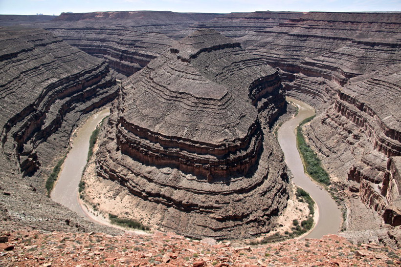
Why does the river make such a turn? Why didn't you wash the plateau directly?

And here - three turns in a row!

The two-level territory looks very strange. As if they removed the upper part of the soil, leaving the type of mesas. Or is it torn off by the waters of the flood?

The San Juan River is partly flat and partly canyon.

If this is an ancient quarry, then dumps are visible here (darker color of the soil). Or the remains of layers of soil.


Such examples can be given more (we will not touch the well-known Grand Canyon in Arizona).
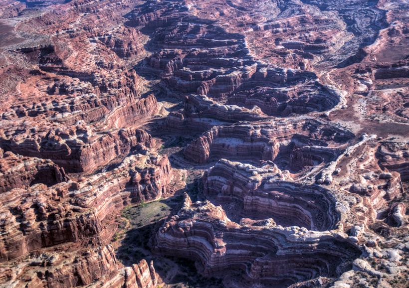
Canyonlands The Maze Aerial.

This landscape is generally difficult to explain.


It's hard to imagine what happened here. Where is all the soil that was level with the remnants of mesas?
I have looked at examples like this for a long time. Examples like this have often been sent to me as potential sites for the title of "ancient quarry". But I always have a share of doubts in any side of the issue. I remembered the meandering flat rivers.

Why don't lowland rivers flow straight? After all, straight is a movement with least work and resistance.
Figurative question in the picture.

River in the highlands of Peru


In these examples, it is clearly not the relief.

Official explanation:
Example: a river flows strictly straight on level ground. And suddenly, in the riverbed, there is some kind of heterogeneous place, which will lead to the fact that the river will bend a little due to erosion of the soil. Such a curvature will not be straightened, but will be further strengthened. Since under the new conditions the mass of water will move in an arc, a centripetal force will act on the water - this is the impact of the coast on the river. Accordingly, the water will act on the shore with exactly the same force - we recall Newton's third law. And since the water will act on the soil of the coast, the coast will begin to be washed away, thereby increasing the curvature of the channel.
In addition, water circulation occurs in the vertical plane in the mass of water, which leads to the transfer of earth particles from the outer (washed) coast to the inner one. This leads to the movement of the channel towards the outer bank, that is, to a greater curvature. By the way, that is why the inner bank, as a rule, is gentle and the river is shallow, while the river is much deeper near the outer bank.
It is worth noting that a similar movement of water is also observed in a glass of water - this explains why the tea leaves gather in the center of the bottom (which can be likened to the inner shore).
Thus, if you see a very straight and long section of the river, it was done artificially.
Confusing, like winding rivers. Here's more scientific explanation on video:
At the end of the speech, it was said: due to the speed of the current, a deep river will deepen more and more, and a shallow one will silt up. Everything is beautiful in this model. But most of all I liked the example of the meandering flow of water in this video:
Here, nothing interferes with the flow of water in the form of soil heterogeneities. But the stream still flows meandering like rivers.
Most of all in understanding these processes, Viktor Schauberger came up in his time. Here documentary about him: "Understand and imitate nature".
The above does not answer the question: why did the flow pass through the plateau? Especially in the Grand Canyon? The stream crosses the hill there. How is this possible? My explanation is that the washout was caused by flood water, or the rapid melting of the ice cap when the north pole was in North America. Only gigantic streams of water, hundreds of meters high, could do such a thing. However, the question is still that the flood waters would cover the territory and canyons. I will not rule out the version that there was an exit of the waters of the underground ocean under pressure, somewhere in this territory of the hill. Such water washed out the canyons, starting precisely from the hill, flowing down to the plain. Just like in the Bible: and the firmaments of heaven and earth opened up.
But the version of the ancient quarry-canyon cannot be discounted to the end. It also has reason to exist.
Here is my refutation of the version of ancient quarries, at least in relation to the Goosenecks canyon. As the saying goes: "Plato is my friend, but the truth is dearer..."
Article source: