What is a coordinate plane? Coordinate planes and graphs 1 coordinate plane
A rectangular coordinate system on a plane is formed by two mutually perpendicular coordinate axes X'X and Y'Y. The coordinate axes intersect at point O, which is called the origin of coordinates, a positive direction is chosen on each axis. The positive direction of the axes (in the right-handed coordinate system) is chosen so that when the X'X axis is rotated counterclockwise by 90 °, its positive direction coincides with the positive direction of the Y'Y axis. The four angles (I, II, III, IV) formed by the X'X and Y'Y coordinate axes are called coordinate angles (see Fig. 1).
The position of point A on the plane is determined by two coordinates x and y. The x-coordinate is equal to the length of the OB segment, the y-coordinate is the length of the OC segment in the selected units. Segments OB and OC are defined by lines drawn from point A parallel to the Y’Y and X’X axes, respectively. The x coordinate is called the abscissa of point A, the y coordinate is called the ordinate of point A. They write it like this: A (x, y).
If point A lies in coordinate angle I, then point A has positive abscissa and ordinate. If point A lies in coordinate angle II, then point A has a negative abscissa and a positive ordinate. If point A lies in coordinate angle III, then point A has negative abscissa and ordinate. If point A lies in coordinate angle IV, then point A has a positive abscissa and a negative ordinate.
Rectangular coordinate system in space is formed by three mutually perpendicular coordinate axes OX, OY and OZ. The coordinate axes intersect at the point O, which is called the origin, on each axis the positive direction indicated by the arrows is chosen, and the unit of measurement of the segments on the axes. The units of measure are the same for all axes. OX - abscissa axis, OY - ordinate axis, OZ - applicate axis. The positive direction of the axes is chosen so that when the OX axis is rotated counterclockwise by 90°, its positive direction coincides with the positive direction of the OY axis, if this rotation is observed from the side of the positive direction of the OZ axis. Such a coordinate system is called right. If the thumb of the right hand is taken as the X direction, the index finger as the Y direction, and the middle finger as the Z direction, then a right coordinate system is formed. Similar fingers of the left hand form the left coordinate system. The right and left coordinate systems cannot be combined so that the corresponding axes coincide (see Fig. 2).

The position of point A in space is determined by three coordinates x, y and z. The x coordinate is equal to the length of the segment OB, the y coordinate is equal to the length of the segment OC, the z coordinate is the length of the segment OD in the selected units. The segments OB, OC and OD are defined by planes drawn from point A parallel to the planes YOZ, XOZ and XOY, respectively. The x coordinate is called the abscissa of point A, the y coordinate is called the ordinate of point A, the z coordinate is called the applicate of point A. They write it like this: A (a, b, c).
Horts
A rectangular coordinate system (of any dimension) is also described by a set of orts , co-directed with the coordinate axes. The number of orts is equal to the dimension of the coordinate system, and they are all perpendicular to each other.
In the three-dimensional case, such vectors are usually denoted i j k or e x e y e z . In this case, in the case of the right coordinate system, the following formulas with the vector product of vectors are valid:
- [i j]=k ;
- [j k]=i ;
- [k i]=j .
Story
René Descartes was the first to introduce a rectangular coordinate system in his Discourse on the Method in 1637. Therefore, the rectangular coordinate system is also called - Cartesian coordinate system. The coordinate method for describing geometric objects laid the foundation for analytical geometry. Pierre Fermat also contributed to the development of the coordinate method, but his work was first published after his death. Descartes and Fermat used the coordinate method only on the plane.
Coordinate method for three-dimensional space was first used by Leonhard Euler in the 18th century.
see also
Links
Wikimedia Foundation. 2010 .
See what the "Coordinate plane" is in other dictionaries:
cutting plane- (Pn) Coordinate plane tangent to the cutting edge at the considered point and perpendicular to the base plane. […
In topography, a network of imaginary lines encircling Earth in the latitudinal and meridional directions, with which you can accurately determine the position of any point on the earth's surface. Latitudes are measured from the equator - a great circle, ... ... Geographic Encyclopedia
In topography, a network of imaginary lines encircling the globe in the latitudinal and meridional directions, with which you can accurately determine the position of any point on the earth's surface. Latitudes are measured from the equator of the great circle, ... ... Collier Encyclopedia
This term has other meanings, see Phase diagram. The phase plane is a coordinate plane in which any two variables (phase coordinates) are plotted along the coordinate axes, which uniquely determine the state of the system ... ... Wikipedia
principal cutting plane- (Pτ) Coordinate plane perpendicular to the line of intersection of the main plane and the cutting plane. [GOST 25762 83] Topics of cutting Generalizing terms systems of coordinate planes and coordinate planes … Technical Translator's Handbook
instrumental principal cutting plane- (Pτi) Coordinate plane perpendicular to the line of intersection of the instrumental main plane and the cutting plane. [GOST 25762 83] Topics of cutting Generalizing terms systems of coordinate planes and coordinate planes … Technical Translator's Handbook
tool cutting plane- (Pni) Coordinate plane tangent to the cutting edge at the point in question and perpendicular to the instrument base plane. [GOST 25762 83] Topics for cutting Generalizing terms for systems of coordinate planes and ... ... Technical Translator's Handbook
kinematic principal cutting plane- (Pτк) Coordinate plane perpendicular to the line of intersection of the kinematic main plane and the cutting plane ... Technical Translator's Handbook
kinematic cutting plane- (Pnk) Coordinate plane tangent to the cutting edge at the point under consideration and perpendicular to the kinematic base plane ... Technical Translator's Handbook
main plane- (Pv) A coordinate plane drawn through the considered point of the cutting edge perpendicular to the direction of the velocity of the main or net cutting motion at that point. Note In the instrumental coordinate system, the direction ... ... Technical Translator's Handbook
A rectangular coordinate system is a pair of perpendicular coordinate lines, called coordinate axes, that are placed so that they intersect at their origin.
The designation of the coordinate axes with the letters x and y is generally accepted, but the letters can be any. If the letters x and y are used, then the plane is called xy-plane. Different applications may use letters other than x and y, and as shown in the figures below, there are uv planes And ts-plane.

Ordered Pair
Under an ordered pair real numbers we mean two real numbers in a certain order. Each point P in the coordinate plane can be associated with a unique ordered pair of real numbers by drawing two lines through point P, one perpendicular to the x-axis and the other perpendicular to the y-axis.

For example, if we take (a,b)=(4,3), then on the coordinate strip

To build a point P(a,b) means to define a point with coordinates (a,b) on the coordinate plane. For example, various points are plotted in the figure below.

In a rectangular coordinate system, the coordinate axes divide the plane into four regions called quadrants. They are numbered counterclockwise with Roman numerals, as shown in the figure.

Graph definition
schedule equation with two variables x and y, is the set of points on the xy-plane, the coordinates of which are members of the set of solutions of this equation
Example: draw a graph y = x 2
Because 1/x is undefined when x=0, we can only plot points for which x ≠ 0

Example: Find all intersections with axes
(a) 3x + 2y = 6
(b) x = y 2 -2y
(c) y = 1/x
Let y = 0, then 3x = 6 or x = 2
is the required point of intersection of the x-axis.
Having established that x=0, we find that the point of intersection of the y-axis is the point y=3.
In this way you can solve equation (b), and the solutions for (c) are given below
x-crossing
Let y = 0
1/x = 0 => x cannot be determined, i.e. there is no intersection with the y-axis
Let x = 0
y = 1/0 => y is also undefined, => no intersection with the y-axis
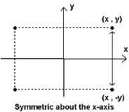
In the figure below, the points (x,y), (-x,y),(x,-y), and (-x,-y) represent the corners of the rectangle.

A graph is symmetrical about the x-axis if for each point (x,y) of the graph, the point (x,-y) is also a point on the graph.
A graph is symmetrical about the y-axis if for each graph point (x,y) the point (-x,y) also belongs to the graph.
A graph is symmetrical about the center of coordinates if for each point (x,y) of the graph, the point (-x,-y) also belongs to this graph.

Definition:
Schedule functions on the coordinate plane is defined as the graph of the equation y = f(x)
Plot f(x) = x + 2

Example 2. Plot f(x) = |x|
Graph coincides with the line y = x for x > 0 and with line y = -x
for x< 0 .


graph of f(x) = -x
Combining these two graphs, we get

graph f(x) = |x|
Example 3 Plot
t(x) \u003d (x 2 - 4) / (x - 2) \u003d
= ((x - 2)(x + 2)/(x - 2)) =
= (x + 2) x ≠ 2
Therefore, this function can be written as
y = x + 2 x ≠ 2
Graph h(x)= x 2 - 4 Or x - 2
plot y = x + 2 x ≠ 2
Example 4 Plot

Graphs of functions with displacement
Assume that the graph of the function f(x) is known
Then we can find graphs
y = f(x) + c - graph of the function f(x), moved
UP by c values
y = f(x) - c - graph of the function f(x), moved
DOWN by c values
y = f(x + c) - graph of the function f(x), moved
LEFT by c values
y = f(x - c) - graph of the function f(x), moved
Right by c values
Example 5. Build
graph y = f(x) = |x - 3| + 2
Move the graph y = |x| 3 values to the RIGHT to get the graph
Move the graph y = |x - 3| UP 2 values to plot y = |x - 3| + 2

Plot
y = x 2 - 4x + 5
We transform the given equation as follows, adding 4 to both parts:
y + 4 = (x 2 - 4x + 5) + 4 y = (x 2 - 4x + 4) + 5 - 4
y = (x - 2) 2 + 1
Here we see that this graph can be obtained by moving the graph y = x 2 to the right 2 values because x is 2 and up 1 value because +1.
y = x 2 - 4x + 5

Reflections
(-x, y) is the reflection of (x, y) about the y-axis
(x, -y) is the reflection of (x, y) about the x-axis
Plots y = f(x) and y = f(-x) are reflections of each other about the y-axis
Plots y = f(x) and y = -f(x) are reflections of each other about the x-axis
The graph can be obtained by reflection and translation:
draw a graph
Let's find its reflection relative to the y-axis, and get a graph
Move this graph right by 2 values and get a graph
Here is the desired graph

If f(x) is multiplied by a positive constant c, then
graph f(x) shrinks vertically if 0< c < 1
graph f(x) stretches vertically if c > 1

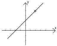
The curve is not a graph y = f(x) for any function f
On surface. Let one be x, the other y. And let these lines be mutually perpendicular (that is, intersect at a right angle). Moreover, the point of their intersection will be the origin of coordinates for both lines, and the unit segment is the same (Fig. 1).
So we got rectangular coordinate system, and our plane has become a coordinate. The lines x and y are called coordinate axes. Moreover, the x-axis is the abscissa axis, and the y-axis is the ordinate axis. Such a plane is usually designated by the name of the axes and the reference point - xOy. The rectangular coordinate system is also called Cartesian coordinate system, since for the first time it began to be actively used by the French mathematician and philosopher - Rene Descartes.
Right angles formed by lines x and y are called coordinate angles. Each corner has its own number as shown in fig. 2.

So, when we talked about the coordinate line, every point on this line had one coordinate. Now, when it comes to the coordinate plane, then each point of this plane will already have two coordinates. One corresponds to the line x (this coordinate is called abscissa), the other corresponds to the line y (this coordinate is called ordinate). It is written this way: M(x;y), where x is the abscissa and y is the ordinate. It reads as: "Point M with coordinates x, y."
How to determine the coordinates of a point on a plane?
Now we know that every point on the plane has two coordinates. In order to find out its coordinates, it is enough for us to draw two straight lines through this point, perpendicular to the coordinate axes. The points of intersection of these lines with the coordinate axes will be the desired coordinates. So, for example, in Fig. 3, we have determined that the coordinates of point M are 5 and 3.

How to construct a point on a plane by its coordinates?
It also happens that we already know the coordinates of a point on the plane. And we need to find its location. Let's say we have the coordinates of the point (-2; 5). That is, the abscissa is -2, and the ordinate is 5. Let's take a point with coordinate -2 on the x-line (abscissa axis) and draw a line a through it, parallel to the y-axis. Note that any point on this line will have an abscissa equal to -2. Now let's find a point with coordinate 5 on the y line (y-axis) and draw a line b through it, parallel to the x-axis. Note that any point on this line will have an ordinate equal to 5. At the intersection of lines a and b, there will be a point with coordinates (-2; 5). We denote it by the letter P (Fig. 4).

We also add that the line a, all points of which have abscissa -2, is given by the equation
x = -2 or that x = -2 is the equation of the line a. For convenience, we can say not “the straight line that is given by the equation x \u003d -2”, but simply “the straight line x \u003d -2”. Indeed, for any point of the line a, the equality x = -2 is true. And the straight line b, all points of which have ordinate 5, is in turn given by the equation y = 5, or that y = 5 is the equation of the straight line b.
§ 1 Coordinate system: definition and construction method
In this lesson, we will get acquainted with the concepts of "coordinate system", "coordinate plane", "coordinate axes", we will learn how to build points on the plane according to coordinates.
Take the coordinate line x with the origin point O, the positive direction and the unit segment.

Through the origin point O of the coordinate line x we draw another coordinate line y perpendicular to x, we set the positive direction upwards, the unit segment is the same. Thus, we have built a coordinate system.
Let's give a definition:
Two mutually perpendicular coordinate lines intersecting at the point, which is the origin of each of them, form a coordinate system.
§ 2 Coordinate axis and coordinate plane

The lines that form the coordinate system are called coordinate axes, each of which has its own name: the x coordinate line is the abscissa axis, the y coordinate line is the ordinate axis.
The plane on which the coordinate system is chosen is called the coordinate plane.

The described coordinate system is called rectangular. Often it is called the Cartesian coordinate system in honor of the French philosopher and mathematician René Descartes.
Each point of the coordinate plane has two coordinates, which can be determined by dropping the perpendiculars on the coordinate axis from the point. The coordinates of a point on the plane are a pair of numbers, of which the first number is the abscissa, the second number is the ordinate. The abscissa shows the perpendicular to the x-axis, the ordinate shows the perpendicular to the y-axis.

We mark point A on the coordinate plane, draw perpendiculars from it to the axes of the coordinate system.
Along the perpendicular to the abscissa axis (x axis), we determine the abscissa of point A, it is equal to 4, the ordinate of point A - along the perpendicular to the ordinate axis (y axis) is 3. The coordinates of our point are 4 and 3. A (4; 3). Thus, coordinates can be found for any point in the coordinate plane.
§ 3 Construction of a point on a plane
And how to build a point on a plane with given coordinates, i.e. determine its position from the coordinates of a point in a plane? IN this case perform the steps in reverse order. On the coordinate axes we find the points corresponding to the given coordinates, through which we draw straight lines perpendicular to the x and y axes. The intersection point of the perpendiculars will be the desired one, i.e. point with given coordinates.

Let's complete the task: build a point M (2; -3) on the coordinate plane.
To do this, on the x-axis we find a point with coordinate 2, draw through given point straight line perpendicular to the x-axis. On the y-axis we find a point with coordinate -3, through it we draw a line perpendicular to the y-axis. The point of intersection of the perpendicular lines will be the given point M.
Now let's look at a few special cases.
We mark points A (0; 2), B (0; -3), C (0; 4) on the coordinate plane.

The abscissas of these points are equal to 0. The figure shows that all points are on the y-axis.
Therefore, points whose abscissas are equal to zero lie on the y-axis.
Let's swap the coordinates of these points.

Get A (2; 0), B (-3; 0) C (4; 0). In this case, all ordinates are 0 and the points are on the x-axis.
This means that points whose ordinates are equal to zero lie on the abscissa axis.
Let's consider two more cases.
On the coordinate plane, mark the points M (3; 2), N (3; -1), P (3; -4).

It is easy to see that all the abscissas of the points are the same. If these points are connected, you get a straight line parallel to the ordinate axis and perpendicular to the abscissa axis.
The conclusion suggests itself: points that have the same abscissa lie on the same straight line, which is parallel to the ordinate axis and perpendicular to the abscissa axis.
If we change the coordinates of the points M, N, P in places, then we get M (2; 3), N (-1; 3), P (-4; 3). The ordinates of the points will become the same. In this case, if you connect these points, you get a straight line parallel to the abscissa axis and perpendicular to the ordinate axis.
Thus, points having the same ordinate lie on the same straight line parallel to the abscissa axis and perpendicular to the ordinate axis.
In this lesson, you got acquainted with the concepts of "coordinate system", "coordinate plane", "coordinate axes - the abscissa axis and the y-axis". We learned how to find the coordinates of a point on a coordinate plane and learned how to build points on a plane by its coordinates.
List of used literature:
- Mathematics. Grade 6: lesson plans for the textbook by I.I. Zubareva, A.G. Mordkovich // author-compiler L.A. Topilin. – Mnemosyne, 2009.
- Mathematics. Grade 6: student textbook educational institutions. I.I. Zubareva, A.G. Mordkovich.- M.: Mnemozina, 2013.
- Mathematics. Grade 6: textbook for educational institutions / G.V. Dorofeev, I.F. Sharygin, S.B. Suvorov and others / edited by G.V. Dorofeeva, I.F. Sharygin; Russian Academy of Sciences, Russian Academy of Education. - M.: "Enlightenment", 2010
- Mathematics Handbook - http://lyudmilanik.com.ua
- Handbook for students in high school http://shkolo.ru
The text of the work is placed without images and formulas.
Full version work is available in the "Files of work" tab in PDF format
Introduction
In the speech of adults, you could hear the following phrase: "Leave me your coordinates." This expression means that the interlocutor must leave his address or phone number by which he can be found. Those of you who have played "sea battle" used the appropriate coordinate system. A similar coordinate system is used in chess. The seats in the auditorium of the cinema are given by two numbers: the first number indicates the number of the row, and the second is the number of the seat in this row. The idea of specifying the position of a point on a plane using numbers originated in antiquity. The coordinate system permeates the entire practical life human and has a huge practical application. Therefore, we decided to create this project in order to expand our knowledge on the topic "Coordinate plane"
Project objectives:
get acquainted with the history of the emergence of a rectangular coordinate system on a plane;
eminent figures dealing with this topic;
find interesting historical facts;
well perceive the coordinates by ear; carry out constructions clearly and accurately;
prepare a presentation.
Chapter I. Coordinate plane
The idea to set the position of a point on a plane using numbers originated in antiquity - primarily among astronomers and geographers when compiling star and geographical maps, calendars.
§1. Origin of coordinates. Coordinate system in geography
For 200 years BC, the Greek scientist Hipparchus introduced geographical coordinates. He offered to draw geographical map parallels and meridians and indicate latitude and longitude with numbers. Using these two numbers, you can accurately determine the position of an island, village, mountain or well in the desert and put them on a map or globe. By learning to determine the latitude and longitude of the location of the ship in the open world, sailors were able to choose the direction they needed.
East longitude and north latitude are indicated by numbers with a plus sign, and west longitude and south latitude are indicated by minus signs. Thus, a pair of numbers with signs uniquely defines a point on the globe.
Geographic latitude? - the angle between the plumb line at a given point and the plane of the equator, counted from 0 to 90 in both directions from the equator. Geographic longitude? - the angle between the plane of the meridian passing through the given point and the plane of the beginning of the meridian (see Greenwich meridian). Longitudes from 0 to 180 to the east of the beginning of the meridian are called eastern, to the west - western.
To find some object in the city, in most cases it is enough to know its address. Difficulties arise if you need to explain where, for example, a summer cottage, a place in the forest is located. Geographic coordinates serve as a universal means of specifying a location.
When getting into an emergency, a person must first of all be able to navigate the terrain. Sometimes it is necessary to determine the geographical coordinates of your location, for example, to transfer to the rescue service or for other purposes.
In modern navigation, the world coordinate system WGS-84 is used as standard. All GPS navigators and major mapping projects on the Internet work in this coordinate system. Coordinates in the WGS-84 system are as commonly used and understood by everyone as universal time. Public accuracy when working with geographic coordinates is 5 - 10 meters on the ground.
Geographical coordinates are signed numbers (latitude from -90° to +90°, longitude from -180° to +180°) and can be written in various forms: in degrees (ddd.ddddd°); degrees and minutes (ddd° mm.mmm"); degrees, minutes and seconds (ddd° mm" ss.s"). Recording forms can be easily converted one into another (1 degree = 60 minutes, 1 minute = 60 seconds) To indicate the sign of the coordinates, letters are often used, by the name of the cardinal points: N and E - northern latitude and eastern longitude - positive numbers, S and W - southern latitude and western longitude - negative numbers.
The form of writing coordinates in DEGREES is the most convenient for manual entry and coincides with the mathematical notation of a number. The DEGREES AND MINUTES form of coordinates is the preferred format in many cases, it is the default format in most GPS navigators and is the standard used in aviation and at sea. The classical form of writing coordinates in DEGREES, MINUTES AND SECONDS does not really find much practical use.
§2. Coordinate system in astronomy. Myths about constellations
As mentioned above, the idea to set the position of a point on a plane using numbers originated in ancient times among astronomers when compiling star maps. People needed to count time, predict seasonal phenomena (tides, tides, seasonal rains, floods), they had to navigate the terrain while traveling.
Astronomy is the science of stars, planets, celestial bodies, their structure and development.
Thousands of years have passed, science has stepped far forward, and a person still cannot tear his admiring glance from the beauty of the night sky.
Constellations are sections of the starry sky, characteristic figures formed by bright stars. The entire sky is divided into 88 constellations, which make it easier to navigate among the stars. Most of the constellation names come from antiquity.
The most famous constellation is Ursa Major. IN Ancient Egypt it was called “Hippo”, and the Kazakhs called it “Horse on a leash”, although outwardly the constellation does not resemble any one or another animal. What is it?
The ancient Greeks had a legend about the constellations Ursa Major and Ursa Minor. The almighty god Zeus decided to marry the beautiful nymph Calisto, one of the servants of the goddess Aphrodite, against the wishes of the latter. To save Calisto from the persecution of the goddess, Zeus turned Calisto into Ursa Major, her beloved dog into Ursa Minor and took them to heaven. Transfer the constellations Ursa Major and Ursa Minor from the starry sky to the coordinate plane. . Each of the stars of the Ursa Major Bucket has its own name.
THE BIG BEAR
I recognize by the BUCKET!
Seven stars sparkle here
And here's what they're called:
DUBHE illuminates the darkness,
MERAK burns next to him,
On the side is FEKDA with MEGRETS,
A cheeky young man.
From Megrets for departure
ALIOT is located,
And behind him - MITSAR with ALCOR
(These two shine in chorus).
Closes our bucket
Incomparable BENETNASH.
He points to the eye
The path to the constellation BOOTES,
Where the beautiful ARCTUR shines,
Everyone will notice it now!
No less beautiful legend about the constellations Cepheus, Cassiopeia and Andromeda.
Ethiopia was once ruled by King Cepheus. Once his wife, Queen Cassiopeia, had the imprudence to boast of her beauty in front of the inhabitants of the sea - the Nereids. The latter, offended, complained to the god of the sea, Poseidon, and the ruler of the seas, enraged by the audacity of Cassiopeia, released a sea monster, Kita, onto the shores of Ethiopia. In order to save his kingdom from destruction, Cepheus, on the advice of the oracle, decided to sacrifice to the monster and give him his beloved daughter Andromeda to be eaten. He chained Andromeda to a coastal rock and left her to await the decision of her fate.
Meanwhile, on the other side of the world, the mythical hero Perseus accomplished a daring feat. He penetrated a secluded island where gorgons lived - amazing monsters in the form of women with snakes on their heads instead of hair. The look of the gorgons was so terrible that everyone they looked at instantly turned into stone.
Taking advantage of the sleep of these monsters, Perseus cut off the head of one of them, the Gorgon Medusa. At that moment, the horse Pegasus fluttered out of the severed body of Medusa. Perseus grabbed the head of a medusa, jumped on Pegasus and rushed through the air to his homeland. When he flew over Ethiopia, he saw Andromeda chained to a rock. At this moment, the Whale has already emerged from the depths of the sea, preparing to swallow its prey. But Perseus, rushing into a mortal battle with Keith, defeated the monster. He showed Keith the head of a jellyfish that had not yet lost its strength, and the monster petrified, turning into an island. As for Perseus, having unchained Andromeda, he returned her to her father, and Cepheus, touched by happiness, gave Andromeda as his wife to Perseus. So this story ended happily, the main characters of which were placed by the ancient Greeks in heaven.
On the star map you can find not only Andromeda with her father, mother and husband, but also the magic horse Pegasus and the culprit of all troubles - the monster Kita.
The constellation Cetus is located below Pegasus and Andromeda. Unfortunately, it is not marked by any characteristic bright stars and therefore belongs to the number of minor constellations.
§3. Using the idea of rectangular coordinates in painting.
Traces of applying the idea of rectangular coordinates in the form of a square grid (pallet) are depicted on the wall of one of the burial chambers of Ancient Egypt. In the burial chamber of the pyramid of the father of Ramses, there is a network of squares on the wall. With their help, the image was transferred in an enlarged form. Rectangular grids were also used by Renaissance artists.
The word "perspective" in Latin means "clearly see." IN fine arts linear perspective is the image of objects on a plane in accordance with the apparent changes in their size. The basis of modern perspective theory was laid by the great artists of the Renaissance - Leonardo da Vinci, Albrecht Dürer and others. One of Durer's engravings (Fig. 3) shows a method of drawing from life through glass with a square grid applied to it. This process can be described as follows: if you stand in front of the window and, without changing your point of view, circle everything that is visible behind it on the glass, then the resulting drawing will be a perspective image of space.
Egyptian design methods that seem to have been based on square grid patterns. There are numerous examples in Egyptian art showing that painters and sculptors first drew a grid on the wall, which was to be painted or carved in order to maintain the established proportions. The simple numerical ratios of these grids are at the core of all great works of art Egyptians.
The same method was used by many Renaissance artists, including Leonardo da Vinci. In ancient Egypt, this was embodied in the Great Pyramid, which is reinforced by its close connection with the pattern on Marlborough Down.
Getting to work, the Egyptian artist drew a grid of straight lines on the wall and then carefully transferred the figures onto it. But geometric order did not prevent him from recreating nature with detailed accuracy. The appearance of each fish, each bird is conveyed with such truthfulness that modern zoologists can easily determine their species. Figure 4 shows a detail of the composition from the illustration - a tree with birds caught in Khnumhotep's net. The movement of the artist's hand was guided not only by the reserves of his skills, but also by an eye sensitive to the outlines of nature.
Fig.4 Birds on acacia
Chapter II. Method of coordinates in mathematics
§1. Application of coordinates in mathematics. Merits
French mathematician René Descartes
For a long time only geography "description of land" used this wonderful invention, and only in the 14th century the French mathematician Nicolas Orem (1323-1382) tried to apply it to "land measurement" - geometry. He proposed to cover the plane with a rectangular grid and call latitude and longitude what we now call the abscissa and ordinate.
Based on this successful innovation, the method of coordinates arose, linking geometry with algebra. The main merit in the creation of this method belongs to the great French mathematician René Descartes (1596 - 1650). In his honor, such a coordinate system is called Cartesian, denoting the location of any point in the plane by the distances from this point to the "zero latitude" - the abscissa axis "and the "zero meridian" - the ordinate axis.
However, this brilliant French scientist and thinker of the 17th century (1596 - 1650) did not immediately find his place in life. Born into a noble family, Descartes received a good education. In 1606, his father sent him to the Jesuit College of La Fleche. Considering Descartes' not very good health, he was given some indulgences in the strict regime of this educational institution For example, they were allowed to get up later than others. Having acquired a lot of knowledge in the college, Descartes at the same time was imbued with an antipathy for scholastic philosophy, which he retained throughout his life.
After graduating from the college, Descartes continued his education. In 1616, at the University of Poitiers, he received a bachelor's degree in law. In 1617 Descartes joined the army and traveled extensively in Europe.
1619 scientifically proved to be a key year for Descartes.
It was at this time, as he himself wrote in his diary, that the foundations of a new " amazing science". Most likely, Descartes had in mind the discovery of the universal scientific method, which he later fruitfully applied in a variety of disciplines.
In the 1620s, Descartes met the mathematician M. Mersenne, through whom he “kept in touch” with the entire European scientific community for many years.
In 1628, Descartes settled in the Netherlands for more than 15 years, but did not settle in any one place, but changed his place of residence about two dozen times.
In 1633, having learned about the condemnation of Galileo by the church, Descartes refuses to publish the natural-philosophical work The World, which outlined the ideas of the natural origin of the universe according to the mechanical laws of matter.
In 1637 on French Descartes' Discourse on Method is published, with which, as many believe, modern European philosophy began.
The last philosophical work of Descartes, The Passions of the Soul, published in 1649, also had a great influence on European thought. In the same year, at the invitation of Swedish queen Christina Descartes went to Sweden. The harsh climate and unusual regime (the queen forced Descartes to get up at 5 in the morning to give her lessons and carry out other tasks) undermined Descartes' health, and, having caught a cold, he
died of pneumonia.
According to the tradition introduced by Descartes, the "latitude" of a point is denoted by the letter x, "longitude" - by the letter y
Many ways of specifying a place are based on this system.
For example, there are two numbers on a ticket to a cinema: a row and a seat - they can be considered as the coordinates of a seat in the hall.
Similar coordinates are accepted in chess. Instead of one of the numbers, a letter is taken: the vertical rows of cells are denoted by letters of the Latin alphabet, and the horizontal rows by numbers. Thus, each cell of the chessboard is assigned a pair of letters and numbers, and chess players get the opportunity to write down their games. Konstantin Simonov writes about the use of coordinates in his poem "The Son of an Artilleryman".
All night, walking like a pendulum
Major did not close his eyes,
While on the radio in the morning
The first signal came:
"It's okay, got it,
Germans left me
Coordinates (3;10),
Rather, let's fire!
The guns were loaded
The major calculated everything himself.
And with a roar the first volleys
They hit the mountains.
And again the signal on the radio:
"Germans right me,
Coordinates (5; 10),
More fire!
Earth and rocks flew
A column of smoke rose.
It seemed that now from there
Nobody gets out alive.
The third signal on the radio:
"Germans around me,
Coordinates (4; 10),
Don't spare the fire.
The Major turned pale when he heard:
(4;10) - just
The place where his Lyonka
Must sit now.
Konstantin Simonov "Son of an artilleryman"
§2. Legends about the invention of the coordinate system
There are several legends about the invention of the coordinate system that bears the name of Descartes.
Legend 1
Such a story has come down to our times.
Visiting the Parisian theaters, Descartes never tired of being surprised at the confusion, squabbles, and sometimes challenges to a duel caused by the lack of an elementary order of distribution of the audience in the auditorium. The numbering system he proposed, in which each place received a row number and a serial number from the edge, immediately removed all occasions for contention and made a splash in Parisian high society.
Legend2. Once Rene Descartes lay in bed all day, thinking about something, and a fly buzzed around and did not allow him to concentrate. He began to think about how to describe the position of the fly at any given time mathematically so that he could swat it without a miss. And ... came up with, Cartesian coordinates, one of the greatest inventions in the history of mankind.
Markovtsev Yu.
Once upon a time in an unfamiliar city
The young Descartes arrived.
He was terribly hungry.
It was a chilly month of March.
Decided to turn to a passerby
Descartes, trying to calm the trembling:
Where is the hotel, please?
And the lady began to explain:
- Go to the dairy
Then to the bakery, behind it
Gypsy sells pins
And poison for rats and for mice,
Find them for sure
Cheeses, biscuits, fruits
And colorful silks...
I listened to all these explanations
Descartes, shivering from the cold.
He really wanted to eat
- Behind the shops is a pharmacy
(the pharmacist there is a mustachioed Swede),
And the church, where at the beginning of the century
Married, it seems, my grandfather ...
When the lady fell silent for a moment,
Suddenly her servant said:
- Walk three blocks straight
And two to the right. Entrance from the corner.
This is the third tall tale about the event that gave Descartes the idea of coordinates.
Conclusion
While creating our project, we learned about the use of the coordinate plane in various fields of science and Everyday life, some information from the history of the origin of the coordinate plane and mathematicians who made a great contribution to this invention. The material that we have collected in the course of writing the work can be used in the classroom of the school circle, as additional material to the lessons. All this can interest students and brighten up the learning process.
And we would like to end with these words:
“Imagine your life as a coordinate plane. The y-axis is your position in society. The x-axis is moving forward, towards the goal, towards your dream. And as we know, it is infinite… we can fall down, going deeper and deeper into minus, we can stay at zero and do nothing, absolutely nothing. We can rise up, we can fall, we can go forward or go back, and all because our whole life is a coordinate plane and the most important thing here is what is your coordinate ... "
Bibliography
Glazer G.I. History of mathematics at school: - M.: Education, 1981. - 239 p., ill.
Lyatker Ya. A. Descartes. M .: Thought, 1975. - (Thinkers of the past)
Matvievskaya G. P. Rene Descartes, 1596-1650. Moscow: Nauka, 1976.
A. Savin. Coordinates Quantum. 1977. No. 9
Mathematics - supplement to the newspaper "The First of September", No. 7, No. 20, No. 17, 2003, No. 11, 2000.
Siegel F.Yu. Star alphabet: A guide for students. - M.: Enlightenment, 1981. - 191 p., Illus.
Steve Parker, Nicholas Harris. Illustrated encyclopedia for children. Secrets of the universe. Kharkov Belgorod. 2008
Materials from the site http://istina.rin.ru/