Lithosphere, its composition and structure briefly. According to scientific research, scientists have been able to establish that the lithosphere consists of. The structure of the lithosphere. Concept of tectonic plates
The lithosphere is the rocky shell of the Earth. From the Greek “lithos” - stone and “sphere” - ball
The lithosphere is the outer solid shell of the Earth, which includes the entire Earth's crust with part of the Earth's upper mantle and consists of sedimentary, igneous and metamorphic rocks. The lower boundary of the lithosphere is unclear and is determined by a sharp decrease in the viscosity of rocks, a change in the speed of propagation of seismic waves and an increase in the electrical conductivity of rocks. The thickness of the lithosphere on continents and under oceans varies and averages 25 - 200 and 5 - 100 km, respectively.
Let us consider in general terms the geological structure of the Earth. The third planet beyond the distance from the Sun, Earth, has a radius of 6370 km, an average density of 5.5 g/cm3 and consists of three shells - bark, mantle and and. The mantle and core are divided into internal and external parts.

The Earth's crust is the thin upper shell of the Earth, which is 40-80 km thick on the continents, 5-10 km under the oceans and makes up only about 1% of the Earth's mass. Eight elements - oxygen, silicon, hydrogen, aluminum, iron, magnesium, calcium, sodium - form 99.5% of the earth's crust.
According to scientific research, scientists were able to establish that the lithosphere consists of:
- Oxygen – 49%;
- Silicon – 26%;
- Aluminum – 7%;
- Iron – 5%;
- Calcium – 4%
- The lithosphere contains many minerals, the most common being spar and quartz.
On continents, the crust is three-layered: sedimentary rocks cover granite rocks, and granite rocks overlie basaltic rocks. Under the oceans the crust is “oceanic”, of a two-layer type; sedimentary rocks simply lie on basalts, there is no granite layer. There is also a transitional type of the earth's crust (island-arc zones on the margins of the oceans and some areas on continents, for example the Black Sea).

The earth's crust is thickest in mountainous regions(under the Himalayas - over 75 km), the average - in the areas of the platforms (under the West Siberian Lowland - 35-40, within the borders of the Russian Platform - 30-35), and the smallest - in the central regions of the oceans (5-7 km). The predominant part of the earth's surface is the plains of the continents and the ocean floor.
The continents are surrounded by a shelf - a shallow strip with a depth of up to 200 g and an average width of about 80 km, which, after a sharp steep bend of the bottom, turns into a continental slope (the slope varies from 15-17 to 20-30°). The slopes gradually level out and turn into abyssal plains (depths 3.7-6.0 km). The oceanic trenches have the greatest depths (9-11 km), the vast majority of which are located on the northern and western edges of the Pacific Ocean.
The main part of the lithosphere consists of igneous igneous rocks (95%), among which granites and granitoids predominate on the continents, and basalts in the oceans.
Lithosphere blocks - lithospheric plates- move along a relatively plastic asthenosphere. The section of geology on plate tectonics is devoted to the study and description of these movements.
To designate the outer shell of the lithosphere, the now obsolete term sial was used, derived from the name of the main rock elements Si (Latin: Silicium - silicon) and Al (Latin: Aluminum - aluminum).
Lithospheric plates

It is worth noting that the largest tectonic plates are very clearly visible on the map and they are:
- Pacific- the largest plate on the planet, along the boundaries of which constant collisions of tectonic plates occur and faults form - this is the reason for its constant decrease;
- Eurasian– covers almost the entire territory of Eurasia (except for Hindustan and the Arabian Peninsula) and contains the largest part of the continental crust;
- Indo-Australian– it includes the Australian continent and the Indian subcontinent. Due to constant collisions with the Eurasian plate, it is in the process of breaking;
- South American– consists of the South American continent and part of the Atlantic Ocean;
- North American– consists of the North American continent, part of northeastern Siberia, the northwestern part of the Atlantic and half of the Arctic oceans;
- African– consists of the African continent and the oceanic crust of the Atlantic and Indian oceans. Interestingly, the plates adjacent to it move in the opposite direction from it, so the largest fault on our planet is located here;
- Antarctic plate– consists of the continent of Antarctica and the nearby oceanic crust. Due to the fact that the plate is surrounded by mid-ocean ridges, the remaining continents are constantly moving away from it.
Movement of tectonic plates in the lithosphere
Lithospheric plates, connecting and separating, constantly change their outlines. This allows scientists to put forward the theory that about 200 million years ago the lithosphere had only Pangea - a single continent, which subsequently split into parts, which began to gradually move away from each other at a very low speed (on average about seven centimeters per year ).
This is interesting! There is an assumption that, thanks to the movement of the lithosphere, in 250 million years a new continent will form on our planet due to the unification of moving continents.
When the oceanic and continental plates collide, the edge of the oceanic crust subducts under the continental crust, while on the other side of the oceanic plate its boundary diverges from the adjacent plate. The boundary along which the movement of lithospheres occurs is called the subduction zone, where the upper and subducting edges of the plate are distinguished. It is interesting that the plate, plunging into the mantle, begins to melt when the upper part of the earth’s crust is compressed, as a result of which mountains are formed, and if magma also erupts, then volcanoes.
In places where tectonic plates come into contact with each other, zones of maximum volcanic and seismic activity are located: during the movement and collision of the lithosphere, the earth's crust is destroyed, and when they diverge, faults and depressions are formed (the lithosphere and the Earth's topography are connected to each other). This is the reason that the Earth's largest landforms—mountain ranges with active volcanoes and deep-sea trenches—are located along the edges of tectonic plates.
Lithosphere problems
The intensive development of industry has led to the fact that man and the lithosphere have recently begun to get along extremely poorly with each other: the pollution of the lithosphere is acquiring catastrophic proportions. This happened due to the increase in industrial waste combined with household waste and fertilizers and pesticides used in agriculture, which negatively affects chemical composition soil and living organisms. Scientists have calculated that about one ton of garbage is generated per person per year, including 50 kg of hard-to-degrade waste.

Today, lithosphere pollution has become actual problem, since nature is not able to cope with it on its own: the self-cleaning of the earth’s crust occurs very slowly, and therefore harmful substances gradually accumulate and, over time, negatively affect the main culprit of the problem - humans.
Internal structure of the Earth. It is customary to divide the Earth's body into three main parts - the lithosphere (earth's crust), the mantle and the core.
Core, with an average radius of about 3500 km, is believed to consist of iron mixed with silicon. The outer part of the core is in a molten state, the inner part is apparently solid.
The core is replaced mantle, which extends for almost 3000 km. It is believed to be hard, but at the same time plastic and hot.
Lithosphere- the upper shell of the “solid” Earth, including the earth’s crust and the upper part of the underlying upper mantle of the Earth.
Earth's crust– the upper shell of the “solid” Earth. The thickness of the earth's crust ranges from 5 km (under the oceans) to 75 km (under the continents). The earth's crust is heterogeneous. There are 3 layers in it - sedimentary, granite, basalt. Granite and basalt layers are so named because they contain rocks that are similar in physical properties on granite and basalt.
Distinguish continental And oceanic the earth's crust. The oceanic one differs from the continental one in the absence of a granite layer and a significantly smaller thickness (from 5 to 10 km).
The position of the layers in the continental crust indicates different times of its formation. The basalt layer is the oldest, younger than it is the granite layer, and the youngest is the upper, sedimentary layer, which is still developing today. Each layer of crust was formed over a long period of geological time.
Rocks- the main substance that makes up the earth's crust. Solid or loose compound of minerals. Based on their origin, rocks are divided into three groups:
1) igneous – are formed as a result of solidification of magma in the earth’s crust or on the surface. Highlight:
A) intrusive(formed in the thickness of the earth's crust, for example, granites);
b) effusive(formed by the outpouring of magma onto the surface, for example, basalts).
2) sedimentary – are formed on the surface of land or in bodies of water as a result of the accumulation of destruction products of pre-existing rocks of various origins. Sedimentary rocks cover about 75% of the surface of the continents. Among the sedimentary rocks are:
A) clastic– formed from various minerals and rock fragments during their transport and redeposition (by flowing water, wind, glacier). For example: crushed stone, pebbles, sand, clay; the largest fragments are boulders and blocks;
b) chemical– are formed from water-soluble substances (potassium salt, table salt, etc.);
V) organic(or biogenic) - consist of the remains of plants and animals or of minerals formed as a result of the vital activity of organisms (limestone-shell rock, chalk, fossil coals);
3) metamorphic – are obtained by changing other types of rocks under the influence of heat and pressure in the depths of the earth’s crust (quartzites, marble).
Minerals– natural mineral formations in the earth’s crust of inorganic and organic origin, which, at a given level of technological and economic development, can be used in the economy in their natural form or after appropriate processing. Minerals are classified according to many criteria. For example, they distinguish solid (coal, metal ores), liquid (oil, mineral water) and gaseous (combustible natural gases) minerals.
According to composition and features of use usually distinguished:
a) fossil fuels – coal, oil, natural gas, oil shale, peat;
b) metallic – ores of ferrous, non-ferrous, noble and other metals;
c) non-metallic minerals - limestone, rock salt, gypsum, mica, etc.
According to the method of formation, minerals can be:
1) endogenous, the formation of which is associated with an eruption or outpouring of magma;
2) exogenous, arising through the accumulation of sedimentary rocks;
3) metamorphic, formed under high pressure or when hot lava comes into contact with sedimentary rocks.
Sometimes by origin There are two groups: ore And nonmetallic(sedimentary) minerals. The characteristics of the distribution of minerals on Earth are closely related to their origin.
Lithospheric plates– large rigid blocks of the Earth’s lithosphere, bounded by seismically and tectonically active fault zones.
The plates, as a rule, are separated by deep faults and move through the viscous layer of the mantle relative to each other at a speed of 2-3 cm per year. Where continental plates converge, they collide and mountain belts are formed. When the continental and oceanic plates interact, the plate with the oceanic crust is pushed under the plate with the continental crust, resulting in the formation of deep-sea trenches and island arcs.
The movement of lithospheric plates is associated with the movement of matter in the mantle. In certain parts of the mantle there are powerful flows of heat and matter rising from its depths to the surface of the planet.
Rift– a huge fracture in the earth's crust, formed during its horizontal stretching (i.e., where the flows of heat and matter diverge).
In rifts, magma outflows, new faults, horsts, and grabens arise. Mid-ocean ridges form.
Mid-ocean ridges- powerful underwater mountain structures within the ocean floor, most often occupying a middle position. Near mid-ocean ridges, lithospheric plates move apart and young basaltic oceanic crust appears. The process is accompanied by intense volcanism and high seismicity.
Continental rift zones are, for example, the East African Rift System, the Baikal Rift System. Rifts, like mid-ocean ridges, are characterized by seismic activity and volcanism.
Plate tectonics is a hypothesis that suggests that the lithosphere is broken into large plates that move horizontally through the mantle. Near mid-ocean ridges, lithospheric plates move apart and grow due to matter rising from the bowels of the Earth; in deep-sea trenches, one plate moves under another and is absorbed by the mantle. Fold structures are formed where plates collide.
Seismic belts of the Earth. The moving areas of the Earth are the boundaries of lithospheric plates (places of their rupture and divergence, collision), i.e. these are rift zones on land, as well as mid-ocean ridges and deep-sea trenches in the ocean. These areas experience frequent volcanic eruptions and earthquakes. This is explained by the emerging tension in the earth's crust and indicates that the process of formation of the earth's crust in these zones is intensively ongoing.
Thus, zones of modern volcanism and high seismic activity (i.e., the spread of earthquakes) coincide with faults in the earth's crust.
Regions where earthquakes occur are called seismic.
External and internal forces that change the surface of the Earth. Relief– a set of irregularities on the earth’s surface. The formation of relief is simultaneously influenced by external and internal forces, giving rise to many geological processes.
Processes that change the Earth's surface are divided into two groups:
1) internal processes - tectonic movements, earthquakes, volcanism. The source of energy for these processes is the internal energy of the Earth;
2) external processes - weathering (physical, chemical, biological), wind activity, surface flowing water activity, glacier activity. The source of energy is solar heat.
Internal processes of relief formation (endogenous). Tectonic movements – mechanical movements of the earth's crust caused by forces acting in the earth's crust and mantle. Lead to significant changes in relief. Tectonic movements vary in form, depth and causes. Tectonic movements are divided into oscillatory (slow vibrations of the earth's crust), folded and discontinuous (formation of cracks, grabens, horsts). Based on time, they are distinguished as ancient (before the Cenozoic folding), newest (starting from the Neogene period) and modern. The newest and modern ones are sometimes combined into Neo-Quaternary movements.
Neogene-Quaternary movements of the earth's crust. These include tectonic processes of the Neogene-Quaternary period (the last 30 million years), which covered all geostructures and determined the basic appearance of the modern relief. In modern times, the movements of many previously formed large landforms continue - hills and mountain ranges rise, and certain parts of the lowlands descend and are filled with sediment.
Earthquakes. Earthquakes are called tremors of the earth's surface caused by natural causes. Depending on the reasons causing earthquakes, they are divided into 3 types:
1) tectonic earthquakes associated with the formation of faults in the earth's crust and the movement of blocks of the earth's crust along them. Tectonic earthquakes are the most common;
2) volcanic earthquakes associated with the movements of magma in the source and channel of the volcano and explosive emissions of volcanic gases.
Typically, volcanic earthquakes occur with little force and cover small areas. In some cases, the force of such earthquakes can be enormous - during the eruption of the Krakatau volcano (Sunda Islands) in 1883, the explosion destroyed half of the volcano, and the shaking caused great destruction on the islands of Java, Sumatra, Kalimantan;
3) landslide earthquakes that occur during a collapse in underground voids due to the impact produced by the collapsed mass. This type of earthquake occurs infrequently and has little strength; spread over a very limited area.
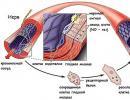
There are about 100,000 earthquakes on Earth during the year, or about 300 per day. Earthquakes usually occur quickly, within a few seconds or even fractions of seconds. The area within the Earth's interior within which an earthquake occurs is called the source of the earthquake, its center is hypocenter, and the projection of the hypocenter onto the Earth’s surface is epicenter. The sources of earthquakes can be located at depths from 20-30 km to 500-600 km. The most powerful earthquakes had a focal depth of 10-15 to 20-25 km. Earthquakes with a deep source are usually not very destructive on the surface.
The strength of earthquakes is determined on a 12-point scale. One point indicates the weakest earthquake, the strongest, 10-12 points, have catastrophic consequences. Earthquakes are recorded by special instruments - seismographs. The science that studies the causes of earthquakes, their consequences, the connection of earthquakes with tectonic processes and the possibility of their prediction is called seismology .
One of the main tasks is earthquake prediction, i.e. forecasting where, when and what strength an earthquake will occur. This can be determined using a seismic zoning map.
Seismic zoning– dividing the territory into regions according to their seismic activity, assessing and displaying on maps the potential seismic hazard, which must be taken into account during earthquake-resistant construction.
In Russia, strong earthquakes are possible in the Baikal region, Kamchatka, the Kuril Islands, and Southern Siberia.
In the world there is a Pacific seismic belt surrounding Pacific Ocean, and the Mediterranean, running from the Atlantic Ocean through Central Asia to the Pacific. The active seismic belt passing through East Africa, the Red Sea, Tien Shan, the Baikal basin, and the Stanovoy Range is much younger.
Thus, most earthquakes are confined to the margins of lithospheric plates, to the places of their interaction. There is a significant connection between earthquakes and volcanism.
Volcanism– a set of processes and phenomena associated with the outpouring of magma onto the earth’s surface.
Magma– molten material of rocks and minerals, a mixture of many components. Magma always contains volatile substances: water vapor, carbon dioxide, hydrogen sulfide, etc. The emergence and movement of magma is due to internal energy Earth.
Volcanism can be:
1) internal(intrusive) - the movement of magma within the earth's crust leads to the formation of laccoliths - underdeveloped forms of volcanoes in which magma did not reach the earth's surface, but invaded through cracks and channels into the thickness of sedimentary rocks, lifting them. Sometimes the upper sedimentary cover above the laccoliths is washed away, exposing the laccolith's core of solidified magma on the surface. Laccoliths are known in the vicinity of Pyatigorsk (Mount Mashuk), in the Crimea (Mount Ayudag);
2) external(effusive) - movement of magma with its release to the surface. Magma that has erupted onto the surface and has lost a significant portion of its gases is called lava .
Volcanoes – geological formations, usually cone-shaped or dome-shaped, composed of eruption products. In their central part there is a channel through which these products are released. Less commonly, modern volcanoes have the appearance of cracks through which volcanic products erupt from time to time.
Modern volcanoes are common where intense movements of the earth's crust occur:
1. Pacific volcanic ring.
2. Mediterranean-Indonesian belt.
3. Atlantic belt.
In addition, volcanic activity also occurs in rift zones and mid-ocean ridges.
External processes of relief formation (exogenous). Weathering– the process of destruction of rocks at their location under the influence of temperature fluctuations, chemical interaction with water, as well as the actions of animals and plants.
Depending on what exactly caused the destruction process, weathering is distinguished between physical, chemical and organic.
Wind activity. Aeolian processes (as the geological activity of the wind is called) are most developed where there is no or poorly developed vegetation cover. The wind, carrying loose sediments, is capable of creating various forms of relief: blowing basins, sand ridges, hills, including crescent-shaped ones - dunes.
Activity of surface flowing waters. Surface water creates forms of erosion (erosive) and sediment accumulation (accumulative). The formation of these landforms occurs simultaneously: if there is erosion in one place, there must be deposition in another. There are two forms of destructive activity of flowing waters: planar washout and erosion. Geological activity flat flush lies in the fact that rain and melt water flowing down the slope pick up small weathering products and carry them down. Thus, the slopes are flattened, and the products of the washout are increasingly deposited below. Under erosion, or linear erosion, understand the destructive activity of water streams flowing in a certain channel. Linear erosion leads to the dissection of slopes by ravines and river valleys.
Ravine– a linearly elongated pothole with steep, unturfed slopes. It grows upward due to the erosion of the ledge at its top by temporary flows of storm and melt water. The erosion products form a ravine alluvial cone below. The development of ravines has a harmful effect on various structures and agricultural lands, therefore, to combat them, gullies are filled in, grass is sowed, trees are planted, etc.
river valley- a linearly elongated depression at the bottom of which there is a constant water flow. All valleys have slopes and bottoms. Fast mountain rivers have narrow valleys, and the entire bottom is occupied by the river. Lowland rivers flow slowly in wide valleys.
The slopes of the valley are often stepped. In mountain rivers this is usually associated with alternating layers of different hardness. In lowland rivers, as a rule, there are steps (river terraces) on the slopes, indicating the incision of the river. Each terrace was a valley bottom into which a river had cut. This is evidenced by river sediments covering the terraces or completely composing them. River sediments are called alluvial deposits, or alluvium. Rivers carry large quantities different material, depositing it in the delta. The incision of a river and the formation of terraces can be caused by raising the terrain through which the river flows, lowering the level of the reservoir into which it flows, or changing the water level in the river. Thus, rivers have a great influence on the formation of relief.
Glacier activity. Glaciers form where snow that falls during the winter does not melt completely in the summer.
There are two types of glaciers:
– mountain
– continental (or integumentary).
Mountain glaciers are found on high mountains with sharp, jagged peaks. Glaciers here lie in various depressions on the slopes or move along valleys, like an icy river.
Mainland glaciers are developed in the polar regions (Antarctica, New Earth, Greenland, etc.). All the unevenness of the relief is buried under the ice here. The ice of cover glaciers moves from the center to the edges.
When moving, a glacier of any type does a lot of destructive work, which is amplified due to the fact that rock fragments freeze into the ice from the bottom.
An accumulation of debris (boulders, pebbles, sand, clay) carried and deposited by glaciers is called moraine. Streams of glacial melt water carry and deposit a significant amount of washed-up clastic material. Deposits of such flows are called fluvio-glacial.
With the general melting of a stationary glacier, all the material contained in it is projected onto the underlying surface, and extensive moraine plains, mostly hilly. If the edge of a glacier lingers in one place for a long time, course-moraine shafts And ridges. If the glacier retreats slowly, it remains finite moraine plain. Sandy plains called outwash, are formed by glacier meltwater flows carrying fine clastic material.
There is a number of factual data indicating that periods of glaciation have been observed repeatedly in the history of the Earth. The main centers of glaciations in Eurasia were the Scandinavian Mountains, Novaya Zemlya, and the Northern Urals. For example, glaciers descended onto the East European Plain from the Scandinavian mountains and from the Polar Urals, to West Siberian Plain– from the Polar Urals, the Putorana and Byrrang mountains. To the North Siberian Lowland and to the northern part of the Central Siberian Plateau - from the Byrranga and Putorana mountains. Glaciations had a great influence on the formation of the relief of loose sediments and changes in the flora and fauna, as well as the displacement natural areas and high altitude zones.
The relief of subsequent glaciations was superimposed on the relief created by previous glaciations, which led to a more complex relief.
Mountain glaciers, moving along the erosion plains, transform them. At the same time, the valleys become wider, the slopes become steeper, and take on a trough-shaped shape. Such valleys are called touches. On mountain slopes, glaciers create armchair-like depressions - glacial circuses.
In the mountains there are snow line - height above which the snow does not completely melt even in summer. The height of the snow line depends on the latitude of the place, the amount of precipitation, the nature and position of the mountain slopes.
Shapes of the earth's surface. Plains are vast areas of land with a flat or hilly surface, having different heights relative to the level of the World Ocean.
Plains, depending on the nature of the relief, can be flat(West Siberian, US Coastal Plains, etc.) and hilly(East European, Kazakh small hills).
Depending on the height at which the plains are located, they are divided into:
1) lowlands – having an absolute height of no more than 200 m;
2) hills – located at an altitude of no higher than 500 m;
3) plateaus – above 500 m.
Mountains – certain areas of the land surface, rising above the level of the World Ocean above 500 m and having a dissected topography with steep slopes and clearly visible peaks.
Highlands– vast mountainous areas, including individual ridges, intermountain depressions, and small plateaus. The difference in heights in the highlands does not reach a large value.
Erosion Mountains are formed as a result of tectonic uplifts and their subsequent deep dissection. A special case of erosion mountains are remnant mountains. The modern relief of eroded mountains was created mainly by the activity of flowing waters.
Depending on the height, mountains are divided into low (up to 1000 m), medium (from 1000 to 2000 m) and high - above 2000 m.
Tectonic structures – a set of structural forms of the earth's crust. Elementary structural forms are layers, folds, cracks, etc. The largest are platforms, plates, geosynclines, etc. The formation of tectonic structures occurs as a result of tectonic movements.
Platform- the most stable section of the lithosphere, which has a two-tier structure - a folded crystalline base at the bottom and a sedimentary cover at the top. The largest structural units platforms: shields– places where the crystalline foundation of the platform reaches the surface (for example, the Baltic Shield, Anabar Shield).
Stove called a platform whose foundation is deeply hidden under the sedimentary cover (West Siberian Plate). Platforms are divided into ancient ones - with a foundation of Precambrian age (for example, East European, Siberian) and young - with a foundation of Paleozoic and Mesozoic age (for example, Scythian, West Siberian, Turanian). Ancient platforms form the cores of continents. Young platforms are located along the periphery of ancient platforms or between them.
In relief, the platforms are usually expressed as plains. Although mountain-building phenomena (platform activation) are also possible. The reason may be mountain building occurring near the platform, or the ongoing pressure of lithospheric plates.
Marginal deflection– a linearly elongated deflection that occurs between the platform and a folded mountain structure. The marginal troughs are filled with products of the destruction of mountains and adjacent platforms. They usually contain deposits of ore and sedimentary minerals. Thus, in the Ural marginal trough, chrome, copper ores, table and potassium salt, oil.
Folded areas, unlike platforms, are mobile sections of the earth's crust that have experienced mountain building. Folded areas in the relief are expressed by mountains of different ages. Folded regions and mountains are usually formed in places where lithospheric plates collide.
Modern platforms and folded areas did not always exist. The face of the Earth throughout its geological history was constantly changing. There are several hypotheses for the origin of continents and oceans. According to one of them, at first only oceanic crust existed on Earth. Then, as a result of the action of the internal forces of the Earth, the first folded regions arose. Having gone through the stages of folded, folded-block and block mountains, with the constant simultaneous influence of external forces of relief formation, the first platforms gradually formed. The formation of continents occurred gradually through a consistent increase in their area due to the addition of folded areas to ancient platforms.
In the history of the Earth there were several eras of intensification of folding processes - eras of mountain building. The foundation of ancient platforms, for example, was formed during the Precambrian folding era. Then there were the Baikal, Caledonian, Hercynian, Mesozoic, and Cenozoic folding eras, in each of which mountains were formed. So, for example, the mountains of the Baikal region were formed during the era of the Baikal and Early Caledonian folding, the Urals - in the Hercynian, the Verkhoyansk Range - in the Mesozoic, and the mountains of Kamchatka - in the Cenozoic. The era of Cenozoic folding continues to this day, as evidenced by earthquakes and volcanic eruptions.
Changing the outlines of continents. The shapes of the continents have changed over time. The location, size and configuration of continents and oceans were different in the distant past and will change in the distant future. In the Paleozoic Australia, South America, Africa and Antarctica formed a single continent - Gondwana. In the Northern Hemisphere, there supposedly existed a single continent - Laurasia, and before that, there may have been one continent - Pangea.
The outlines of ancient continents also changed due to mountain-building processes. The ancient platforms turned out to be “soldered” by the newly formed mountains, or when mountains formed on the edge of the platforms, the land area increased and the outlines of the coasts changed.
The lithosphere of planet Earth is a solid shell globe, which includes multilayer blocks called lithospheric plates. As Wikipedia points out, translated from Greek language this is a "stone ball". It has a heterogeneous structure depending on the landscape and the plasticity of the rocks located in the upper layers of the soil.
The boundaries of the lithosphere and the location of its plates are not fully understood. Modern geology has only a limited amount of data about the internal structure of the globe. It is known that lithospheric blocks have boundaries with the hydrosphere and atmospheric space of the planet. They are in close relationship with each other and touch each other. The structure itself consists of the following elements:
- Asthenosphere. A layer with reduced hardness, which is located in the upper part of the planet relative to the atmosphere. In places it has very low strength and is prone to fractures and ductility, especially if groundwater flows within the asthenosphere.
- Mantle. This is a part of the Earth called the geosphere, located between the asthenosphere and the inner core of the planet. It has a semi-liquid structure, and its boundaries begin at a depth of 70–90 km. It is characterized by high seismic velocities, and its movement directly affects the thickness of the lithosphere and the activity of its plates.
- Core. The center of the globe, which has a liquid etiology, and the preservation of the magnetic polarity of the planet and its rotation around its axis depends on the movement of its mineral components and the molecular structure of molten metals. The main component of the earth's core is an alloy of iron and nickel.
What is the lithosphere? In fact, it is the solid shell of the Earth, which acts as an intermediate layer between fertile soil, mineral deposits, ores and the mantle. On the plain, the thickness of the lithosphere is 35–40 km.
Important! In mountainous areas this figure can reach 70 km. In the area of such geological heights as the Himalayan or Caucasus Mountains, the depth of this layer reaches 90 km.
Structure of the Earth
Layers of the lithosphere
If we consider the structure of lithospheric plates in more detail, they are classified into several layers, which form the geological features of a particular region of the Earth. They form the basic properties of the lithosphere. Based on this, the following layers of the hard shell of the globe are distinguished:
- Sedimentary. Covers most of the top layer of all earth blocks. It mainly consists of volcanic rocks, as well as remains organic matter, which over many millennia have decomposed into humus. Fertile soils are also part of the sedimentary layer.
- Granite. These are lithospheric plates that are in constant motion. They are predominantly composed of super-strong granite and gneiss. The last component is a metamorphic rock, the vast majority of which is filled with minerals such as potassium spar, quartz and plagioclase. Seismic activity of this layer of solid shell is at the level of 6.4 km/sec.
- Basaltic. It is predominantly composed of basalt deposits. This part of the Earth's solid shell was formed under the influence of volcanic activity back in ancient times, when the formation of the planet took place and the first conditions for the development of life arose.
What is the lithosphere and its multilayer structure? Based on the above, we can conclude that this is the solid part of the globe, which has a heterogeneous composition. Its formation took place over several millennia, and high-quality composition depends on what metaphysical and geological processes took place in a particular region of the planet. The influence of these factors is reflected in the thickness of lithospheric plates and their seismic activity in relation to the structure of the Earth.

Layers of the lithosphere
Oceanic lithosphere
This type of earth's shell differs significantly from its mainland. This is due to the fact that the boundaries of lithospheric blocks and the hydrosphere are closely intertwined, and in some parts of it the water space is distributed beyond the surface layer of lithospheric plates. This applies to bottom faults, depressions, cavernous formations of various etiologies.

Oceanic crust
That is why oceanic plates have their own structure and consist of the following layers:
- marine sediments that have a total thickness of at least 1 km (in the deep ocean, they may be completely absent);
- secondary layer (responsible for the propagation of medium and longitudinal waves moving at speeds of up to 6 km/sec, takes an active part in the movement of plates, which provokes earthquakes of varying power);
- the lower layer of the solid shell of the globe in the area where the ocean floor is located, which is mainly composed of gabbro and borders the mantle (average seismic wave activity is from 6 to 7 km/sec.).
A transitional type of lithosphere is also distinguished, located in the area of oceanic soil. It is characteristic of island zones formed in an arc. In most cases, their appearance is associated with the geological process of movement of lithospheric plates, which were layered on top of each other, forming this kind of irregularities.
Important! A similar structure of the lithosphere can be found on the outskirts of the Pacific Ocean, as well as in some parts of the Black Sea.
Useful video: lithospheric plates and modern relief
Chemical composition
The lithosphere is not diverse in terms of its content of organic and mineral compounds and is mainly presented in the form of 8 elements.

Most of these are rocks that were formed during a period of active eruption of volcanic magma and plate movement. The chemical composition of the lithosphere is as follows:
- Oxygen. Occupies at least 50% of the entire structure of the solid shell, filling its faults, depressions and cavities formed during the movement of plates. Plays a key role in the balance of compression pressure during geological processes.
- Magnesium. This is 2.35% of the Earth's solid shell. Its appearance in the lithosphere is associated with magmatic activity in the early periods of the planet’s formation. It is found throughout the continental, marine and oceanic parts of the planet.
- Iron. A rock that is the main mineral of lithospheric plates (4.20%). Its main concentration is in the mountainous regions of the globe. It is in this part of the planet that the density of this given substance is greatest. chemical element. It is not presented in pure form, but is found in lithospheric plates mixed together with other mineral deposits.
Lithosphere structure
The Earth's lithosphere consists of two layers: the earth's crust and part of the upper mantle. The border between them is the so-called. Mohorovicic boundary, identified on the basis of an increase in the speed of propagation of longitudinal seismic waves and the density of matter.
The Earth's crust is the upper solid shell of the Earth. The crust is not a unique formation unique to the Earth, because... found on most of the terrestrial planets, the Earth's satellite - the Moon and the satellites of the giant planets: Jupiter, Saturn, Uranus and Neptune. However, only on Earth there are two types of crust: oceanic and continental. In the border areas, an intermediate type of crust develops - subcontinental or suboceanic, forming, for example, in island arc zones. In the zones of mid-ocean ridges, a rift-type crust can be distinguished, due to the absence of a gabbro-serpentinite layer in these zones and the close position of the asthenosphere.
The oceanic crust consists of three layers: upper sedimentary, intermediate basaltic and lower gabbro-serpentinite, which until recently was included in the basaltic composition.
Its thickness ranges from 2 km in mid-ocean ridge zones to 130 km in subduction zones, where the oceanic crust sinks into the mantle. This difference is due to the fact that in the zones of mid-ocean ridges the oceanic crust is formed; as it moves away from the ridges, its thickness increases, rarely exceeding a value of 7 km, reaching a maximum in the zones of subsidence of the crust into the upper mantle. The largest number of subduction zones occur in the Pacific Ocean; Powerful seaquakes are associated with them.
The sedimentary layer covering the melt is small: its thickness rarely exceeds 0.5 km, reaching a thickness of 10-12 km only near the deltas of large rivers. The sedimentary layer consists of sand, deposits of animal remains and precipitated minerals. At its base there are often thin metal-bearing sediments, which are not consistent along the strike, with a predominance of iron oxides. The lower part of the layer is composed of carbonate rocks, which are not found at great depths due to the dissolution of the shells of foraminifera and coccolithophores that make up the carbonate rocks under high pressure. At depths exceeding 4.5 km, carbonate rocks are replaced by red deep-sea clays and siliceous silts.
The basalt layer in the upper part is composed of basaltic lavas of tholeiitic composition, which are also called pillow lavas because of their characteristic shape. Below lies a dike complex formed by dolerite dikes. Dikes are channels through which basaltic lava flowed to the surface. For this reason, basalt layer is exposed in many places adjacent to mid-ocean ridges.
In subduction zones, the basalt layer turns into ecgoliths, which, having a density greater than the surrounding peridotites (the most common mantle rocks), sink into the depths. The mass of ecgoliths currently accounts for about 7% of the mass of the entire Earth's mantle.
The gabbro-serpentinite layer lies directly above the upper mantle. Its composition includes gabbroids and serpentinized peridotite, which are formed, respectively, during the slow crystallization of basaltic melts in a magma chamber and during the hydration of basic mantle rocks along lithosphere cracks. The thickness of the layer is 3-6 km; it can be traced in all oceans. The velocities of longitudinal seismic waves within the layer are 6.5-7 km/sec.
The age of the oceanic crust is on average 100 million years. The oldest sections of the oceanic crust are 156 million years old (Late Jurassic) and are located in the Pijafeta depression in the Pacific Ocean.
Such a young age is explained by the constant formation and absorption of oceanic crust. Every year, in the rift zones of mid-ocean ridges, as a result of the separation of basaltic lava occurring underneath them and its outpouring onto the surface of the ocean floor, 24 km 3 of igneous rocks weighing 70 billion tons are formed. Considering that total weight oceanic crust, according to calculations, is 5.9 × 10 18 tons, it turns out that the entire oceanic crust is renewed in 100 million years, which is taken as its average age. The thickness of the oceanic crust remains virtually unchanged over time, due to its construction from the released melt.
The oceanic crust is concentrated not only within the bed of the World Ocean. Small ancient sections of it are known in closed basins, an example of which is the northern depression of the Caspian Sea. The total area of the oceanic crust is 306 million km 2.
The continental crust, as the name suggests, lies beneath the Earth's continents and large islands. Unlike the oceanic crust, the continental crust consists of three layers: upper sedimentary, middle granitic and lower basaltic. The thickness of this type of crust under young mountains reaches 75 km, under plains it ranges from 35 to 45 km, under island arcs it is reduced to 20-25 km.
The sedimentary layer of the continental crust is formed by: clayey sediments and carbonates of shallow sea basins within Proterozoic platforms; coarse clastic facies, replaced higher up the section by sandy-clay deposits and carbonates of coastal facies in marginal troughs and on the passive margins of Atlantic-type continents.
The granite layer of the earth's crust is formed as a result of the intrusion of magma into cracks in the earth's crust. Consists of silica, aluminum and other minerals. The thickness of the granite layer reaches 25 km. The speed of longitudinal seismic waves ranges from 5.5 to 6.3 km/sec. The layer is very ancient: its average age is about 3 billion years.
At depths of 15-20 km, the Conrad boundary is often visible, along which the speed of propagation of longitudinal seismic waves increases by 0.5 km/sec. The boundary separates the granite and basalt layers.
The basalt layer is formed when basic (basaltic) lavas erupt onto the land surface in zones of intraplate magmatism. Basalt is heavier than granite and contains more iron, magnesium and calcium. The speed of longitudinal seismic waves within the layer is from 6.5 to 7.3 km/sec.
The boundary between granite and basalt layers in a number of places passes along the so-called. the Conrad surface, within which there is an abrupt increase in the speed of longitudinal seismic waves from 6 to 6.5 km/sec. In other places, the speed of longitudinal seismic waves increases gradually and the boundary between the layers is blurred. And finally, there are areas where several surfaces are observed at once, within which seismic waves increase.
The total mass of the earth's crust is estimated at 2.8 × 10 19 tons, which is only 0.473% of the mass of the entire planet Earth.
Below, the Earth's crust is separated from the upper mantle by the Mohorovicic or Moho boundary, established in 1909 by Croatian geophysicist and seismologist Andrej Mohorovicic. At the boundary there is a sharp increase in the velocities of longitudinal and transverse seismic waves. The density of the substance also increases. The Moho boundary may not coincide with the boundaries of the earth's crust, apparently separating areas of different chemical composition: light acidic crust and dense ultrabasic mantle.
The layer underlying the earth's crust is called the mantle. The mantle is divided by the Golitsyn layer into upper and lower, the boundary between which passes at a depth of about 670 km.
Within the upper mantle, the asthenosphere is distinguished - a plate layer, within which the velocities of seismic waves decrease.
The Earth's crust and the upper (solid) part of the mantle form the lithosphere. It is a “ball” of solid matter with a radius of about 6400 km. The earth's crust is the outer shell of the lithosphere. Consists of sedimentary, granite and basalt layers. Distinguish between oceanic and continental crust. The first one lacks a granite layer. The maximum thickness of the earth's crust is about 70 km - under mountain systems, 30-40 km - under plains, the thinnest earth's crust is under the oceans, only 5-10 km.
We call the rest the inner lithosphere, which also includes the central part, called the core. We know almost nothing about the inner layers of the lithosphere, although they account for almost 99.5% of the total mass of the Earth. They can only be studied through seismic research.
The lithosphere is divided into blocks - lithospheric plates are large rigid blocks of the earth's crust that move along a relatively plastic asthenosphere. The lithosphere beneath oceans and continents varies considerably.
The lithosphere beneath the oceans has undergone many stages of partial melting as a result of the formation of the oceanic crust, it is highly depleted in fusible trace elements and mainly consists of dunites and harzburgites.
The lithosphere under the continents is much colder, thicker and, apparently, more diverse. It does not participate in the process of mantle convection, and has undergone fewer cycles of partial melting. In general, it is richer in incompatible rare elements. Lherzolites, wehrlites and other rocks rich in rare elements play a significant role in its composition.
The lithosphere is split into approximately 10 large plates, the largest being the Eurasian, African, Indo-Australian, American, Pacific, and Antarctic. Lithospheric plates move with the land rising on them. The theory of the movement of lithospheric plates is based on A. Wegener's hypothesis about continental drift.
Lithospheric plates constantly change their shape; they can split as a result of rifting and weld together, forming a single plate as a result of collision. On the other hand, the division of the earth's crust into plates is not unambiguous, and as geological knowledge accumulates, new plates are identified, and some plate boundaries are recognized as non-existent. The movement of lithospheric plates is caused by the movement of matter in the upper mantle. In rift zones, it tears the earth's crust and pushes plates apart. Most rifts are found on the ocean floor, where the Earth's crust is thinner. On land, the largest rifts are located in the African Great Lakes and Lake Baikal regions. The speed of movement of lithospheric plates is -1-6 cm per year.
When lithospheric plates collide at their boundaries, mountain systems are formed if in the collision zone both plates bear continental crust (Himalayas), and deep-sea trenches if one of the plates carries oceanic crust (Peruvian Trench). This theory is consistent with the assumption of the existence of ancient continents: the southern - Gondwana and the northern - Laurasia.
The boundaries of lithospheric plates are mobile areas where mountain formation occurs, areas of earthquakes and most active volcanoes (seismic belts) are concentrated. The most extensive seismic belts are the Pacific and Mediterranean - Trans-Asian.
At a depth of 120-150 km under the continents and 60-400 km under the oceans there is a layer of mantle called the asthenosphere. All lithospheric plates seem to float in a semi-liquid asthenosphere, like ice floes in water.
lithosphere earth's crust anthropogenic