What are karst and aeolian processes? These are karst and aeolian processes. See what “aeolian processes” are in other dictionaries
Wind activity is one of the most important geological and relief-forming factors on the land surface. All processes caused by wind activity and the relief and shape deposits they create are called aeolian (Aeolus - god of the winds in Greek mythology). Aeolian processes occur throughout the entire landmass, but are most active in deserts, semi-deserts, and on the coasts of seas and oceans. This is facilitated by the optimal combination of conditions conducive to the development of aeolian processes: 1) the absence or sparseness of vegetation cover, which determines the presence of direct contact of the rocks composing the territory and atmospheric air flows; 2) frequent winds; 3) the presence of large volumes of loose material that can be moved by the wind. It should be noted that temperature weathering is of significant importance in the “supply” of clastic material, which is subsequently transported by the wind, in deserts (which, as is known, are characterized by significant daily temperature fluctuations). Aeolian processes also play a significant role in dry steppes, savannas, periglacial areas, valleys of large rivers and other open landscapes. Fine material carried by the wind can travel hundreds and even thousands of kilometers (it is enough to note that in large areas of the ocean floor the contribution of aeolian material reaches 50-70% or more).
The geological activity of wind consists of the processes of rock destruction, material transfer and accumulation, which are closely interrelated and occur simultaneously.
Destructive activity of wind
The destructive activity of wind consists of two processes - deflation and corrosion.
Deflation (from lat. "deflatio" - deflation) - the process of blowing and scattering particles of loose rocks by the wind. Small particles of pelitic, silty and sandy sizes are subject to deflation. There are areal and local deflation. Areal deflation results in uniform blowing of loose particles from large areas; The decrease in surface due to such deflation can reach 3 cm per year. The development of local deflation is determined by the characteristics of the movement of air flows and the nature of the relief. The formation of blowout basins is associated with the action of ascending vortex flows. Furrow deflation is distinguished as a special type of local deflation. In cracks, narrow crevices or furrows, the wind force is greater, and loose material is blown out from there first. In particular, this type of deflation is associated with the deepening of road ruts: in China, in areas composed of loess, narrow canyons with a depth of a few tens of meters are formed in place of roads.
Corrasia (from lat. “corrado” - scrape, scrape off) is the process of mechanical abrasion of rocks by debris carried by the wind. It involves turning, grinding, and drilling rocks. Particles carried by the wind, hitting the surface of bedrock encountered along the way, act as a natural “abrasive tool”, producing strokes, grooves, niches and other characteristic shapes on their surface. During the process of such grinding, the formation of new fragmentary material also occurs, which is involved in the process of deflation (a rough analogy of such a process can be the action of an abrasive tool on an object - as a result of processing, the object changes shape, and the removed part turns into fine material being ground off). Thus, the processes of corrosion and deflation are interconnected and occur simultaneously.
Transport of material by wind
The transfer of material by wind can be carried out in the following forms: rolling, by jumping movements and in suspension.
Large grains of sand and, during storm and hurricane winds, pebbles and rubble move by rolling or sliding.
Through spasmodic movements (or saltation – from lat. "saltatio" - jump). In this way, grains of fine- and medium-grained sand (0.1-0.5 mm in size) move. In the process of saltation, a sand grain is lifted from the surface by a gust of wind (rising to a height of cm - tens of cm), describes a parabolic curve in the air, then, hitting the grains lying on the surface, is drawn into motion. In fact, the movement of the wind and the particles it carries is the movement of a wind-sand flow. The saturation of the flow with sand decreases with distance from the surface; sand grains rise to a height of more than 1 m only under very strong winds. The most important parameter, which determines the nature of the wind-sand flow, is the wind speed. To move fine-grained dry sand (with a particle size of 0.1-0.25 mm), a wind speed of about 4-5 m/sec is required, for coarse-grained sand with a particle diameter of 0.5-1 mm - 10-11 m/sec . Typically, sandy material is transported within deserts.
Moving in suspension is typical for dusty particles. Particles move in the air flow (at an altitude of up to 3-6 km) without falling to the surface until conditions change (wind speed, etc.). Silt and pelitic material under favorable conditions (a combination of dry air from arid regions and strong winds) can move thousands of kilometers. Dust raised to great heights during volcanic eruptions can be transported especially far. Thus, during the eruption of 1883, the ashes of the Krakatoa volcano flew around the globe and remained in the air for about three years, settling in different parts of the planet (sometimes in the form of “blood rains”). Large particles are often transported by hurricanes and tornadoes.
Accumulative wind activity
The accumulative activity of wind consists in the accumulation of aeolian sediments, among which two genetic types are distinguished - aeolian sands and aeolian loess. These deposits in modern era are formed in deserts and on their periphery, but during the Quaternary glaciation they were actively formed in the zone framing the cover glaciers. Aeolian deposits arise primarily as a result of wind capture and transfer of more ancient accumulations (marine, river, lake, etc.) or the partial participation of products of mechanical destruction of other rocks. Depending on the degree and nature of aeolian processing of the source material, sand deposits are divided into undisplaced (winnowed) and displaced (blown). Winnowed sediments lie in close proximity to rocks (sands) due to the deposition of which they accumulated, and are represented mainly by sands. Inspired sediments deprived of spatial connection with parent rocks, they are characterized by enrichment in fine-grained material capable of moving over long distances, represented by loess.
Aeolian loess (German “Loss” from “lose” - loose, unsolid) - deposits composed of dusty particles, non-layered, and highly porous. The characteristic features of loess are the following.
- Fine-grained dusty composition. There are no particles larger than 0.25 mm or no more than 5%.
- High porosity – pore volume can reach 50-55%. This feature determines the ability of loess to collapse in large blocks and sag when moistened or under load (for example, the weight of buildings). Due to the looseness of the rocks, they are easily destroyed during deflation or under the influence of water flows (the famous “yellow” river - the Yellow River - has a specific color of water due to the transfer of a large volume of loess material).
- Occurrence in the form of cloak-like covers.
- Lack of layering and uniformity of composition.
- The presence of buried soil horizons in them. The study of the characteristics of pollen and fossil mollusks buried in loess indicates their formation under conditions of a cold glacial climate. Soil horizons, having deteriorated, contain signs of formation in warmer conditions. This feature made it possible to determine that a significant part of the loess arose during glacial periods in periglacial zones (and the soils buried in them - during the interglacial period).
Aeolian sands also have a number of specific features, among which the following should be noted.
- Good sorting of grains with a predominance of particles 0.1-0.25 mm in size.
- The matte surface of the grains, the presence of the so-called “desert tan” - a ferrous or manganese film on their surface.
- Presence in sediments windbreakers- rock fragments of two-, three-, and tetrahedral shapes, resulting from the grinding action of sand carried by the wind.
- Cross bedding with layer dip angles of about 30 0 .
- Lack of fauna and cement.
It should be added that, settling from the air, including together with raindrops and snow, dust particles are mixed with marine and continental sediments of different origins, without forming independent aeolian accumulations in such cases.
Aeolian landforms
Most common accumulative and accumulative-deflationary forms formed as a result of the movement and deposition of sand particles by wind, as well as developed (deflationary) forms, arising due to the blowing out of loose weathering products. The shape and size of accumulative and accumulative-deflationary formations depend on a combination of a number of factors: the nature and regime of winds, the amount of vegetation (preventing the free movement of sands), as well as the saturation of sand particles in the wind-sand flow, moistening of sands, the nature of the underlying surface, and some others. The dependence of sand relief forms on formation conditions is shown in the figure.
Aeolian forms are most widespread in deserts. The relief of deserts is characterized by the simultaneous presence of dynamic accumulative and deflationary-accumulative aeolian forms of different scales superimposed on each other.
The main element of the microrelief is aeolian ripple. As is known, between two parallel moving media with different densities and mobility (in in this case- dry sand and air) the interface becomes wave-like. The undulation of the sand surface leads to the formation of moving ripples on its surface. The height of the ripple rollers is from millimeters to tens of centimeters, the rollers are asymmetrical - the windward slope is gentler. Massive rolling of sand grains occurs predominantly within just one ridge of ripples, starting on its windward slope and ending at the crest. The movement of ripples and “sand waves” is carried out due to the shedding of the leeward slope of the rollers.
Larger elements of the relief are shield-shaped accumulations of sand, formed in depressions of the relief or wind shadow. Subsequently, shield accumulations are rebuilt into dune relief forms - single and group dunes, then - into dune chains, dune ridges, etc.
Dunes- mobile accumulative-deflationary relief forms of deserts, which are large accumulations of sand, crescent-shaped in plan. A characteristic morphological feature of the dunes is a semi-lunar or crescent-shaped outline in plan and the presence of asymmetrical slopes: a long gentle (5-14°) windward slope and a short steep (30-33°) leeward slope, turning into “horns” elongated in the wind. In this case, the “horns” are directed in the direction of the wind. The height of the dunes is usually a few meters, but can reach 100 m or more. The dunes are dynamic and change their shape depending on the direction and speed of the wind and the uniformity of the supply of a particular amount of sand.
The movement of sand along the dune profile in different parts of it is not the same. The following three zones can be distinguished.
- The zone of fluttering, or deflation, which is characterized by the processes of separation of grains from the surface of the sand in the absence of their introduction. Here the removal of sand grains from the surface takes place.
- Transfer and exchange area. At low wind speeds, intense movement of ripples from the deflation zone occurs; during strong winds - at the moment a stream of wind-sand flow hits the surface of the leeward slope, a redistribution of sand in size occurs (the larger one settles on the slope, the lighter one - carried or torn off upon impact - is involved in further movement).
- Accumulation zone, where the accumulation of sand transported from the deflation zone occurs.
Longitudinal profile of the dune
1 - removal zone, 2 - transfer zone, 3 - accumulation zone, 4 - neutral zone, 5 - windward slope, 6 - shedding slope, 7 - ridge, 8 - dune height, 9 - path of maximum saturation of the wind-sand flow with sand.
A characteristic feature of the dune is the formation of a vortex behind the crest of the chain (in the “wind shadow”), leading to the emergence of an air flow opposite to the direction of the wind. Sand, blown by the wind from the crest of the dune or crumbling when the ripples reach the crest, falls into this vortex and settles on the slope. The presence of this aerodynamic feature determines the asymmetrical structure of the dune and its stability.
A more complex form of aeolian desert relief is the dune chain. The dune chain is a moving accumulation of sand in the form of a highly elongated asymmetrical wave-like shaft. Dune chains are usually arranged in parallel rows. This is due to the formation of two mutually perpendicular air flows during their formation: one, the main one, corresponds to the direction of the wind (it is perpendicular to the chain), the second, formed by reducing pressure during the formation of vortices in the accumulation zone, has a direction parallel to the chains. The long-term existence of dune forms perpendicular to the wind direction is possible only in the presence of two oppositely oriented directions of the prevailing winds (restraining the extension of the “horns” parallel to the wind). The presence of one dominant wind direction leads to the development of asymmetrical dunes and dune ridges. Their development is associated with the uneven distribution of wind flow energy, its “fluidity” (for example, associated with relief features).
Sandy landforms develop not only in deserts and semi-deserts, but also in non-desert areas - coastal zones of oceans, seas, large lakes, river valleys with weak vegetation development, on periglacial plains, where loose sandy deposits are also widespread. Within such landscapes there are developed dunes- mobile accumulative-deflationary sand forms of relief in non-desert areas. Unlike dunes developed in deserts, dunes have “horns” located on the windward side. The gentle slope faces the wind and has an inclination angle of 8-20°, the windward slope is 30-40°. Dunes can move in the direction of the prevailing wind at speeds of up to 10 m per year, depending on the mass of sand and wind speed. The evolution of dunes, under the dominance of one or similar wind directions, is expressed in a gradual transition from coastal or riverbed dune banks transverse to the wind, into arched, parabolic and hairpin-shaped forms. This morphological evolution is determined by the uneven movement of sand in its composition: the central part moves most actively, while the marginal parts moistened and fixed by vegetation move more slowly (which determines the orientation of the “horns” towards the wind). In areas with a convective wind regime, rounded swell-like dunes develop with blowing from the center to the periphery.
The main forms of sand relief associated with the wind regime (Fedrovich, 1983)
I- sand dunes of deserts. A.: trade wind type (with winds of the same or similar directions): 1 - sand shield; 2 - the same, with a funnel (embryonic dune); 3 - crescent-shaped symmetrical dune; 4 - asymmetrical dune; 5 - dune ridges longitudinal to the wind; 6 - complex longitudinal dune ridges (“whale backs”);
B - monsoon-breeze type (with winds of opposite directions): 7 - group dunes; 8 - simple dune chains; 9 - complex dunes and dune chains;
B - convection and interference types (with a system of uniform winds and with winds of transverse directions): 10 - circular dunes; 11 - the same, pyramidal; 12 - the same, crossed complex ones.
II- half-overgrown desert sands. A: 13 - bite braids; 14 - small beds; 15 - ridge sands; 16 - ridge-large-ridge sands;
B: 17 - ridge-hole sands; 18 - hole sands; 19 - rake-shaped transverse ridges; 20 - transverse ridges;
B: 21 - cellular sands; 22 - coarse sands; 23 - pyramidal sands; 24 - lattice ridges.
III- dune non-desert sands. A.: 25 - coastal ramparts; 26 - parabolic dunes; 27 - hairpin dunes; 28 - paired longitudinal dunes; 29 - complex parabolic dunes;
B: 30 - semicircular small dunes; 31 - the same, large; 32 - semicircular complex dunes;
B: 33 - small ring-shaped dunes; 34 - the same, large; 35 complex circular dunes.
The arrows show the prevailing wind directions.
Less common corrosive(more precisely deflationary-corrosive, since these processes act together) aeolian landforms, arising under the influence of dynamic wind impacts and, especially, under the influence of impacts of small particles carried by the wind in a wind-sand flow. The wind-sand flow moves in the ground layer (up to a height of 1.5 - 2 m), so the lower parts of obstacles standing in the way of the wind are most actively developed, which leads to the formation of characteristic aeolian mushrooms and cornices. When hard grains of sand get into cavities and cracks in rocks, they expand to form niches and caves. An important factor determining the characteristics of the corrosive relief is the difference in the strength of rocks, leading to their uneven destruction and the formation of bizarre shapes. The combination of these factors sometimes leads to the formation aeolian cities- areas of the desert with numerous rock remains, which, due to intense physical weathering and the mechanical action of wind-blown sand, take on bizarre shapes.
 Corrosive forms in deserts:
traces of corrasia in sandstones (Sinai Desert, Egypt) and aeolian fungus (Arbol de Piedra, Bolivia)
Corrosive forms in deserts:
traces of corrasia in sandstones (Sinai Desert, Egypt) and aeolian fungus (Arbol de Piedra, Bolivia)
Video: Aeolian landforms and desert landscapes
Novosibirsk State University
Faculty of Geology and Geophysics
Department of General and Regional Geology
Vert Irina Vladimirovna
Course 1, group 054
COURSE WORK
Abstract topic:
EOLIAN PROCESSES
Scientific adviser:
LABEKINA IRINA ALEKSEEVNA
Reviewer (BREDIKHINA
OKSANA NIKOLAEVNA)
Novosibirsk
ANNOTATION
This course work contains materials on the topic “Aeolian processes”; the reasons for the process in question and its consequences are also outlined below. The work is written on the basis of a complex multi-level plan containing nine main points (including introduction, notes, conclusion and list of references) and twelve minor ones, including the goals and objectives of the research, as well as information about the objects and subjects of research. It consists of 21 pages, on which there are 2 figures (page 8 and page 12, respectively), 175 paragraphs and 945 lines, and there are also a large number of examples in the work. At the end course work(on page 21) there is a list of all the literature used.
In the given course work the materials on a theme “Geological work of a wind” are assembled, also reasons of considered process and its consequences are stated below. The work is written on the basis of the complex multilevel plan containing nine basic items (including introduction, notes, conclusion and list of the used literature) and twelve minor, including purpose and research problem, and also item of information on objects and subjects of researches. It consists of 21 pages, on which 2 figures (page 8 and page 12 accordingly), 175 paragraphs and 945 lines are placed, and even in work there is a plenty of examples. At the end of course work (on page 21) there is a list of the used literature.
Before a perusal course I recommend to address to a TABLE of CONTENS, and then to the NOTE.
1. Notes (symbols)……………………………...4p.
2. Introduction…………………………………………….………………….4pp.
3. Formulation of the topic……………………………..………...………5pp.
4. Goals and objectives of the research……………………..…………………..6p.
5. Objects and subject of research……………..………...………….7pp.
5.1. Wind, types of winds…………………………..…………...……….…7pp.
5.2. Classification of deserts…………………………….….…………..8p.
5.2.1. Deflationary deserts………………………...…….….….……8pp.
5.2.2. Accumulative deserts……………………………………. 8 pages
6. Current knowledge in this area………….………………..10pp.
6.1. Geological work of wind……………………...………….……10pp.
6.1.1. Deflation and corruption………………………………….…..….11p.
6.1.2. Aeolian transportation…………………..…………………..12p.
6.1.3. Aeolian accumulation…………………….…..………………………p.
6.2. Weathering…………………………………….…..…………….14p.
6.2.1. Physical weathering……………………..……….………p.
6.2.2. Chemical weathering…………………..…....………….…17p.
6.2.3. Biogenic weathering………………………..………………p.
7. The place of this topic in the curricula and topics of the State Geological Physics of NSU and OIGGM SB RAS………………………………………………….…….19p.
8. Conclusion……………………………………………………………...20p.
9. List of references…………………………………………………………….20 pages.
1. Note.
The text contains abbreviations and symbols:
- Page (page)
- Rice. (drawing)
- ETC: ( the paragraph following this designation contains an example )
- All basic concepts and definitions are highlighted special font
Each point of the plan is highlighted in large print , has a number corresponding to the number in the table of contents and is located on the page indicated in the table of contents.
2. Introduction.
Before writing about what is contained in my course work, I would like to tell you why I chose this particular topic. Looking through the proposed topics for the course work for the first time, I immediately drew attention to topic number 51. What attracted me to this topic was that all our lives we have been faced with the work of the wind, with aeolian processes, but few of us have ever thought about what are the causes of the wind, what is its activity and what significance does it have in our lives...
The wind has always been given great importance, the wind has always been a symbol of change and innovation. Even in folk sayings and phraseological units, the wind was given an important place: Throwing words to the wind, the wind in the head, a windy person, and so you can continue for a very long time... So I wanted to know more about what always accompanies us...
And in general, I believe that the topic for the coursework should be chosen so that it is, first of all, of interest to the person writing the coursework. And secondly, it would be interesting and useful to those who will listen to it. I think that what I wrote about in my work is not only interesting, but also useful.
3. Formulation of the topic and problem.
Geological activity wind is associated with the dynamic effect of air jets on rocks. It is expressed in the destruction, crushing of rocks, smoothing and polishing their surface, transfer of small fragmentary material from one place to another, in its deposition on the surface of the Earth (continents and oceans) in an even layer, and then unloading this material in the form of hills and ridges on certain land areas. The geological work of wind is often called aeolian (named after the god of the winds, Aeolus, from ancient Greek myths).
ETC:
Aeolian processes also include weathering. It is a process of change (destruction) of rocks and minerals due to their adaptation to the conditions of the earth’s surface and consists of a change physical properties minerals and rocks, mainly reduced to their mechanical destruction, loosening and change chemical properties under the influence of water, oxygen and carbon dioxide atmosphere and life activity of organisms.
Obruchev V.A. wrote the following about weathering: “So, little by little, from day to day, from year to year, from century to century, imperceptible forces work on the destruction of rocks, on their weathering. We don’t notice how they work, but their fruits works are visible everywhere: solid solid rock, which was initially cut only by thin cracks, turns out, thanks to weathering, to be more or less severely destroyed; the first cracks have expanded, new ones have appeared in even more; Small and large pieces have fallen off from all the corners and edges and lie right there in heaps at the foot of the cliff or have rolled down the slope, forming screes. The smooth surface of the rock became rough and corroded; “In some places there are visible lichens, in some places there are potholes and cracks, in some places there are black or rusty stains.”
The geological work of wind is significant and covers large areas, because deserts on Earth alone occupy 15-20 million km. Within continents, the wind acts directly on the surface earth's crust, destroying and moving rocks, forming aeolian deposits. In areas of seas and oceans this impact is indirect. The wind here forms waves, permanent or temporary currents, which in turn destroy rocks on the shores and move sediment at the bottom. We should not forget the significant importance of wind as a supplier of clastic material that forms a certain type of sedimentary rock on the bottom of seas and oceans.
The complex movements of air masses and their interactions are further complicated by the formation of giant air vortices, cyclones and anticyclones. Moving over the seas, cyclones cause huge waves and tear off spray from the water, resulting in a rotating column of water in the center. Cyclones have great destructive power. As a result of their activities, surges of water into river mouths are dangerous, especially in areas of high tides. The coincidence of surges and tides causes the water to rise to 15-20 meters or more. In the tropical zone, during cyclones, quite heavy objects were thrown in the air over a considerable distance.
ETC: One of the destructive hurricanes was Inez, which raged in September-October 1966 in the Caribbean Sea. Its speed in the center was about 70 m/sec, and the pressure dropped to 695 mm.
4. Goals and objectives of research.
The wind carries out geological work in various parts of the Earth's surface, but since the force of the wind on the tops of mountains is much greater than in basins and lowlands, its activity is more noticeable there. The importance of wind activity is especially great in areas of dry climate, sharp daily and annual temperature fluctuations.
Aeolian activity, as a rule, brings harm to humans, since as a result of it, fertile lands are destroyed, buildings, transport communications, tracts of green space, etc. are destroyed.
ETC: A significant part of the modern Libyan Desert ( North Africa) 5-7 thousand years ago it was a fertile region. The sands turned this area into a desert. IN Central Asia The city of Tartkul was located on the banks of the Amu Darya. Due to the intense erosion of coastal streets by river water, people left the city, and then for several years the city was covered with desert sand. Deflation in Ukraine has destroyed vast areas of crops. In buildings on the outskirts of deserts, due to corrosion, glass quickly becomes cloudy, houses become covered with scratches, and grooves appear on stone monuments; for example, the famous sphinx near Cairo in Egypt is covered with furrows.
Man is forced to deal with the harmful consequences of aeolian activity. To do this, it is necessary to study in more detail the processes associated with wind activity and eliminate the causes that cause such phenomena.
In order to identify the causes of aeolian processes, a huge amount of work is carried out to observe, study and analyze the consequences of these processes, the features of their occurrence, patterns of their distribution and intensity. Only after analyzing many scientific works related to this topic, it was possible to identify the stages of eliminating the causes of aeolian processes.
There are two types of struggle: passive and active. The first includes measures aimed at consolidating aeolian deposits. Trees and bushes are planted on moving dunes, dunes and other accumulative sandy forms, as well as on all exposed land areas. Their roots strengthen loose rocks, and the vegetation cover itself protects the rocks from the direct action of the wind. Active measures are taken to weaken or change the nature of wind influence. Obstacles are created that weaken the force of the wind and change its direction. Planting forest shelterbelts located perpendicular to the prevailing wind direction is widely used. These stripes significantly reduce the strength of the wind and its destructive (deflation) ability.
5. Objects and subject of research.
Considering aeolian processes, we can highlight the most important objects of study, such as: winds; rock particles that are carried by winds; features of relief and weather conditions. The subjects of research accordingly are: types of winds in terms of strength and composition of transported particles; types of these particles by size and chemical composition; and also the subject of research is the classification of deserts and some other relief features. Let's look at this in more detail.
5.1. Wind, types of winds.
The intensity of the aeolian process depends on the type and speed of the wind. The movement of air masses occurs mainly parallel to the surface of the earth. The wind carries debris over large areas. The higher the wind speed, the more significant the work it does: 3-4 point wind (speed 4.4-6.7 m/s) carries dust, 5-7 point wind (9.3-15.5 m/s) - sand , and 8-point (18.9 m/s) - gravel. During strong storms and hurricanes (speed 22.6-58.6 m/s), small pebbles and pebbles can move and be carried.
In the region of the equator, upward air movements are observed; this is a strip calm , to the north and south of the equator there is a strip trade winds arising due to the difference in pressure in the equator and subtropics; winds move from the subtropics to the equator; At an altitude of 2.5-3 km, anti-trade winds blow. In addition to constantly blowing winds, there are periodic winds and breezes And monsoons. The strongest hurricane winds capable of penetrating cracks, tearing off pieces of rock and moving them along the surface of the Earth, pushing and lifting them into the air.
The highest wind speeds sometimes occur in thunderclouds. Here the air jets swirl and form tornado -a rotating air funnel that narrows towards the Earth. A tornado, like a corkscrew, screws into the Earth, destroys rocks and draws loose material into the depths of the funnel, since there is a sharply reduced pressure there. The wind speed in the funnel is measured in hundreds of kilometers per hour (up to 1000-1300 km/h), i.e. sometimes even exceeds the speed of sound. Such a tornado can produce enormous destructive work. He breaks houses, tears off roofs and carries them, overturns loaded wagons and cars, and uproots trees. The tornado, along with dust, sand and all captured objects, moves at a speed of 10-13 m/s for tens of kilometers, leaving behind a wide strip of destruction.
Depending on what material the wind flow is saturated with, dust storms are divided into black, brown, yellow, red and even white. Some winds have a strictly constant direction and blow for a certain time; yes, the wind khamsin , originating in the deserts of North Africa, blows in a north and northwest direction for 50 days. The wind of the southern Afghan deserts - Afghan - blows in the northern and northeastern directions for 1-3 days intermittently, for a total of up to 40 days.
5.2. Classification of deserts.
The geological work of wind is most clearly manifested in the desert region. Deserts are located on all continents except Antarctica, in areas with arid and highly arid climates. They form two belts: in the Northern Hemisphere between 10 and 45 latitudes. and in the Southern Hemisphere between 10 and 45 S latitudes.
Deserts receive very little rainfall (less than 200mm per year). Dry desert air causes enormous moisture evaporation, exceeding the annual precipitation rate by 10-15 times. Due to this evaporation, a constant vertical flow of moisture is often created through capillary cracks from groundwater to the surface. These waters leach and bring to the surface the salts of ferromanganese oxide compounds, which form a thin brown or black film on the surface of rocks and stones, called desert tan . In color aerial or satellite photographs, many areas of rocky deserts therefore appear dark brown or black.
The area of deserts can vary significantly. In recent years, due to severe drought on the African continent, the southern border of the deserts has begun to shift south, crossing the 45th parallel.
According to the type of aeolian geological activity, deserts are divided into deflationary and accumulative.
5.2.1. Deflationary deserts
(in Africa they are called gammads, in Central Asia - kyrs) are areas of exposed sharp-angled rocks, often of bizarre shape (Fig. 3).
The outline of these rocks is always littered with boulders and rubble. The color of the fragments, regardless of the composition and initial color, is usually dark brown or black, since all rocks are covered with a desert tan crust.
5.2.2. Accumulative deserts According to the type of material composing them, they are divided into sandy, called kums in Central Asia, and ergs in North America; clayey - takyrs, loess - adyrs and saline -blinders.
Sandy deserts are the most widespread. In the former USSR alone, they occupied 800 thousand km, which is a third of all deserts in the territory former USSR. The sand in these deserts mainly consists of quartz grains, which are very resistant to weathering, which explains its large accumulations. Sand is not uniform in grain size. It temporarily contains both coarse- and fine-grained varieties, as well as a certain amount of dusty particles. The sand was brought from rocky deserts. It has now been proven that sands in deserts are mainly of primary river origin: the wind blew, processed and moved the alluvium of rivers.
ETC: In the Sahara, ancient river beds have been discovered from space photographs; the sands of the Karakum desert obviously represent the blown alluvium of the ancient Amudrya. The thickness of the sand cover in deserts reaches several tens of meters.
The microrelief of sandy deserts is unique. It consists of a countless number of small mounds, hills, ridges, and swells, which often have a certain orientation depending on the prevailing wind direction. The most typical form of sand accumulation in the desert are dune hills. The ridge of the dune is usually sharp. Air turbulence occurs between the tops of the horns, promoting the formation of a circus-shaped notch. Dunes can be single or ridged.
The ridges of dunes are located perpendicular to the wind direction, forming transverse chains. Often there are longitudinal chains of dunes following each other. The dune ridge as a whole sometimes has a crescent shape, its length is 3-5 km, but ridges 20 km long and 1 km wide are known. The distance between the ridges is 1.5-2 km, and the height is up to 100 meters.
Ridge-like shafts are long, symmetrical sandy shafts with gentle slopes. The shafts are elongated in the direction of the wind of a constant direction. Their length is measured in kilometers, and their height is from 15 to 30 meters. In the Sahara, the height of some ridges reaches 200 meters. The ridges are separated from each other by a distance of 150-200m, and sometimes by 1-2 km. The sand does not linger in the interridge space, but sweeps along it, producing a deflationary deepening of the interridge space, and therefore the excess of the ridges over the interridges further increases. The surface of the ridges is sometimes complicated by chains of longitudinal dunes.
Ridge-cellular relief forms are formed by a combination of constantly blowing winds, forming longitudinal ridges, with cyclone winds, forming sandy bridges in the interridge spaces and blowing holes.
Cumulus relief forms are sandy, randomly scattered hills. They form near any obstacles, plant bushes, large stones, etc. Their shape is round, slightly elongated in the direction of wind movement. The slopes are symmetrical. The height depends on the size of the obstacles and ranges from 1-10 meters.
Aeolian ripples are the most common microform in the relief of aeolian deposits, representing small ridges that form crescent-shaped curved chains, reminiscent of ripples on water caused by the wind. Aeolian ripples cover the windward sides of dunes, dunes, and flattened areas of sandy deposits.
All described aeolian forms create a unique aeolian landscape that characterizes areas of sandy and clayey deserts, sea coasts, rivers, etc.
Movement of sand accumulations. Under the influence of wind, aeolian accumulations experience displacement. The wind blows sand particles from the windward slope, and they fall onto the leeward slope. Thus, sand accumulations move in the direction of the wind. The speed of movement ranges from centimeters to tens of meters per year. Shifting sands can block individual buildings, bushes, trees, and even entire cities. The ancient Egyptian cities of Luxor and Karnak with their temples were completely covered with sand.
Clay deserts (takyrs). This type of desert borders sandy ones and is often located inside them. Very often, takyrs represent the bottom of dried up lakes, the valleys of dried up large rivers. The surface of the takyrs is smooth. The clay that makes up takyr is usually cut by small cracks associated with the drying of the top layer. Cracks limit small polygonal areas. The crust and edges of these areas peel off and turn into dust, which is picked up and carried away by the wind. The takyrs thus deepen.
Loess deserts (adyrs) arise on the periphery of sandy deserts due to dust blown from rocky deserts. The surface of adyrs is often uneven, dissected by deep potholes of temporary flows. In the case of artificial irrigation, the surface of the adyrs can be turned into fertile soil.
Saline deserts (blinders) are formed when groundwater is shallow. The water from them is drawn to the surface, evaporates, and the salts cover the surface with a thin, dense crust, under which there is often a soft, fluffy layer of salt mixed with clay. Blinders are the most lifeless type of desert. They are widely developed to the north and east of the Caspian Sea. The development of zhors can proceed in the same way as takyrs, with salt being blown away by the wind.
A type of saline desert is gypsum desert. Their surface is covered with a crust of sulfate salts. These deserts develop on the surface of limestone rocks. Areas of gypsum deserts are well developed on the Ustyurt plateau, between the Caspian and Aral seas.
6. Current knowledge in this area.
6.1. Geological work of wind.
The geological work of wind refers to the change in the Earth's surface under the influence of moving air jets. Wind can erode rocks, transport fine debris, deposit it in specific locations, or deposit it in an even layer on the surface of the earth. The higher the wind speed, the greater the work it does.
ETC: The wind force during hurricanes can be very strong. One day on the bridge over the river. Mississippi, a loaded train was thrown into the water by hurricane-force winds. In 1876, in New York, a 60 m high tower was overturned by the wind, and in 1800, 200 thousand fir trees were torn out in the Harz. Many hurricanes are accompanied by loss of life.
The geological activity of wind is manifested in all climatic zones, but the wind produces especially great work where there are favorable conditions: 1) arid climate; 2) the poverty of the vegetation cover that holds the soil together with its roots; 3) intensive manifestation of physical weathering, providing rich material for blowing; 4) the presence of constant winds and conditions for the development of their colossal speeds. Also, the geological work of the wind is especially intense where the rocks are in direct contact with the atmosphere, i.e. where there is no vegetation cover. Such favorable areas are deserts, mountain peaks and sea coasts. All debris caught in air currents sooner or later settles on the Earth's surface, forming a layer of aeolian sediments. Thus, the geological work of wind consists of the following processes:
1. destruction of rocks ( deflation and corruption );
2. transfer, transportation of destroyed material ( aeolian transport );
3. aeolian deposits ( aeolian accumulation ).
6.1.1. Deflation and corruption.
Deflation is the destruction, crushing and blowing out of loose rocks on the Earth's surface due to the direct pressure of air jets. The destructive ability of air jets increases in cases where they are saturated with water or solid particles (sand, etc.). destruction with the help of solid particles is called corrosion (Latin “corrazio” - grinding).
Deflation is most pronounced in narrow mountain valleys, in crevices, and in highly heated desert basins, where dust devils often occur. They pick up loose material prepared by physical weathering, lift it up and remove it, as a result of which the basin becomes deeper and deeper.
ETC: In the desert Transcaspian region, one of these basins, Karagiye, has a depth of up to 300 meters, its bottom lies below the level of the Caspian Sea. Many blowing basins in the Libyan Desert in Egypt have deepened to 200-300m and occupy vast spaces. Thus, the area of the Qattara depression is 18,000 square kilometers. Wind played a major role in the formation of the high-mountain basin of Dashti-Nawar in central Afghanistan. Here in the summer you can almost continuously see dozens of small tornadoes, kicking up sand and dust.
Rocks on the slopes of narrow valleys are often smoothed and even polished, and all loose material has been removed from them. The wind plays a significant role in this. From narrow cracks, including road cuts and narrow depressions left by vehicle wheels, the wind carries loose particles, and these depressions grow. In China, where soft loess rocks are widely developed, the excavations of old roads turn into real gorges up to 30 meters deep (holwegs). This type of destruction is called furrow activity . Another type of deflation is flat blowing . In this case, the wind blows loose rocks, such as soil, from a large area.
Interesting forms of microrelief are created by planar blowing and fluttering of loose rocks (sands) containing solid concretions, most often of a concretionary nature. In Eastern Bulgaria, dense columnar sandstones with calcareous cement lie in the thickness of loose sands. The sand was scattered by the winds, and the sandstones were preserved, resembling tree trunks and stumps. Judging by the height of these pillars, it can be assumed that the thickness of the dispersed sand layer exceeded 10 m.
Corrosion does a lot of work to destroy rocks. Millions of grains of sand, driven by the wind, hitting a wall or ledge of rock, grind them down and destroy them. Ordinary glass, placed perpendicular to the wind flow carrying grains of sand, becomes dull after a few days, since its surface becomes rough from the appearance of tiny pits. Corrasia may be pinpoint, scratching (furrowing) and drilling. As a result of corrosion, niches, cells, grooves, and scratches appear in rocks. The maximum saturation of the wind flow with sand is observed in the first tens of centimeters from the surface, therefore it is at this height that the largest depressions are formed in the rocks. In the desert, with constantly blowing winds, stones lying on the sand are ground by the wind and gradually acquire a triangular shape. These trihedrons (in German dreikanters ) help to identify aeolian sediments among ancient deposits and determine the direction of the wind.
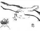
The shape of wind-eroded rocks largely depends on the structure and composition of the rock. With amazing precision, the wind selects the weakest rocks and forms grooves, grooves, niches, and pits. So, if a horizontally layered strata consists of alternating hard and soft rocks, then on its surface the hard rocks will form ledges, cornices, alternating with niches. (Fig. 1). In conglomerates with weak cement, hard pebbles form a lumpy surface of often bizarre shapes.
Whirling around lonely rocks, the wind helps create mushroom-shaped, columnar shapes. The ability of the wind to isolate and isolate the hardest and strongest sections of rocks in nature is called aeolian preparation. It is she who creates the most bizarre shapes, often reminiscent of silhouettes of animals, people, etc. (Fig. 2).
In massive rocks, the wind removes weathering products from cracks, widens the cracks and creates columnar shapes with steep vertical walls, arches, etc. In layers with a hidden-concentric texture (extrusive rocks, sometimes sandstones), the wind contributes to the creation of spherical shapes. The same forms are found in rocks containing spherical nodules, which are surprisingly well prepared.
Very interesting shapes are created in rocks covered with a desert tan crust. Under this hard crust there is usually a softened, destroyed layer. Corrasia, having punched a hole in the crust, blows out loose rocks, forming cells.
6.1.2. Aeolian transport.
The transport activity of the wind is of great importance. The wind lifts loose fine-clastic material from the Earth's surface and transports it over long distances across the globe, so this process can be called planetary. The wind mainly carries the smallest particles pelitic (clayey), silty (dusty) and psammitova (sand) dimension. The transfer distance depends on the size and shape of the debris, their specific gravity, and wind strength. Large fragments of rocks - blocks, boulders - during tornadoes move from their place and are pushed or rolled along the surface of the Earth within a few meters. Pebbles, debris, debris and gravel during storms and hurricanes can come off the ground, rise up, then fall and rise again, i.e. they move along the surface in spasmodic steps, over long distances in total. Sands constitute one of the most important components of aeolian transport. The bulk of sand grains are transported near the Earth's surface at a height of 3-4 meters. During flight, grains of sand often collide with each other, and therefore, in very strong winds, the humming and ringing of the moving mass is heard. Sand grains are ground, abraded, and weaker or cracked grains sometimes break apart. The most stable during long-distance transport are quartz sand grains, which constitute the main mass of the sand flow.
Silt and clay particles (volcanic ash, etc.) sometimes make up main part solid aeolian flow. They can saturate the entire troposphere and even go beyond its limits. The range of transfer of this material can be unlimited. Fine particles that rise to great heights are transported especially far.
ETC: Thus, red ash ejected from the Krakatoa volcano (Indonesia) in 1883 flew around globe three times and stayed in the air for about three years.
Let us give several examples of long-distance movement of fragmentary material. Dust raised by the wind in the deserts of Dashti-Margo and Dashti-Arbu in Afghanistan is transported to the Karakum region. Dust from the regions of Western China settles in Northern Afghanistan and the republics of Central Asia. Chernozem, blown by the wind in Eastern Ukraine on May 1, 1892, partially fell in the Kaunas area on May 2, precipitated with black rain in Germany on May 3, in the Baltic Sea on May 4, and then in Scandinavia.
ETC: The amount of sand and dust carried by the wind is sometimes very large. In 1863, dust from the Sahara fell on the Canary Islands in the Atlantic; its mass was determined to be 10 million tons. The total amount of aeolian material transferred from land to sea, according to A.P. Lisitsyn’s calculations, exceeds 1.6 billion tons per year.
6.1.3. Aeolian accumulation.
The composition of wind-borne particles is very diverse. Sand and dust storms are dominated by grains of quartz, feldspar, less often gypsum, salt, clayey silt and calcareous particles, soil particles, etc. Most of them are a product of the destruction of rocks exposed on the surface of the Earth. Some of the dust is of volcanic origin ( volcanic ash and sand ), part space ( meteorite dust ). Most of the dust carried by the wind falls on the surface of the seas and oceans and is mixed with the marine sediments formed there; a smaller part falls on land and forms aeolian deposits.
Among the aeolian deposits there are clayey, silty and sandy . Sandy aeolian deposits are most often formed in close proximity to areas of deflation and corrosion, i.e. at the foot of exposed mountains, as well as in the lower parts of river valleys, deltas and sea coasts. Here the wind blows and transports alluvium and sediments of sea beaches, forming specific hilly landforms. Clayey and silty aeolian deposits can be deposited at a considerable distance from the blowing area. Carbonate, as well as salt and gypsum aeolian deposits are much less common.
Modern aeolian deposits are predominantly loose rocks, since their cementation and compaction occur more slowly than that of aqueous sediments.
The color of aeolian deposits varies. Yellow, white and gray colors predominate, but deposits of other colors are also found.
ETC: So, in 1755, a layer of red dust 2 cm thick fell in southern Europe. When the deflation products of chernozem soils are transported, black dust falls out.
Aeolian deposits often show not parallel, but oblique or wavy bedding. Such deposits are called cross-bedded . By the direction of the cross-layers, one can determine the direction of the wind that formed them, since the cross-layers are always inclined in the direction of movement of the wind jets.
The rate of accumulation of aeolian sediments varies greatly.
ETC: One day, a layer of dust 1.76 m thick was discovered on the deck of a half-sunken ship. It formed over 63 years, i.e. on average, about 3 cm were deposited per year. There were cases when a layer several centimeters thick accumulated in 1 day.
Masses of debris carried by the wind are sorted during the flight. Larger sand particles fall out earlier than finer clay particles, and therefore separate accumulation of sand, loess, clay and other aeolian sediments occurs. Among aeolian deposits on land, the largest area is occupied by sand. Dust particles can often accumulate next to them, and when compacted, loess is formed.
Loess is a soft, porous rock of yellowish-brown, yellowish-gray color, consisting of more than 90% silty grains of quartz and other silicates, alumina; about 6% is calcium carbonate, which often forms concretions and irregularly shaped concretions in loess. The size of the loess grains corresponds to the silt and clay fractions and, to a lesser extent, to the sand fraction. In loess there are numerous pores in the form of hollow tubes formed due to the roots of plants that were here.
The largest amount of loess formed in the Quaternary period in the territory stretching from Ukraine to Southern China. V.A. Obruchev explained the origin of these rocks as follows: in the Quaternary period in the north of Eurasia there was a continuous cover of ice. In front of the glaciers there was a rocky desert, composed of rock fragments of various sizes brought here by glaciers. Constant cold winds blew from the glacier to the south. The wind, flying over the moraine, picked up small dusty-clay particles from it and carried them south. Heating up, the wind weakened, the particles fell to the ground and formed a loess layer in the above-mentioned strip. Typical loess has no layering, it is not very granular, and therefore, when washed away by flowing waters, it forms ravines with very steep vertical walls. The thickness of ancient loess strata in China reaches 100 meters. Loess and loess-like rocks are widespread in the republics of Central Asia and Transcaucasia, Ukraine and Afghanistan.
Aeolian deposits can be found in almost any part of the land, in any landscape zone. But large and powerful accumulations of aeolian material are formed in arid climate zones, favorable for the development of all types of aeolian process.
6.2. Weathering.
During the weathering process, two groups of weathering products arise: movable , which are carried away to a particular distance, and residual , which remain at the place of their formation. Residual, undisplaced weathering products represent one of the most important genetic types of continental formations and are called eluvium.
The totality of weathering products of eluvial formations of different compositions in the upper part of the lithosphere is called weathering bark . The formation of the weathering crust, the composition of its constituent formations and thickness vary depending on climatic conditions - a combination of temperature and humidity, the supply of organic matter, as well as relief. The most favorable for the formation of powerful weathering crusts is a relatively leveled topography and a combination of high temperature, high humidity and abundance organic matter.
Eluvium may consist of large fragments and small ones formed during further destruction, in which main role chemical agents play. Under the influence of water containing oxygen and carbon dioxide, all rocks eventually turn into sand, or sandy loam, or loam, or clay, depending on its composition, quartzite will turn into pure sand, white or yellowish, sandstone will give clay sand , granite - first gruss from individual grains, and then loam, clay shale - clay. Limestone, usually impure, loses lime, which is dissolved and carried away by water, leaving impurities in the form of clay, clean or sandy. These end products of weathering in the eluvium are mixed with more or less rubble and debris in various stages of alteration.
Associated with eluvium are deposits of bauxite, from which aluminum, kaolin, brown iron ore and other minerals are obtained. When bedrock breaks down, the persistent minerals it contains are released. They can form valuable mineral accumulations - placers. For example, eluvial diamond placers over kimberlite pipes, gold placers over gold-bearing veins.
The weathering product located on the slopes of mountains and valleys is called deluvium , which differs from eluvium in that its constituent parts are not at the site of initial formation, but have slid or rolled down under the influence of gravity. All slopes are covered with a more or less thick layer of colluvium. Diluvium, wetted by water, can shift and creep down the slope, usually very slowly, imperceptibly to the eye, sometimes quickly. Heavily saturated with water, it turns into thick mud, which crawls down, tears off and crumples the turf cover, pulls out bushes and even knocks down trees growing on the colluvium as it moves. Such mud flows, sometimes of considerable length and width, have been observed in many countries. At the bottom of the valley they stop, forming fields of thick mud with clods of turf, fallen trees and bushes.
At the foot of collapsing cliffs, debris that has fallen off accumulates, forming extensive screes on the slopes, often easily mobile and difficult to pass, consisting of large boulders or rubble creeping down underfoot. On the flat surface of mountain peaks, outcrops of hard rock disintegrate during weathering into separate parts, turning into a continuous scattering of blocks sticking out in different directions. These placers are especially frequent in Siberia and the Arctic, where they are formed by the combined action of severe frosts and moisture from fogs, rain and melting snow. But even in warm climates, mountain peaks that rise above the permanent snow line, where the climate is almost arctic, are destroyed quickly and produce abundant screes and placers.
Weathering is a combination of many factors: temperature fluctuations; chemical effects of various gases (0 2) and acids (carbon dioxide) dissolved in water; exposure to organic substances formed as a result of the vital activity of plants and animals and during the decomposition of their remains; propping action of roots of bushes and trees. Sometimes these factors act together, sometimes separately, but sudden changes in temperature and water regime are decisive. Depending on the predominance of certain factors, there are physical, chemical and biogenic weathering.
6.2.1. Physical weathering manifests itself in the mechanical destruction of bedrock under the influence solar energy, atmosphere and water. Rocks are subject to heating and cooling. When heated, they expand and increase in volume; when cooled, they contract and decrease in volume. This expansion and contraction is very slight; but, replacing each other not for a day or two, but for hundreds and thousands of years, they will eventually reveal their effect. Rocks are made up of different minerals, some of which expand more, others less. Due to different expansions, large stresses arise in these minerals, the repeated actions of which ultimately lead to a weakening of the bonds between minerals and the rock crumbles, turning into an accumulation of small fragments, rubble, and coarse sand. Multi-mineral rocks (granites, gneisses, etc.) are destroyed especially intensively. In addition, the coefficient of linear expansion, even for the same mineral, is not the same in different directions. This circumstance, with temperature fluctuations, causes stress and disruption of the adhesion of mineral grains in single-mineral rocks (limestone, sandstone), which leads over time to their destruction.
The rate of weathering is influenced by the size of the mineral grains composing it, as well as their color. Dark rocks heat up and therefore expand more than light rocks, which reflect the sun's rays more strongly. The color of individual grains in the rock has the same meaning. In a rock consisting of grains of different colors, the cohesion of the grains will weaken faster than in a rock consisting of grains of the same color. The least resistant to changes in cold and heat are rocks consisting of large grains of different colors.
The weakening of the adhesion between the grains leads to the fact that these grains are separated from each other, the rock loses its strength and crumbles into its constituent parts, turning from solid stone into loose sand or debris.
Temperature weathering occurs especially actively in areas with a hot continental climate - in desert areas, where daily temperature changes are very large and there is no or very poor development vegetation cover, and low precipitation. In addition, temperature weathering occurs very intensively on the slopes of high mountains, where the air is clearer and insolation is much stronger than on the neighboring lowlands.
The destructive effect on rocks in the desert is exerted by salt crystals that form during the evaporation of water in the thinnest cracks and increase the pressure on their walls. Capillary cracks expand under the influence of this pressure, and the solidity of the rock is broken.
Different rocks erode at different rates. The great Egyptian pyramids, built from blocks of yellowish sandstone, annually lose 0.2 mm of their outer layer, which leads to the accumulation of talus (talus with a volume of 50 m 3 /year is formed at the foot of the Khufu pyramid). The weathering rate of limestone is 2-3 cm per year, and granite is destroyed much more slowly.
Sometimes weathering leads to a kind of scaly peeling called desquamation breeds This is the peeling of thin plates from the surface of exposed rocks. As a result, irregularly shaped blocks turn into almost regular balls, reminiscent of stone cannonballs (for example, in Eastern Siberia, in the valley of the Lower Tunguska River).
When it rains, the cliffs get wet: some rocks are porous, highly fractured - more, others - dense - less; then they dry out again. Alternate drying and wetting also affects the weakening of particle adhesion.
Water freezes in cracks and small voids (pores) of rocks and has an even stronger effect. This happens in the fall, if frost strikes after rain, or in the spring, after a warm day, when snow melts in the heat and water penetrates deep into the cliffs and freezes at night. A significant increase in the volume of freezing water causes enormous pressure on the walls of the cracks, and the rock splits. This is especially typical for high polar and subpolar latitudes, as well as in mountainous regions, mainly above the snow line. Here, the destruction of rocks occurs mainly under the influence of the mechanical action of periodically freezing water located in the pores and cracks of rocks ( frost weathering ). In high-mountain areas, rocky peaks are usually broken by numerous cracks, and their bases are hidden by a trail of scree, which were formed due to weathering.
Thanks to selective weathering, various “natural wonders” appear in the form of arches, gates, etc., especially in sandstone layers.
ETC: For many regions of the Caucasus and other mountains, the so-called “idols” are very characteristic - pyramidal pillars topped with large stones, even whole blocks measuring 5 - 10 m or more. These blocks protect the underlying sediments (forming a pillar) from weathering and erosion and look like the caps of giant mushrooms. On the northern slope of Elbrus, near the famous Djilysu springs, there is a ravine called the “Ravine of Castles” - Kala - Kulak, the “castles” are represented by huge pillars made of relatively loose volcanic tuffs. These pillars are topped by large blocks of lava that formerly formed a moraine, a glacial deposit that is 50 thousand years old. The moraine subsequently collapsed, and some of the blocks played the role of a “mushroom cap” that protected the “leg” from erosion. There are similar pyramids in the valleys of the Chegem, Terek and other places in the North Caucasus.
6.2.2. Chemical weathering. Simultaneously and interconnected with physical weathering, under appropriate conditions, the process of chemical weathering occurs, causing significant changes in the primary composition of minerals and rocks and the formation of new minerals. The main factors of chemical weathering are: water, free oxygen, carbon dioxide and organic acids. Particularly favorable conditions for such weathering are created in a humid tropical climate, in places with abundant vegetation. There is a combination of high humidity, high temperature and a huge annual decline in the organic mass of plant residues, as a result of the decomposition of which the concentration of carbon dioxide and organic acids significantly increases. The processes occurring during chemical weathering can be reduced to the following main ones: chemical reactions: oxidation, hydration, dissolution and hydrolysis.
Oxidation well developed, for example, in the iron ores of the Kursk magnetic anomaly, where the mineral magnetite (FeFe 2 O 4) turns into a chemically more stable form- hematite (Fe 2 O 3), which forms rich ore “iron hats”, i.e. accumulations of good ore. Many sedimentary rocks, such as sands, sandstones, clays, containing inclusions of ferruginous minerals, are colored brown or ocher, indicating the oxidation of these metals.
Hydration associated with the addition of water to the mineral. Thus, anhydrite (CaSo 4) turns into gypsum (CaSo 4. 2H 2 O), containing two molecules of water. Hydration causes an increase in the volume of the rock, deformation of it and the covering sediments.
During hydrolysis, i.e. decomposition of a complex substance under the influence of water, feldspars ultimately turn into minerals of the kaolinite group - white plastic clays (the best porcelain is made from them) containing aluminum, silicon and water molecules. Mount Kaolin in China is composed of just such clays.
At dissolution Some chemical components are removed from the rock. Rocks such as rock salt, gypsum, and anhydrite dissolve very well in water. Limestones, dolomites and marbles dissolve somewhat less well. Water always contains carbon dioxide, which, when interacting with calcite, decomposes it into calcium and bicarbonate ions (HCo 3 -). Therefore, limestones always look like they have been etched, i.e. selective dissolution. Grooves, tubercles, and notches are formed on them. If limestone in some places “experiences silicification” (replacement with silica) and becomes stronger, then these areas will always protrude during weathering, forming, for example, landforms such as hills.
6.2.3. Biogenic weathering associated with the active influence of plant and animal organisms on rocks. Even the smoothest rock is inhabited by lichens. The wind carries their tiny spores into the thinnest cracks or sticks to a surface wet from rain, and they sprout, tightly attaching to the stone, sucking from it, along with moisture, the salts they need for life, and gradually corrode the surface of the stone and widen the cracks. The corroded stone sticks more easily, and small grains of sand and dust, which are brought by the wind or washed away by water from the overlying slope, are more likely to get into the widened cracks. These grains of sand and dust little by little form the soil for higher plants (herbs, flowers). Their seeds are carried by the wind, fall into cracks and into the dust that has accumulated between the thalli of lichens and sticks to the rock corroded by it, and germinate. The roots of the plants go deeper into the cracks, pushing pieces of rock to the sides. The cracks expand, even more dust and humus from outdated grasses and their roots are packed into them - and now a place is prepared for large bushes and trees, the seeds of which are also carried by wind, water or insects. Bushes and trees have perennial and thick roots; penetrating into cracks and thickening over the years, as they grow, they act like wedges, expanding the crack more and more.
A variety of animals contribute to the destruction of rocks. Rodents dig a huge number of holes, cattle trample down vegetation; even worms and ants destroy the surface layer of soil.
Carbon dioxide and humic acids released during the decomposition of organic residues enter the water, which, as a result, sharply increases its destructive ability. Vegetation cover promotes the accumulation of moisture and organic matter in the soil, thereby increasing the time of exposure to chemical weathering. Under the cover of soil, weathering occurs more intensely, because The rock is also dissolved by organic acids contained in the soil. Bacteria, which are ubiquitous, produce substances such as nitric acid, carbon dioxide, ammonia and others, which contribute to the rapid dissolution of minerals contained in rocks.
Thus, the processes of physical, chemical, and biogenic weathering occur constantly and everywhere. Under their influence, even the strongest rocks are slowly but inevitably destroyed, gradually turning into gruss, sand and clay, which are transported by water streams over vast distances and, ultimately, are deposited again in lakes, oceans and seas.
7. The place of this topic in the curricula and topics of the State Geological Fund of NSU and OIGGM SB RAS.
8. Conclusion.
In conclusion, I would like to summarize everything that was stated above. For many centuries, people have been observing various natural processes, noticing their features, causes and consequences; pay attention to the fact that some processes occur more often and with greater force, while in others they can be observed very rarely. It is difficult not to notice that natural processes are interconnected, they change our planet constantly and continuously, and it is impossible to study anything without paying attention to others Natural resources and phenomena. It is impossible to clearly determine whether these processes have a beneficial effect on the environment around us or not. And whether it’s rain in the driest summer or a flood, a cool breeze on a hot afternoon or a strong hurricane sweeping away everything in its path, we cannot do without these processes, because... any natural phenomenon is necessary.
Scientists all over the world study the laws of nature, its processes, phenomena, and the connection between them, in order to prevent disasters that bring destruction and death, and to promote more favorable processes for humanity. By learning the laws by which nature lives, a person learns to communicate with it.
Aeolian processes have very diverse consequences, but they all bring necessary changes in the life of our planet, and we, studying these complex but amazing processes, can only admire enormous power nature!!!
9. References:
- Obruchev V.A. Entertaining geology M.: publishing house of the Academy of Sciences
- Encyclopedia for children: GEOLOGY. M.: Avanta+, 1995
- Zhukov M.M., Slavin V.I., Dunaeva N.N. Fundamentals of Geology.-M.: Gosgeoltekhizdat, 1961.
4. Gorshkov G.N. Yakusheva A.F. General geology - Moscow State University Publishing House, 1958
5. Ivanova M.F. General geology-Publishing house “ graduate School"Moscow, 1969
Exogenous processes - occur on the surface of the earth under the influence of the radiant energy of the sun and are transformed into the energy of movement of water, lithosphere substances, these include the activity of rivers, lakes, wind, glaciers, seas, etc.
These processes of change proceed in the overwhelming majority extremely slowly from a person’s point of view, imperceptible not only directly to his eye, but often imperceptible to many successive generations of people
Fluvial- a set of geomorphological flows carried out by permanent and temporary water flows. In Geological work of water: Destruction of hydraulic reservoirs, Movement of products of washout and erosion, deposition of transported products (accumulation)
Water erosion is the process of washing away rocks and soils, tearing off and carrying away particles.
Flat washout (horizontal erosion) - the removal of soil particles by rain and melt water along a relatively flat slope. Diluvium - well-sorted weathering products redeposited by the atmosphere. precipitation along the slopes of the watershed. (Meaning: flattening the slope from weathering products)
Deep erosion - flat erosion occurs only on smooth slopes, if there are irregularities - the streams move in the direction of the slope and erode the surface in depth, forming water-erosive FR (Erosion furrow - the original form of temporary watercourses, is small in size; ravines - an open negative form with steep slopes , deepened to 50m, length 3-5km, width up to 150-300m
The basis of erosion is the horizon surface. From which erosion began and below which destruction cannot occur
Gullies (coastal, bottom, inclined). The growth of ravines depends on climate, topography, human activity, etc.
Landslides and mud flows - processes occur on large slopes and are most pronounced in the mountains; usually there is no water in them
Glacial– ice activity, image of glaciers. (mountain and cover or continental glaciers). When a glacier moves (movement speed up to tens of M per day, depends on the slope): destruction of rocks, transportation of material, accumulation of material
Exaration – glacial gouging, exogenous. The process of destruction of glacial GPs.
Exaration F:
Plowing basins - image. With the pressure of glaciers and the plowing out of uneven bases of depressions. Lamb foreheads. In the mountains there are pits (cruciform shapes on mountain slopes), troughs, cirques (depressions in the rocks where pits merge).
In the zone of glacier accumulation the image is: hills of the main moraine, druslins, moraine ridges.
Fluvioglacial– when glaciers melt, the image of water flows. (Shapes: Eskers - narrow, long, straight or winding ridges parallel to the movement of the glacier, similar to railway embankments (length - 10 km, width - 150 m, height - 100 m). Kama - hills, 30 m high or more, composed of layered fluvioglacial deposits cm (round, cone-shaped)). Outwash fields are gentle, flat, large-radius glacial flow cones; they represent vast plains. Loess fields are dome-shaped rocks, consisting of particles 0.01-0.05 mm in size, they are porous
Cryogenic– rocks with negative temperatures in the presence of ice in cracks. Types: seasonal permafrost, permafrost.
Cryolithozones - where permafrost is developed.
Types of permafrost: Island (permafrost up to 25 m), not continuous (up to 100 m), continuous (yes 1000 m)
Relief caused by permafrost: 1. frost cracking of the soil (alternate freezing and thawing of the soil - slightly convex shape, surrounded by vegetation, dimensions up to 100 m or more)
2. Thermokarst- thawing and subsidence of the soil leads to the formation of depressions and basins (alsy (basins, up to several kilometers in diameter, up to 30 m deep)) 3. Soil swelling - an increase in the volume of water during freezing. (baijarahi - heaving mounds, an image of a combination of frost expansion and soil erosion by water and an image of a crack (up to several meters in height))
Suffusively-karst- groundwater activity.
Aeolian- Aeolian processes are associated with geological and geomorphological wind activity.
Corrosion - grinding, polishing of rocks with a wind flow containing rock particles.
Corazion niches, stone mushrooms, pillars - the most corrosive work is carried out by the wind flow in a layer of 1.5-2 m from the surface of the earth
Deflation is the blowing, dispersal, capture and transport of rock particles. During deflation, loose rock material is blown out and dispersed.
Biogeomorphological The processes of changing the Earth's surface as a result of the activity of living organisms are called biogeomorphological, and the relief created with the participation of plants and animals is called biogenic. These are mainly nano-, micro- and mesoforms of relief.
A grandiose process, carried out largely thanks to organisms, is sedimentation (for example, limestones, caustobiolites and other rocks).
Plants and animals also participate in a complex universal process - weathering of rocks, both as a result of direct impact on rocks and through the products of their vital activity. It is not for nothing that biological weathering is sometimes distinguished along with physical and chemical weathering.
Novosibirsk State University
Faculty of Geology and Geophysics
Department of General and Regional Geology
Vert Irina Vladimirovna
Course 1, group 054
COURSE WORK
Abstract topic:
EOLIAN PROCESSES
Scientific adviser:
LABEKINA IRINA ALEKSEEVNA
Reviewer (BREDIKHINA
OKSANA NIKOLAEVNA)
Novosibirsk
ANNOTATION
This course work contains materials on the topic “Aeolian processes”; the reasons for the process in question and its consequences are also outlined below. The work is written on the basis of a complex multi-level plan containing nine main points (including introduction, notes, conclusion and list of references) and twelve minor ones, including the goals and objectives of the research, as well as information about the objects and subjects of research. It consists of 21 pages, on which there are 2 figures (page 8 and page 12, respectively), 175 paragraphs and 945 lines, and there are also a large number of examples in the work. At the end of the course work (on page 21) there is a list of all the literature used.
In the given course work the materials on a theme “Geological work of a wind” are assembled, also reasons of considered process and its consequences are stated below. The work is written on the basis of the complex multilevel plan containing nine basic items (including introduction, notes, conclusion and list of the used literature) and twelve minor, including purpose and research problem, and also item of information on objects and subjects of researches. It consists of 21 pages, on which 2 figures (page 8 and page 12 accordingly), 175 paragraphs and 945 lines are placed, and even in work there is a plenty of examples. At the end of course work (on page 21) there is a list of the used literature.
Before a perusal course I recommend to address to a TABLE of CONTENS, and then to the NOTE.
1. Notes (symbols)……………………………...4p.
2. Introduction…………………………………………….………………….4pp.
3. Formulation of the topic……………………………..………...………5pp.
4. Goals and objectives of the research……………………..…………………..6p.
5. Objects and subject of research……………..………...………….7pp.
5.1. Wind, types of winds…………………………..…………...……….…7pp.
5.2. Classification of deserts…………………………….….…………..8p.
5.2.1. Deflationary deserts………………………...…….….….……8pp.
5.2.2. Accumulative deserts……………………………………. 8 pages
6. Current knowledge in this area………….………………..10pp.
6.1. Geological work of wind……………………...………….……10pp.
6.1.1. Deflation and corruption………………………………….…..….11p.
6.1.2. Aeolian transportation…………………..…………………..12p.
6.1.3. Aeolian accumulation…………………….…..………………………p.
6.2. Weathering…………………………………….…..…………….14p.
6.2.1. Physical weathering……………………..……….………p.
6.2.2. Chemical weathering…………………..…....………….…17p.
6.2.3. Biogenic weathering………………………..………………p.
7. The place of this topic in the curricula and topics of the State Geological Physics of NSU and OIGGM SB RAS………………………………………………….…….19p.
8. Conclusion……………………………………………………………...20p.
9. List of references…………………………………………………………….20 pages.
1. Note.
The text contains abbreviations and symbols:
· Page (page)
· Rice. (drawing)
· ETC: ( the paragraph following this designation contains an example )
· All basic concepts and definitions are highlighted special font
Each point of the plan is highlighted in large print, has a number corresponding to the number in the table of contents and is located on the page indicated in the table of contents.
2. Introduction.
Before writing about what is contained in my course work, I would like to tell you why I chose this particular topic. Looking through the proposed topics for the course work for the first time, I immediately drew attention to topic number 51. What attracted me to this topic was that all our lives we have been faced with the work of the wind, with aeolian processes, but few of us have ever thought about what are the causes of the wind, what is its activity and what significance does it have in our lives...
Wind has always been given great importance; the wind has always been a symbol of change and innovation. Even in folk sayings and phraseological units, the wind was given an important place: Throwing words to the wind, the wind in the head, a windy person, and so you can continue for a very long time... So I wanted to know more about what always accompanies us...
And in general, I believe that the topic for the coursework should be chosen so that it is, first of all, of interest to the person writing the coursework. And secondly, it would be interesting and useful to those who will listen to it. I think that what I wrote about in my work is not only interesting, but also useful.
3. Formulation of the topic and problem.
The geological activity of wind is associated with the dynamic effect of air jets on rocks. It is expressed in the destruction, crushing of rocks, smoothing and polishing their surface, transfer of small fragmentary material from one place to another, in its deposition on the surface of the Earth (continents and oceans) in an even layer, and then unloading this material in the form of hills and ridges on certain land areas. The geological work of wind is often called aeolian (named after the god of the winds, Aeolus, from ancient Greek myths).
ETC:
Aeolian processes also include weathering. It is a process of change (destruction) of rocks and minerals due to their adaptation to the conditions of the earth's surface and consists of a change in the physical properties of minerals and rocks, mainly reduced to their mechanical destruction, loosening and change in chemical properties under the influence of water, oxygen and carbon dioxide atmospheric gas and vital activity of organisms.
Obruchev V.A. wrote the following about weathering: “So, little by little, from day to day, from year to year, from century to century, imperceptible forces work on the destruction of rocks, on their weathering. We don’t notice how they work, but their fruits labors are visible everywhere: solid solid rock, which was initially cut only by thin cracks, turns out, thanks to weathering, to be more or less severely destroyed; the first cracks have expanded, new ones have appeared in even greater numbers; small and large pieces have fallen off from all the corners and edges and lie immediately in heaps at the foot of the cliff or rolled down the slope, forming screes. The smooth surface of the rock became rough, corroded; in some places lichens are visible on it, in places there are potholes and cracks, in places there are black or rusty smudges."
The geological work of wind is significant and covers large areas, because deserts on Earth alone occupy 15-20 million km. Within the continents, the wind acts directly on the surface of the earth's crust, destroying and moving rocks, forming aeolian deposits. In areas of seas and oceans this impact is indirect. The wind here forms waves, permanent or temporary currents, which in turn destroy rocks on the shores and move sediment at the bottom. We should not forget the significant importance of wind as a supplier of clastic material that forms a certain type of sedimentary rock on the bottom of seas and oceans.
The complex movements of air masses and their interactions are further complicated by the formation of giant air vortices, cyclones and anticyclones. Moving over the seas, cyclones cause huge waves and tear off spray from the water, resulting in a rotating column of water in the center. Cyclones have great destructive power. As a result of their activities, surges of water into river mouths are dangerous, especially in areas of high tides. The coincidence of surges and tides causes the water to rise to 15-20 meters or more. In the tropical zone, during cyclones, quite heavy objects were thrown in the air over a considerable distance.
ETC: One of the destructive hurricanes was Inez, which raged in September-October 1966 in the Caribbean Sea. Its speed in the center was about 70 m/sec, and the pressure dropped to 695 mm.
4. Goals and objectives of research.
The wind carries out geological work in various parts of the Earth's surface, but since the force of the wind on the tops of mountains is much greater than in basins and lowlands, its activity is more noticeable there. The importance of wind activity is especially great in areas of dry climate, sharp daily and annual temperature fluctuations.
Aeolian activity, as a rule, brings harm to humans, since as a result of it, fertile lands are destroyed, buildings, transport communications, tracts of green space, etc. are destroyed.
ETC: A significant part of the modern Libyan Desert (North Africa) was a fertile region 5-7 thousand years ago. The sands turned this area into a desert. In Central Asia, on the banks of the Amu Darya, the city of Tartkul was located. Due to the intense erosion of coastal streets by river water, people left the city, and then for several years the city was covered with desert sand. Deflation in Ukraine has destroyed vast areas of crops. In buildings on the outskirts of deserts, due to corrosion, glass quickly becomes cloudy, houses become covered with scratches, and grooves appear on stone monuments; for example, the famous sphinx near Cairo in Egypt is covered with furrows.