Culture and traditions of the peoples of Libya. Geography of Libya: relief, climate, population, flora and fauna. Internal differences and cities
Today it is one of the fairly successful African countries. It is located in the north of the mainland. The area of the state is almost 1,760 thousand km 2. The capital is the city of Tripoli.
In the north, Libya has access to the Mediterranean Sea, making it the largest African country in the Mediterranean basin. It neighbors Egypt, Algeria, Tunisia, Chad and Niger.
Story
The country of Libya is a state whose history begins in ancient times. According to archaeological excavations, scientists have found that the sites of ancient people in this area date back to the Neolithic era. In the ancient period of history, Libya passed from hand to hand and belonged at different times to Carthage, Phenicia, Ancient Greece and Rome, and Byzantium. In the 7th century it became part of the Arab Caliphate.
In the Middle Ages, in the 16th century it was captured by the Ottoman Empire. Since this period, Islam has spread throughout the country. Remained part of the empire until its collapse in 1911. Afterwards it became
A turning point in the state
The country gained its independence in 1951, becoming the United Kingdom. However, the king was overthrown in 1969 and the socialists, led by Muammar Gadafi, came to power, forming the Libyan Arab Republic. Later the state was renamed Jamahiriya (popular masses). This is the name given to the territory of present-day Libya. In 2011, during political unrest and civil war, the population, with the help of dissidents and revolutionaries, overthrew the previous government led by Gaddafi. Since then, military clashes have constantly occurred here, which cannot be calmed down and now the country is in a state of civil war.

State name
The name of the country comes from the ancient dialect of the Berber tribes who lived in these territories. The first political association of people was called “Libu”, and later the state formed on these lands also became known as such. According to the rules for translating Arabic dialects into Russian, it would be correct to call the country “Libia”, but the previously established “Libya” remained normatively fixed.
Geographical characteristics
Libya today is 90% desert, although in earlier times there was much more vegetation. In the west, the relief rises slightly, forming the Idekhan-Marzuk and Aubari plateaus. Here is the highest point of the country - Bikku Bitti (2,267m). Closer to the coast, the desert recedes, leaving a small area of arable land. This area occupies only 1% of the entire territory, but provides food for Libya's needs. The coastline is indented, its length is 1,770 km. The largest bay is Sidra.

Climate
The climate of Libya, where the population suffers from unexpected changes in weather conditions, differs in the desert regions and on the coast. The desert has a dry, tropical climate, with characteristic sharp temperature fluctuations day and night. Average January temperatures in the desert are + 15°С…+18°С, in July +40°С…+45°С. Often this mark rises to +50°C. It is in the desert, not far from the capital, that the planet’s temperature maximum is +57.8°C. In the northern part of the state the climate is slightly milder - subtropical, Mediterranean type. The annual precipitation here is 200-250 mm. In the desert part, this figure decreases to 50-100 mm/year. In addition, dust storms (khamsin, ghibli) constantly blow in this territory. Most of the territory is unsuitable for agriculture. Due to climatic conditions, the country's flora and fauna are very poor. Due to which the already small population of Libya suffers greatly - there is constant hunger.
Population of Libya
Despite the large territory of the state, only about 6 million people live in Libya. Most of the local residents gathered in the northern regions of the state, since living conditions here are milder in terms of climate. 88% of people live in the major cities of Benghazi. Libya is 50 people per 1 km 2. It is worth noting that this figure is quite small.
A characteristic feature of the population is that a third of the people living in Libya are children under 15 years of age. This inequality is caused by the fact that more than 50 thousand people died during the civil war in recent years. adult population. Also, more than 1 million people emigrated from the country.

Nations
In terms of national composition, the population of Libya is homogeneous. Most of them are Arabs. Also in the cities there are Circassians, Tuaregs, and Berbers. They inhabit most of the territory of Libya. The population on the Mediterranean coast consists of a few communities of Greeks, Maltese, and Italians. They are mainly engaged in fishing. The official language of the state is Arabic. Sometimes Italian and English are found.
97% of the population professes Sunni Islam. Christianity accounts for just under 3%. Representatives of other religions also meet alone.
Administrative division and economic characteristics
Since 2007, a new system of administrative division has been introduced in Libya. The state is divided into 22 municipalities.
For a long time, the fate of Libya (the population has been suffering for several centuries) was not very successful. She was one of the planet, but by the 60s of the last century the situation had changed. It was during this period that the largest oil deposits were discovered on the territory of the state. Due to the fact that everyone was thrown into the development of the oil industry, the level of development of other industries dropped, and later they stopped developing altogether.
In addition to oil production, only agriculture is more or less developed in Libya, which only meets the needs of the local population.

The cultural level of development of the country is average. More than 90% of living people under the age of 16 can read and write. However, the population of Libya is gradually declining, because living here and getting higher education, including technical education, is quite difficult due to constant armed conflicts. All the country's funding goes to military support.
The official name is the Socialist People's Libyan Arab Jamahiriya (Al-Jamahiriyya al-Arabiya al-Libiyya al-Shaabiyya al-Ishtirakiya al-Uzma).
Located in North Africa. Area 1,760 thousand km2, population - 5.37 million people. (2002). The official language is Arabic. The capital is Tripoli (2.27 million people, 2001). Public holidays - Revolution Day on September 1 (since 1969), Proclamation Day of the Jamahiriya on March 2 (since 1977). The monetary unit is the Libyan dinar (equal to 1000 dirhams).
Member of the UN (since 1955), Arab League (since 1953), AU (since 1963).
Sights of Libya
Geography of Libya
It is located between 19° and 33° north latitude and 9° and 26° east longitude. It is washed in the north by the Mediterranean Sea. The coastline is poorly dissected, the only large bay is Greater Sirte (or Sidra, Arabic: Surt).
It borders Egypt and Sudan in the east and southeast, Chad and Niger in the south, Algeria and Tunisia in the west.
More than 9/10 of the territory is occupied by desert and semi-desert spaces of the Sahara (in the east called the Libyan Desert). Plateaus and plains (200-600 m) alternate with basins (up to 131 m below sea level), low (up to 1200 m) mountain ranges and ridges with extinct volcanoes. Only the northern spurs of the Tibesti Highlands rise higher in the southeast and extreme south, where the highest point of Libyan territory is located - Bette Peak (2286 m).
Among the mineral resources, proven reserves of oil stand out - 4130 million tons and natural gas - 1314 billion m3 (at the beginning of 2001, the first and third largest in Africa, respectively). Other resources have been poorly explored. There are known iron ore reserves of approx. 5.7 billion tons of magnesium (total reserves 7.5 million tons) and potassium (1.6 million tons) salts, the presence of phosphates, gypsum and raw materials for cement production, as well as other minerals.
Soil cover is almost absent in most of the territory, which is occupied by lifeless spaces, mainly sandy, clayey, pebble-crushed stone or rocky and salt marshes. The exceptions are a narrow (8-15 km wide) strip on the coastal plains of the north, except for its middle part along the Gulf of Sirte, as well as oases in the inland areas, usually low-lying, covered with fertile silty sediments. Only in the extreme east in Cyrenaica and in the west in Tripolitania does this fertile zone in some places expand to 40 km.
A desert tropical climate with sharp seasonal and daily temperature changes predominates. In summer, daytime temperatures usually exceed +40 °C, maximum temperatures exceed +50 °C; in winter during the day +25-30 °C, and at night 0 °C and below. On Tibesti, night frosts reach -15 °C. Central Libya is one of the regions of the planet with minimal rainfall. Typically, every 5-6 years the country is hit by droughts lasting 1-2 years. Only along the eastern and western coasts there are zones of a milder climate of the dry Mediterranean subtropics, 15-20 km wide, and then another 20 km inland - steppes.
There are no rivers with constant flow and natural freshwater lakes. There are numerous oueds (wadis) - dry riverbeds, sometimes filled with rain streams from October to March. There are large reserves of groundwater, feeding springs and fertile oases.
In humid places near the coasts, small zones of wild forests, thickets of Phoenician juniper, maquis (dense evergreen shrubs and low trees - myrtle, oleander, pistachio), groves of Aleppo pine, acacia, sycamore (fig tree, or fig), tamarisk, olive, carob have been preserved wood, cedar, cypress, holm oak, Euphrates poplar. Around the cities, plantings of eucalyptus, palm, pine, fruit trees and shrubs are expanding: pomegranate, apricot, citrus, olive, banana, almond, grape, laurel. It is mostly cultivable agricultural land, together with land in the interior oases, barely reaching 1.9% of Libyan territory.
The fauna is not very diverse. Reptiles (snakes, lizards), insects and arachnids (scorpions, phalanges) predominate; among mammals - rodents, hares are less common, among predators - jackals, hyenas, red foxes, fennec foxes (small representatives of wolves, weighing up to 1.5 kg); wild boars are more common in the north, artiodactyls - antelopes, gazelles - in the far south. Birds (pigeons, swallows, crows, eagles, falcons, vultures) nest more in oases, mountainous areas and coastal areas. Many migratory birds from European countries winter there. Coastal waters are rich - more than 300 species of fish, including commercial ones (anchovy, mackerel, tuna, horse mackerel, sardine, eel), as well as valuable species of sponges.
Population of Libya
Average annual natural population growth, according to UN statistics, was 4.2% in 1970-90, 2.1% in 1991-2000. Fertility rate 27.6%, mortality 3.5%, infant mortality 27.9 people. per 1000 newborns, average life expectancy is 75.9 years (2002). Age structure of the population: 0-14 years - 35%, 15-64 years - 61%, 65 years and older - 4%. The average male to female ratio is 1.06. Urban population 88% (2000). Literacy (% of residents over 15 years of age who can read) 76.2 (1995).
Libyan Arabs predominate everywhere (more than 80% of the number of citizens) - descendants of nomadic migrants (mainly 11th century) from the central part of the Arabian Peninsula. The indigenous inhabitants of the country are the Berbers, from one of the ancient tribes from which its name came, and the Tuaregs barely make up 6-7% of the population, mainly in the south and southwest, where small representatives of the Negroid race - the Tubu and Hausa - also live. There are many temporary residents in Libya (up to 663 thousand, 2002 estimate) - mostly working immigrants from Egypt, Sudan, Tunisia, Turkey, and other countries. The number and national composition of newcomers changed noticeably depending on the political and economic situation in the 1990s.
The only official language is Arabic, which is the mother tongue of the vast majority of native Libyans. A minority, mainly Berbers, are bilingual, although their writing also uses the Arabic alphabet. English and Italian are spoken in the cities.
The state religion is Islam. He is confessed by St. 99% of the population. A few Christians, mostly Catholics (almost exclusively visitors from Western Europe and very rarely local Berbers and Arabs). More than 2/3 of Muslims are Sunnis, followers of the Maliki madhhab - one of the four “orthodox” religious and legal schools. Up to 1/3 of Libyans are committed to the teachings of the Senusites.
History of Libya
The first mentions of early state formations (alliances of Berber tribes) on modern Libyan territory in Egyptian sources go back to the 2nd half. 3rd millennium BC From the 7th century BC. in the north of the country the “colonial powers” of antiquity competed: Greece, Carthage, Rome. To the south was the original kingdom of the Garamantes - a people probably formed by Berbers and descendants of people from the countries of the Aegean Sea. Garamantida, independent or dependent on Rome, existed for over one and a half millennia before the Arab conquest in 642-43. After the collapse of the Roman Empire, Libya experienced invasions, confrontation between feudal monarchies, religious and political associations of Arab and Berber tribes. From ser. 16th century Until 1911-12, the Ottoman Empire established itself here, whose power was limited to the coast and a few cities with immediate surroundings in the interior of the territory. To the beginning 1930s after long resistance the country was occupied by Italy; At the end of the 2nd World War, it came under the control of the British and French military administrations until 1951, when it became an independent kingdom. After the revolutionary putsch on September 1, 1969, young officers led by the unchallenged leader Muammar al-Gaddafi overthrew the monarchy and proclaimed Libya a republic, and since March 1977 it became “jamahiriyya” (from Arabic “mass”), or “state of the masses.”
Government structure and political system of Libya
The role of the fundamental law is officially fulfilled by the Koran, according to the brief Declaration on the Establishment of People's Power, adopted on March 2, 1977 at an extraordinary session of the highest legislative body - the General People's Congress (GPC). This document proclaimed “direct democracy” - democracy exercised through basic people's congresses, people's committees, corporate and professional associations, as well as through the All-Russian People's Commissariat. The Koran is declared to be the fundamental law - in fact the equivalent of the missing "secular" constitution.
The principles of the unique system of Libya were formulated by M. Gaddafi in the middle. 1970s as a “third world theory” that denies capitalism and communism. The government and other state bodies, along with party and all other political institutions in the generally accepted sense, have been abolished since 1977 and formally replaced by a system of “direct democracy”. The Constitutional Declaration declared its basis to be local (primary) people's assemblies of citizens. All adult population (from 18 years of age) of independent administrative-territorial units (neighborhoods, villages) are required to participate in such meetings to directly resolve current economic, cultural, and other issues of a local scale; to discuss national problems of domestic and foreign policy, make proposals and recommendations, as well as to elect permanent representative and executive bodies - people's committees and their secretaries. Primary committees automatically form meetings and elected bodies of the next, municipal level. Finally, municipal committees in full and primary secretaries, together with representatives of trade unions and other mass public organizations, form the supreme legislative body - the All-Russian People's Commissariat. More than half of its delegates are members of the secretariats of primary and municipal congresses, formed mainly on a territorial basis. The remaining members of the All-Russian People's Congress are delegated according to professional and corporate characteristics and are represented by members of the secretariats of people's congresses of corporate associations. At all industrial, construction and service enterprises, primary people's congresses (PNC) are created consisting of all their employees who have reached 18 years of age. These NCPs elect people's committees from among the leadership, technical personnel and workers, which perform the functions of state administration. The secretariats of NPCs of the same profile form people's congresses of the relevant industries, where they represent the teams of their enterprises.
The GNK elects a general secretariat, which performs the functions of the highest government body in the period between sessions. The Secretary General of the GNC - Mubarak Abdullah al-Shameh (since March 2000) - is formally the head of state and legislative branch. At sessions, usually annual, the GPC makes resolutions on national issues and appoints a Supreme People's Committee (essentially a government) consisting of the committee's general secretary (chief of cabinet) - Shukri Muhammad Ghanim (since June 2003) - and secretaries - heads of the relevant secretariats (ministries) .
The “Leader of the Libyan Revolution” - Muammar Abu Minyar al-Gaddafi - is formally only an honorary “ideological” leader of the country. However, without holding any official positions in the Jamahiriya system, he actually concentrates all the real power.
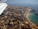
The capital and seat of all foreign diplomatic missions remains the center of the most densely populated region - the city of Tripoli (over 1269.7 thousand inhabitants, 2003 estimate), although almost all government secretariats (ministries) have been moved outside its boundaries since 1988: the majority are in the city. Surt, as well as in the cities. Benghazi (second in number of inhabitants - 734.9 thousand), Kufra, Ras al-Anouf.
From the 2nd half. 1980s economic and political liberalization campaigns are periodically carried out in Libya, many political prisoners have been released, and Libyan citizens are allowed free entry and exit from the country.
American sanctions against Libya, many of which had been in place since 1981, remained in effect in 2003, despite widespread dissatisfaction with them among business circles. On the contrary, the EU lifted most of the sanctions in September 1999 and invited Libya to participate in the Euro-Mediterranean Partnership program adopted in Barcelona in 1995. Some European countries began to actively develop political and economic ties with Libya in the hope of making profitable investments there. However, the European embargo on arms sales to Libya remained in force.
Armed forces (August 1999, thousand people): total - 65, incl. army - 35 (estimate), navy - 8, air force - 22. People's militia - 40 thousand. Military appropriations for the 1999/2000 fiscal year are $1.3 billion, or 3.9% of GDP.
Libya has diplomatic relations with the Russian Federation (established with the USSR on September 4, 1955). At the end of December 1991, it officially declared recognition of Russia.
Economy of Libya
GDP at currency purchasing power parity is $40 billion, and per capita is $7,600 (2001). Industry structure (est. 1997,%) by contribution to GDP (in brackets - by employment): agriculture, forestry and fishing - 7 (17), industry and construction - 47 (29), service sector - 46 (54).
The economically active population is 1.5 million people, unemployment is 30%, although the most significant contribution to the latter figure is made not so much by native Libyans as by immigrant workers (2000). Inflation in 2001 13.6%, in 2002 1.9% (estimate).
The oil and gas industry firmly holds a dominant role in the Libyan economy (about 68 million tons of oil were produced in 2001). Its contribution to gross industrial output (together with capital construction) exceeds 57%, while to current foreign exchange earnings - 98%, and to state budget revenues - 75%.
It was thanks to the abrupt growth of these incomes that the Libyan state in the 1970-80s. generously financed extensive development plans. Their main successes boiled down to the expansion and modernization of economic and social infrastructure, oil refining complexes (the annual capacity of installations for direct distillation is up to 17.4 million tons) and gas, mainly export-oriented, the creation of centers for the production of basic, large-scale organic chemical products (polyethylene , polyvinyl chloride, urea, etc.). Other industrial sectors (production of consumer goods for the domestic market, assembly of agricultural, construction, automotive equipment) depend on the import of foreign equipment, raw materials, components and often on foreign labor. Despite sharp changes in oil and gas revenues in the 2nd half. In the 1980s and 1990s, they remained the basis of the economy and society, providing the Libyan population with the lead in average income on the African continent, and the state, the monopoly owner of the subsoil, with a key role in the implementation of the vast majority of projects.
The development of the Libyan agricultural sector is hampered by a shortage of agricultural land, depletion and salinization of natural sources of fresh water and its underground reserves on the coast, as well as the mass relocation of indigenous rural residents to cities. The collection of the main crop products in 2000 was (thousand tons): barley - 70, wheat - 160, potatoes - 209; other vegetable and horticultural products in 1998: olives - 190, tomatoes - 158, onions (dry) - 180, watermelons - 210, dates - 130, citrus fruits - 66. Livestock farming is also developing (produced in 1998, thousand tons: beef and veal - 21, mutton and lamb - 37, poultry meat - 98, cow's milk - 100, sheep's milk - 40) and fishing (in 1997 the total catch by live weight was measured at 32.7 thousand tons, which almost entirely fell on the coastal zone Mediterranean Sea - 32.3 thousand tons). However, by the beginning 21st century 75-80% of the needs for agricultural products, especially food, were met through imports.
There have been no operating railways since 1965. Length of roads in 1996 (thousand km): total - 24.5; incl. main (presumably with hard surface) - 6.8; secondary (ground) - 17.7. By 2002, the main pipeline routes in the oil and gas sector of the economy reached the following length (thousand km): oil pipelines - 4.8, gas pipelines - approx. 2 (including 256 km for transporting liquefied petroleum gas). The largest and most expensive Libyan transport project of the 20-21 centuries: “The Great Man-Made River” - a system of water pipelines with unique technical solutions (of the five planned, two of its lines are in operation with pipes with a diameter of up to 4 m, a total length of about 2510 km and a throughput capacity of up to 4.5 million m3 of water per day) from natural underground freshwater reservoirs in the interior of the Sahara to cities, coastal agricultural areas and oases.
The main seaports are Tripoli, Benghazi, Marsa el-Bureika, Misrata, Tobruk, Al-Homs, Ras el-Anouf, Zuwara, Derna. International maritime cargo transportation (1993, thousand tons): loading - 62,491; unloading - 7808. As of 1999, the throughput of ports, in addition to oil terminals, is 15 million tons.
In 2001 there were 136 airports, incl. 58 - with hard surface runways. Since 1995, civil aviation aircraft have flown 3 million km on regular routes; 623 thousand passengers were transported, their flow amounted to 398 million passenger-km; freight traffic - 32 million tkm.
In 1998, the telephone network numbered (thousand subscribers): main lines - 500, mobile communications - 20. In 2002 there was 1 Internet provider, and the number of users in 2001 was estimated at 20 thousand.
In 1998, the total number of tourist arrivals amounted to 850.3 thousand people.
As part of liberal but strictly limited economic reforms, cooperative forms of ownership, private industrial, trade and banking activities are encouraged, processes of denationalization continue, some Libyan manufacturing enterprises, sometimes large ones, are corporatized and privatized - for example, the metallurgical plant in Misrata. The development of natural resources alternative to oil and gas, achieving food self-sufficiency, sectoral and territorial diversification, accelerated development of the interior regions of the country and other measures with the broad involvement of private investment in their implementation are invariably put forward as the most important goals of the national socio-economic strategy. The Libyan leadership declares its readiness to open the doors to foreign investment (at the first stage, mainly in the tourism sector). In 1997, the Law on Foreign Investment was adopted, which provides for attracting investment also in other sectors: mechanical engineering, agriculture, healthcare, consumer services and others at the discretion of the government. Projects implemented within the framework of the mentioned law are guaranteed a number of “standard” privileges in world practice. However, neither moderate liberalism, nor privatization, nor the revival of small and medium-sized private businesses almost in any way affect key sectors, primarily the oil and gas industry, as well as the main types of foreign economic activity, including export-import, foreign exchange and financial, other transactions and contracts that are held owned and/or under strict state control.
Since January 2002, measures have been taken to unify the exchange rate of the national currency (to abandon the system of multiple rates): the Libyan dinar was devalued by 51% against the US dollar, and at the same time, customs duties on most imported goods were reduced by 50% to compensate the bulk of their consumers negative consequences of currency regulation - in line with the general course towards financial recovery, curbing inflation and stimulating foreign investment.
The state budget, according to estimates for 2001, was reduced to a small surplus (in billion dollars) - 0.1, with revenues - 9.3 and expenses - 9.2, including current and capital. A long-standing serious problem remains the inefficiency of most costs, of which approx. 60% comes from the salary of civil servants.
Libya's average national income per capita is higher than that of any other African country. This allows the state to finance free healthcare, education, a significant part of the housing stock and other social services at a relatively high level and maintain continental primacy in most components of quality of life. True, only a small share of these benefits extends to numerous foreign workers.
Thanks to the high conditions on the world markets for hydrocarbon raw materials and their primary processing products after 1999, the conditions and financial results of foreign economic activity were favorable (billion dollars): exports - 13.1, imports - 8.7, positive trade balance - 4.4 , foreign liquid assets (excluding gold reserves) - 14.8, external debt - 4.7 (2001). The value of Libyan exports is dominated by crude oil, with some petroleum products, natural gas and chemicals also present. The main import items have traditionally been machinery, equipment and vehicles, food, and industrial consumer products. The dominant role among Libyan foreign economic partners is played by Italy, Germany, Great Britain, France, Spain, Japan, South Korea, which account for approx. 75% of the total value of trade turnover.
Science and culture of Libya
The Libyan education system, free at all levels, is entirely government funded. 12-year school education, incl. 9-year (schools of the first and second stages) compulsory. In the 1999/2000 school year, schools at the first two levels had 766,087 students and 97,334 teachers. A further 717,000 students attended third-level schools, vocational and teacher training colleges and religious institutions. At the same time, 287,172 students were studying at 5 Libyan universities. The largest of them are Al-Fatih in Tripoli and Ghar Younis in Benghazi. In terms of the share of higher education students in the entire population, the country firmly holds 3rd place in Africa (excluding the many Libyans studying abroad).
The Libyan State Library and National Archives are located in Tripoli, and the largest book depository (300,000 volumes) is the Ghar Younis University Library.
Since 1982, the scientific center for atomic research has been operating in the city of Tadjoura, the largest of the Arab ones, equipped with an experimental reactor and other complex equipment made from used. THE USSR.
The oldest known cities in the country are the Greco-Libyan colonies of Gurena (later Cyrene, now Shahhat) and Apollonia (Marsa-Susa) from the 7th century. BC. preserve monuments of high ancient culture (serfs, residential, sports, memorial buildings, temples, theaters, baths). Their likely peers are Gara-ma (Germa, Djerma) and the predecessor of the current settlement of Jebel Zinkekra - the first urban centers of the Garamantes. The restored Roman amphitheater in the city of Sabratha, founded by the Phoenicians, is the largest in Africa. No less interesting are museum exhibitions, epigraphic collections of libraries with ancient Egyptian, Libyan, Punic, Greek, Roman, medieval Arabic and Turkish manuscripts, as well as preserved arts and crafts: carpet weaving, embroidery, leather embossing, etc.
Every time you see women on the street wrapped from head to toe in black clothes and men in white dresses, short pants and a beard down to their chests, the thought comes to mind about how quickly Libya is becoming Islamized. Was Libya a truly secular state, as many say? Taking an internal look at the years I have lived here, I can state that in my opinion, no. If the opinion of those who think differently is based only on what they saw on TV as Gaddafi’s “Amazons” or observed individual Libyans outside their homeland, then it does not reflect reality. This country has never been as liberated as Tunisia or Egypt. Arriving in my husband’s homeland in 1992, I first saw women wrapped in white blankets called farrashiya walking along the streets. Long coats (jellyabies), ubiquitous now, were worn by few people back then, and farrashiya is a “clothing” dating back centuries, one might say the national attribute of Libyan and Tunisian women.
Under the farrashiya, women wore another element of national clothing - rde, this is a piece of long fabric wound around the body like an Indian sari, and a blouse is worn with it. Of course, today times have changed, rde and farrashiya can now only be seen on very old women or at a wedding.
This is the everyday version of the RDE.

And here it’s already festive. This photo was taken at a wedding. Both the bride and groom are dressed in a festive version of the national costume. By the way, I would like to note that this expensive silk dress with all the accessories included with it is given to the bride by the groom :).

Of course, even in those days, many young girls and women limited themselves to long skirts and scarves. Zhellyabiyas and abayas arrived a little later. Of course, those who object to me will be right in their own way - and we saw girls in Tripoli and Benghazi without headscarves at all. It’s true, in big cities you can find this, but in general this is the exception rather than the rule. And even more so, you will never see this in small towns. Girls who take care of their reputation will never leave home without a headscarf.

In 1996, we left for Russia, and when we returned in 2002, I was amazed that women in niqabs appeared on the streets. Yes, not many people dressed like that at that time, but they caught the eye. After talking with relatives, I concluded that women’s minds were influenced by the spread of satellite television and, as a result, the availability of specific Islamic channels to watch. Women do not always close themselves on their own; most often this is a demand from their husband. Among those who leave only their eyes open when going outside, there are almost no women over 35-40 years old, which is an indirect confirmation that television propaganda of fundamentalism was aimed primarily at young minds. Libya, unlike Tunisia and Egypt, has always been a very closed country, with little contact with the outside world and having its own unshakable traditions. For many, television has become the only window into the world through which everyone sees their own. The principle - a man can afford everything, and a woman practically nothing, has always been relevant. Is this the situation for women in secular states? Yes, Libyan women have more freedoms than Saudi women, but what difference does that make? Perhaps, if mass tourism had developed in the country, the situation with morals and customs would have been a little softened, but this did not happen. Anticipating indignant remarks addressed to you - why are you, living in Libya, posting photos from the Internet, I answer - you cannot photograph a Libyan woman without harming your health. Even when you come to a wedding, the first thing you hear is the requirement not to take your mobile phone out of your bag and not to try to take pictures of anyone with it. God forbid you don’t understand it the first time, you could end up with a serious scandal.
This is how closed women can now be found, if not at every turn, then quite often.

And such figures posing as walking statues are now also not uncommon. I think that even my own mother wouldn’t recognize this :).

You should not think that such an innovation of the last decade pleases and suits everyone. I have heard men say that it would be better if Libyan women continued to wear their white farrashiyas than these shapeless, terrible, black veils. So far there are more of us who do not hide our faces than them, but who knows what will happen tomorrow?
Perhaps someone has a different opinion, express it, I will be interested in reading about it.
The state of Libya is located in northeast Africa. It is located between 19° and 33° north latitude and 9° and 26° east longitude. It is washed in the north by the waters of the Mediterranean Sea. The total area of the country is 1,759,540 km2. The total length of the land borders is 4,383 km. Including such countries as: Algeria - 982 km, Chad - 1,055 km, Egypt - 1,150 km, Niger - 354 km, Sudan - 383 km, Tunisia - 459 km. Coastline of the country: 1,770 km.
Libya is dominated by barren and flat plains in the northeast with the vast Libyan Desert, the western part is covered by an elevated plateau with the Idehan-Marzuk deserts in the south and Aubari in the north. The highest point is Bikku Bitti 2.267 m, the lowest is 24 m below sea level. Arable land makes up 1%, but with a vast territory and a population of only 5.7 million people, it is sufficient to provide the country with food. On the Mediterranean coast, several harvests are harvested per year.
More than 9/10 of the territory is occupied by desert and semi-desert spaces of the Sahara (in the east called the Libyan Desert). Plateaus and plains (200-600 m) alternate with basins (up to 131 m below sea level), low (up to 1200 m) mountain ranges and ridges with extinct volcanoes. Only the northern spurs of the Tibesti Highlands rise higher in the southeast and extreme south, where the highest point of Libyan territory is located - Bette Peak (2286 m). Among the mineral resources, proven reserves of oil stand out - 4130 million tons and natural gas - 1314 billion m3 (at the beginning of 2001, the first and third largest in Africa, respectively). Other resources have been poorly explored. There are known iron ore reserves of approx. 5.7 billion tons of magnesium (total reserves 7.5 million tons) and potassium (1.6 million tons) salts, the presence of phosphates, gypsum and raw materials for cement production, as well as other minerals.
Relief of Libya
Geologically, the territory of Libya is part of the northern slope of the ancient African platform, composed of Precambrian crystalline rocks at its base. Outcrops of this crystalline basement are exposed in the south, center and southeast of Libya. Large depressions of the ancient foundation (El-Hamra, Murzuk, Kufra oasis, East Libyan, etc.) are filled with sedimentary marine and continental sediments, and are most often covered on the surface by accumulations of sand. The central part of Libya is crossed by tectonic faults, in the area of which volcanic rocks come to the surface. The Mediterranean coast is also bordered by faults, and a huge fault, a graben filled with limestones and other marine sediments of Mesozoic-Tertiary age, adjoins the Gulf of Sidra from the southeast. The richest oil deposits are confined to them: its reserves amount to more than 3 billion tons. In addition to oil, gas, various mineral salts, and gypsum, the bowels of Libya are also rich in ore deposits, but their exploration is still a matter of the future.
Most of the country's territory is plateaus and plains with altitudes up to 200-600 m, separated in some areas by extensive depressions. In the north-west, in Tripolitania, the El Hamra plateau stands out - a rocky desert composed of chalk limestones. The northern edge of the plateau ends with the Nefus ledge (height up to 719 m), which abruptly drops to the coastal plain - a continuation of the Tunisian Dzhefar lowland. In the south, this plateau rises sharply above the huge basins of the Fezzan, filled with gigantic accumulations of sand (edeyene) - Ubari, Murzuk.
The sand ridges here reach a length of tens and hundreds of kilometers and a height of 150-200 m. These two largest sand massifs of Zapatsnaya Libya are separated by the narrow and low Amsak-Settafed mountain range. Western Libya is separated from the eastern part of the country by separate mountain ranges and ranges: the Tummo mountains near the border with Niger (1043 m), the Ben Ghuneima plateau (740 m) and the El Harouj al-Aswad massif (1200 m) in the center of the country.
In the north of Cyrenaica, the Barka el-Bayda mountains (average heights 500-600 m) are bordered off the coast of the El Akhdar plateau (878 m). The name means “green mountains” and arose because it has the most lush subtropical vegetation in the country. The nature of the mountains contrasts strongly with the arid desert surrounding the Barqa el-Bayda mountain.
The entire eastern part of the country, except for the Barqa el-Bayda mountains, is occupied by the harsh Sahara deserts, usually grouped under the name Libyan Desert. In its north lie low-lying pebble-crushed stone, almost lifeless spaces of the Serirs. In the east, near the borders with Egypt, and in the south it is almost entirely sandy deserts. In the extreme south, near the borders with Chad, the rocky bare spaces of the Serirs reappear, and in the spurs of the volcanic Tibesti highlands, entering Libya from Chad, is the highest point of the country - the ancient Bette volcano (2286 m).
To the south of the Barqa el-Bayda mountains there is a tectonic depression, the level of which in some places drops to sea level, and near the border with Egypt, in the Jaghbub oasis, the altitudes are even several meters below sea level. In the low areas of the Libyan Desert, where underground water can be extracted even by the most primitive means, the largest oases have long arisen - the oases of Dzhagbub, Tazerbo, Kufra, etc.
Soils of Libya
Soil cover is almost absent in most of the territory, which is occupied by lifeless spaces, mainly sandy, clayey, pebble-crushed stone or rocky and salt marshes. The exceptions are a narrow (8-15 km wide) strip on the coastal plains of the north, except for its middle part along the Gulf of Sirte, as well as oases in the inland areas, usually low-lying, covered with fertile silty sediments. Only in the extreme east in Cyrenaica and in the west in Tripolitania does this fertile zone in some places expand to 40 km.
Climate of Libya
On the coast of Libya the climate is Mediterranean subtropical, in the south it is desert tropical with sharp seasonal and daily temperature fluctuations and low air humidity. Average July temperatures are 27–29° C in the north and 32–35° C in the south, January – 11–12° C in the north, 15–18° C in the south. Summer daytime temperatures are above 40–42° C, sometimes above 50 ° C. In 1922, 80 km southwest of Tripoli in Al-Azizia, a record high temperature of 57.8 ° C was recorded. The coastal regions of the country receive the greatest amount of precipitation. The average annual precipitation in Benghazi is 250 mm, in Tripoli - 360 mm. Slightly more rainfall occurs in the nearby mountains and on the Barqa el Bayda plateau. The rest of the territory contains areas where less than 150 mm of precipitation falls per year. On the coast, rain falls in the winter months, and summers are very dry and hot, with virtually no precipitation. Desert areas often receive only 25 mm of precipitation per year and are often subject to hot, drying winds with dust storms—Ghibli and Khamsin.
With the exception of certain coastal areas, mountains and oases, the territory of Libya is characterized by an extremely dry climate and is unsuitable for agriculture.
Water resources of Libya
There are no rivers with a permanent flow in Libya, but there are numerous dry valleys of the ancient Oued rivers, which during periods of rainfall are partially filled with rainwater for a short time. In the Barka el-Bayda mountains, in the rainy season, some bridles resemble mountain Mediterranean rivers, but in dry times they are as lifeless as desert bridles. Deserts, however, are rich in groundwater, significant accumulations of which have been found under the Edeyenes and in sand basins in the east of the country. Where water is close to the surface, oases and areas of irrigated agriculture arose.
Flora of Libya
The natural vegetation of deserts is very poor - these are dry-loving thorny plants, saltworts, rare shrubs, single trees in the valleys of the oueds, where moisture is retained in the alluvium. Vast spaces are almost completely devoid of vegetation. In more humid areas of the coast, cereals, tamarisks and other shrubs, and individual clumps of acacias grow on gray-brown soils and gray soils. Between the zone of coastal subtropical vegetation and the deserts there is a strip of semi-desert vegetation several tens of kilometers wide with sparse grass cover, dominated by hard-leaved xerophytic grasses, wormwood and salt-loving plants.
In humid places near the coasts, small zones of wild forests, thickets of Phoenician juniper, maquis (dense evergreen shrubs and low trees - myrtle, oleander, pistachio), groves of Aleppo pine, acacia, sycamore (fig tree, or fig), tamarisk, olive, carob have been preserved wood, cedar, cypress, holm oak, Euphrates poplar. Around the cities, plantings of eucalyptus, palm, pine, fruit trees and shrubs are expanding: pomegranate, apricot, citrus, olive, banana, almond, grape, laurel. It is mostly cultivable agricultural land, together with land in the interior oases, barely reaching 1.9% of Libyan territory.
Fauna of Libya
The fauna is not very diverse. Reptiles (snakes, lizards), insects and arachnids (scorpions, phalanges) predominate; among mammals - rodents, hares are less common, among predators - jackals, hyenas, red foxes, fennec foxes (small representatives of wolves, weighing up to 1.5 kg); wild boars are more common in the north, artiodactyls - antelopes, gazelles - in the far south. Birds (pigeons, swallows, crows, eagles, falcons, vultures) nest more in oases, mountainous areas and coastal areas. Many migratory birds from European countries winter there. Coastal waters are rich - more than 300 species of fish, including commercial ones (anchovy, mackerel, tuna, horse mackerel, sardine, eel), as well as valuable species of sponges.
Few migratory birds pass over Libya, and some of them even spend the winter here. There are many birds in oases, where they, especially passerines, cause great damage to poor crops. Small rodents that live everywhere, even in almost waterless parts of the desert, are also a scourge.
Population of Libya
Libya's relatively small population (6.5 million people) lives on a vast territory (1,800,000 km2). In the two northern regions of Tripolitania and Cyrenaica, the population density is about 50 people/km². In the rest of the territory there is less than one person per 1 km2. Nine-tenths of the population lives on less than one-tenth of Libya's territory, mostly on the coast of the Libyan Sea. 88% of the population lives in cities, mainly in Tripoli and Benghazi. More than a third of the population is under 15 years of age.
The population of Libya is homogeneous, the majority are Arabs, Circassians live in Tripoli and a number of large cities, Berbers also live in the southwestern part of Tripolitania, and a small Tuareg community lives in Fezzan. There are also small communities of Greeks, Turks, Italians and Maltese, the Greeks mainly engaged in the extraction of sea sponges.
Sunni Muslims 97%, Christian (Coptic Orthodox, Catholic, Anglican) 3%, others - less than 1%.
Source - http://www.sqom.ru/saar/glivia.html
http://www.geografia.ru/Libya-Gmap.html
Libya has a very rich cuisine that combines Arabic and Mediterranean dishes with Italian essence. One of the popular local dishes is couscous, which is made from cereals, meat, and potatoes. Alcohol consumption is strictly prohibited in the country, as the state follows Islamic law.
The Libyan Arab Jamahiriya shares a common cultural heritage with the neighboring Arabian Peninsula. Local residents give preference to family life. Residents often visit the country's picturesque beaches. The country also has several important archaeological sites, especially Leptis Magna, which is preserved as a Roman site.
Art of Libya
When traveling through the Libyan Arab Jamahiriya, you can encounter many different types of rock art, especially in the southwestern part of the Fezzan region. Here you can find images or engravings of the primitive era, which depict human figures, wild animals, as well as simply abstract figures.
Music of Libya
A variety of Arabic music has gained popularity and recognition in Libya, including Andalusi music (locally called malouf), chaabi, and Arabic classical music. The Tuareg community, who live in the southern part of the Saharan region, are known for performing their own folk music. They perform music on a musical instrument, which is a single-stringed violin called anzad, to the accompaniment of drums. Other instruments frequently used in the country are the zokra, bagpipes, flute, tambourine, oud, lute, and darbuka, a type of drum. Huda is a camel rider's song sung by Bedouin poet-singers and can often be heard in different regions of the country.